

Marylebone
Top breeders recommend it for a shinier coat

In my childhood, there were many adverts for a product called ‘Pedigree Chum’. This was gourmet dogfood - a cut above boring ‘Pal’ and - yawn - ‘Winalot’. The distinctive red and white tins of Pedigree Chum held a secret which upwardly-mobile canines aspired to. That secret was ‘Marylebone Jelly’.
At least that was what I heard and was convinced of until I learnt to spell and read the advert text. 1
Our family pronounced ‘Marylebone’ in the Pedigree Chum manner. But there are many different ways of saying Marryly-bun, Marleybone and Mary-Lee-Bone. It’s quite a random affair depending upon upbringing or what you decide to pronounce when you first encounter the word.
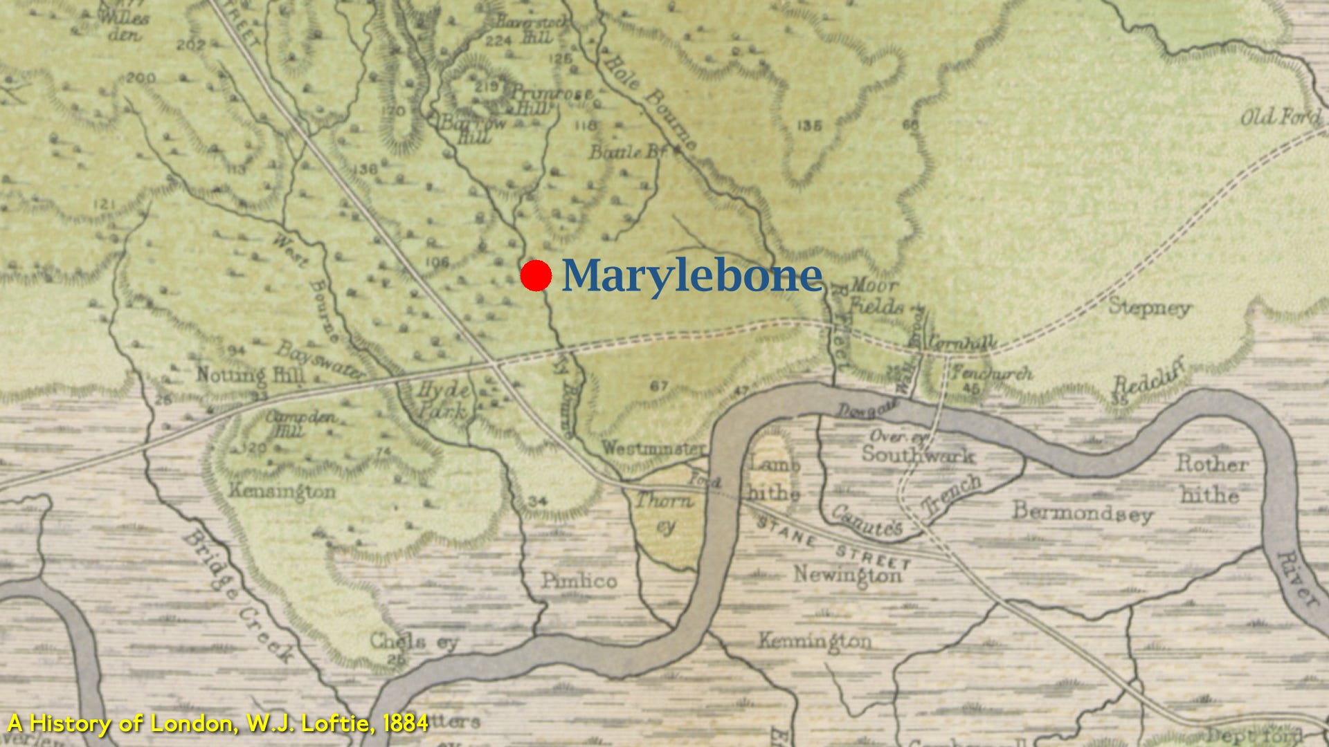
I would claim nowadays that Marylebone is bounded by the Marylebone Road, Portland Place, Oxford Street and the Edgware Road in a parallelogram styley.
I'd further say that Marylebone station is a bit of an outlier and the wrong side of Marylebone Road to be actually located in Marylebone.
And I'd be wrong.
Way back in time, Marylebone village was on the eastern bank of the River Tyburn and in 1400 a parish church dedicated to St Mary was built there.
The settlement was known as ‘Tyburn’ after the local stream. Not far away, at what is now called Marble Arch, an infamous set of gallows was erected in 1571 with the 'Tyburn’ name. Public relations was a thing even in the 16th century and the locals tired of saying “No! Not the bleedin’ gallows. We’re a village on another site and we had the name first”
The villagers took inspiration from their new church and began calling the hamlet St Mary-bourne - the bourn bit of the name coming from the stream.
The stream flowed beside what became Marylebone Lane, which still preserves its curve within today's grid pattern of streets.
Over the next few years, the spelling of the village settled down and became Marylebone without the ‘Saint’ prefix. As the settlement had a church and was the largest place hereabouts, a parish was formed and kept the name St Marylebone. A Metropolitan Borough of London covered the area between 1900 and 1965 and was called the ‘Borough of St Marylebone’.
Here’s a modern view of the immediate area:

On exactly the same footprint, here is John Roque’s map from the 1750s:
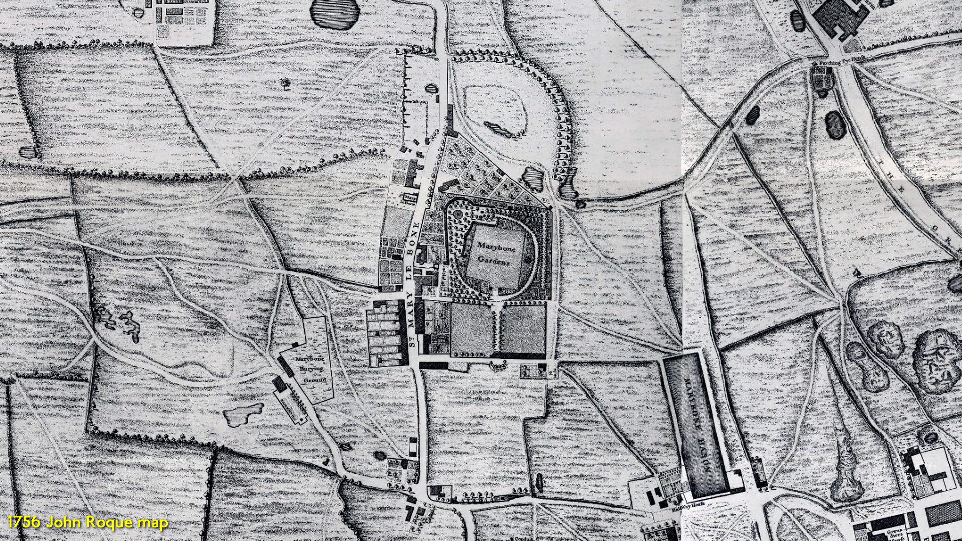
Marylebone is still in the countryside during the 1750s though that decade would bring a big change in the shape of the New Road cutting across the scene and altering the future.
But since this was countryside very near the metropolis, Marylebone Gardens appears on the Rocque map. This was a popular 18th-century pleasure garden and operated from around 1650 to 1778 - one of several fashionable entertainment venues that flourished in London during this period.
The gardens featured tree-lined walks, bowling greens and outdoor dining areas where visitors could enjoy refreshments. They were particularly famous for their musical entertainment, hosting concerts and performances that attracted fashionable society. The venue was known for its more intimate atmosphere compared to the larger Vauxhall Gardens south of the Thames.
The gardens were especially popular during the summer months.
The site was located roughly in the area bounded by what is now Marylebone High Street and Wigmore Street. The gardens eventually closed in 1778 as the area became increasingly developed for residential housing, and the fashion for such pleasure gardens began to decline.
St Marylebone became an important parish and its boundaries stretched far to the north.
Marylebone Park Farm was owned by the royal family and I've marked its 1799 boundary in red here.
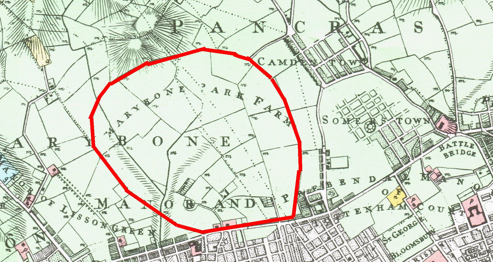
This farm became John Nash's Regents Park and the modern map clearly shows that Regent's Park has exactly the same shape and boundary, stretching to the same extent as the original farm.
But this was all called Marylebone.
In 1710, John Holles, Duke of Newcastle, had purchased the manor for £17,500.
His daughter and heir, Lady Henrietta Cavendish Holles, by her marriage to Edward Harley, Earl of Oxford, passed it into the family of the Earl of Oxford, one of whose titles was Lord Harley of Wigmore. She and the earl, realising the opportunity for fashionable housing north of Oxford Street, commissioned the surveyor and builder John Prince to draw a master plan that set Cavendish Square plumb centre in a rational grid system of streets.
The New Road - London's first bypass - was laid out in 1756. This eventually was renamed Marylebone Road in this area. One of the ideas of the New Road would be that it would act as a brake to development. London could stretch to the southern boundary of the New Road and beyond it would remain countryside. This suited the planning of the aristocratic developers of Marylebone.
The Harley heiress Lady Margaret Cavendish Harley married William, 2nd Duke of Portland, and took Marylebone into the hands of the Bentinck family.
Beautiful Georgian terraces and garden squares started appearing: Portman Square, Manchester Square, Cavendish Square.
These were carefully planned communities designed to attract London's growing merchant class and nobility. Many roads were named after the landowners - names of their aristocratic titles and also their original family names.
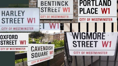
The modern extent of Marylebone begins to appear: Marylebone Road, Edgware Road, Oxford Street and Portland Place.
Here is a map from about 1800 showing the development of the area.
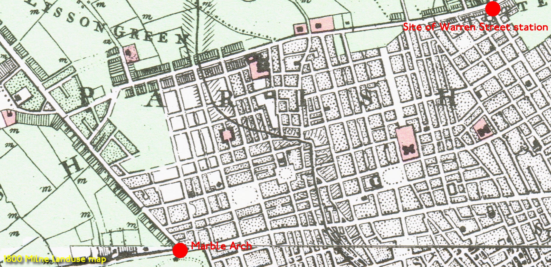
Edgware Road and the New Road - Marylebone Road - define the limit of urban expansion. The cartographer - Milne - shows the River Tyburn crossing his map and through the centre of Marylebone.
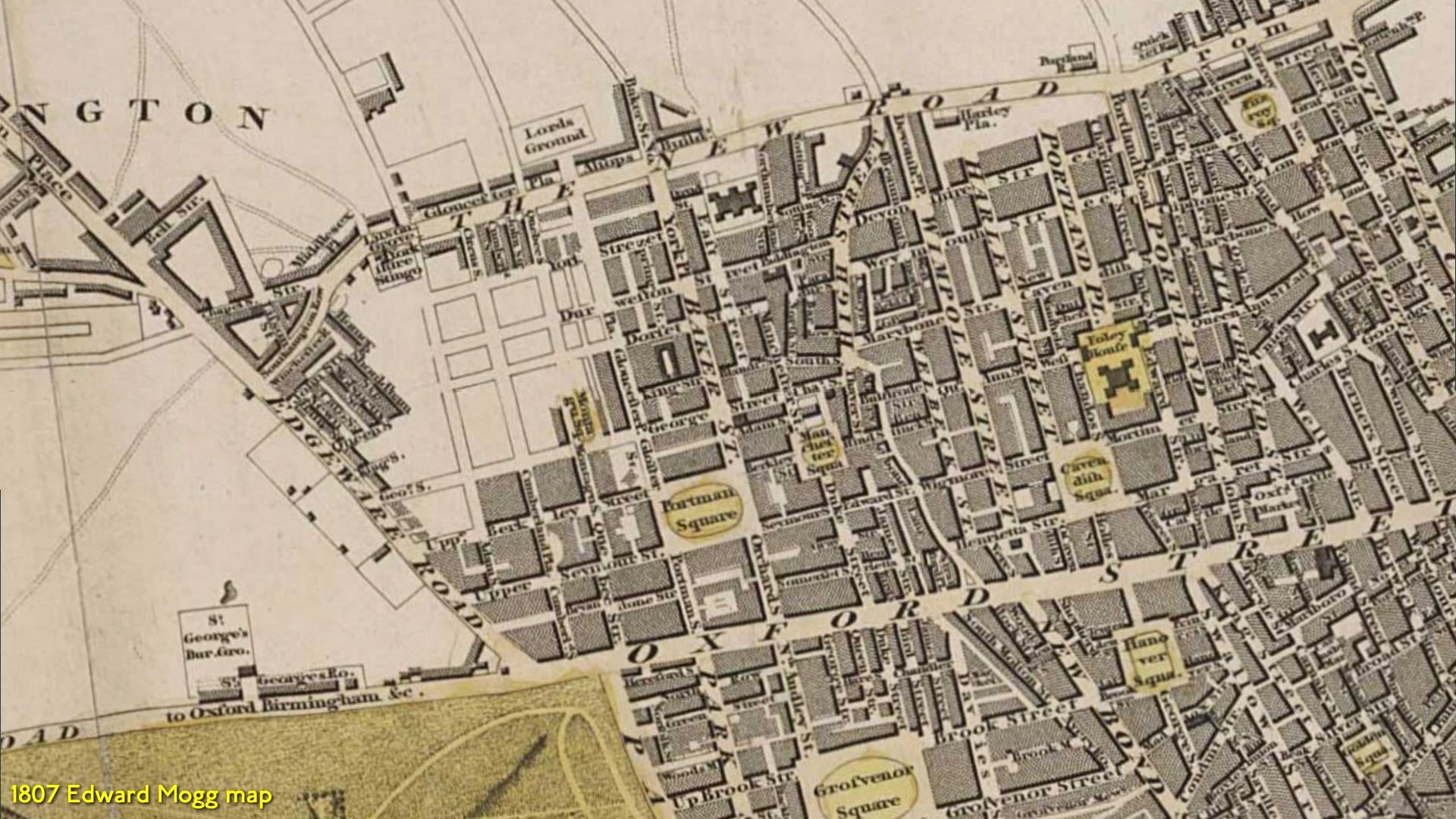
The embryonic Marylebone as a suburb is better shown on this 1807 map.
The first incarnation of Lord's Cricket Ground is on the map. It later moved to St John's Wood but this is why is was called the Marylebone Cricket Club - the MCC.
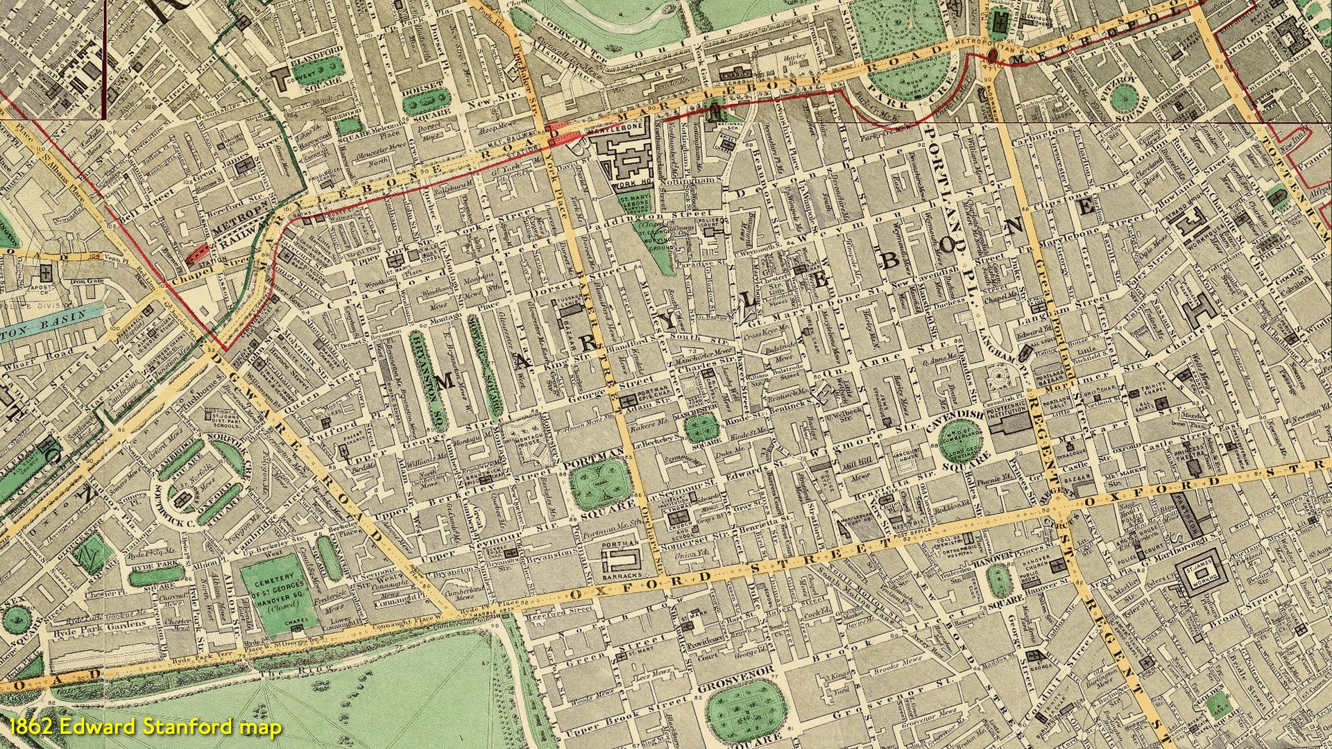
By the mid Victorian era, Marylebone had stayed seriously fashionable. This is when Harley Street emerged as the focus of London's medical profession - a reputation it still holds today.
Development leapfrogged the Marylebone Road and this area to its north got called Lisson Grove. Lisson Grove sounds like a modern street name but it was an older hamlet which went through a number of name changes.
There’s a lot of Marylebone history missed here - I can’t write forever! Doctors, Beatles, buses and more. 2
But when the Great Central Railway built its terminus in the Lisson Grove area at the turn of the twentieth century, the railway company decided to call this station Great Central. Many people opined: "That's a ridiculous name!". Neither ‘great’ (the second smallest London railway terminus) nor ‘central’.
So they chose Lisson Grove as the name for a few moments but decided this was the wrong image too. And it got called Marylebone.
By now it wasn't actually in what Londoners called Marylebone. Such are the shifting sands of London suburb names.
NOTES
Marrowbone Jelly
As part of this tome, I was going to write about the Yorkshire Stingo pub on Marylebone Road - a famed venue also with rear gardens. Known for Yorkshire folk, balloons and omnibus services. The Londonist beat me to it, so that incarnation of this article can wait for another day.
Bored with summer reading? I say all of the above in a video:
Great read. Thanks for the history. We are going to spend two nights there on our return to the UK in early September. All the best.
Rosie
Here's the FamilySearch 1851 parish maps I mentioned on YouTube. You need an account, but it's well worth it:
https://www.familysearch.org/en/mapp/