


Make West-Way Safe!
A 1930s anti-road protest which foresaw things to come

Much has been written about the 1960s London Ringway scheme. This ‘much’ includes myself in an earlier post. The London Ringway scheme was a proposed huge car-friendly motorway scheme which would have destroyed much of London in its path.
There were four planned circular motorways around London.
Ringway 1 would be the ‘London Motorway box’, comprising the North, East, South and West Cross Routes.
Ringway 2 was an upgrade of the North Circular Road and a new motorway to replace the South Circular Road.
Ringway 3 was a new road, the northern section of which became part of the M25 from South Mimms to Swanley via the Dartford Crossing. It was intended for traffic bypassing London and was a central government scheme outside the remit of London County Council.
Ringway 4 was more commonly known as the "North Orbital Road" and "South Orbital Road". The southern section became part of the M25 and M26 from Wrotham Heath to Hunton Bridge. Sections of the A405 and A414 through Hertfordshire follow its proposed route. The road was planned to connect a number of towns around the capital including Tilbury, Epping, Hoddesdon, Hatfield, St Albans, Watford, Denham, Leatherhead and Sevenoaks.
Due to the huge construction costs and widespread public opposition, most of the London Ringway scheme was cancelled in 1973 but the Westway, some of the West Cross Route and a part of the East Cross Route were significant parts which were actually built. Outside of London, the M25 was finished - bits of Ringways 3 and 4 - and look how congested that became.
Ringway 1 was planned to form a roughly rectangular box of motorways around inner London. Much of this scheme would have been constructed as elevated roads on concrete pylons, with routes designed to follow existing railway alignments to minimise land acquisition.
One major section of elevated motorway in this scheme was actually built and opened in 1970 and connected Marylebone Road with the West Cross Route at Shepherd’s Bush. A tiny section of the West Cross Route was completed (and at the time designated the M41), taking drivers south to the Holland Park roundabout.
After linking motorists to the West Cross Route, the new 1970 motorway continued west down to street level to connect with an existing stretch of road called Westway. This already ran from Wood Lane at White City stadium to Western Circus (later called Savoy Circus). It was a 1930s short piece of highway connecting onwards to the 1920s Western Avenue. It relieved congestion for those inter-war motorists attempting to navigate their way to Savoy Circus and the A40 through the back streets of East Acton.
The new later section of motorway hadn’t a name and so the ‘Westway’ name was extended all the way to the Marylebone Flyover.
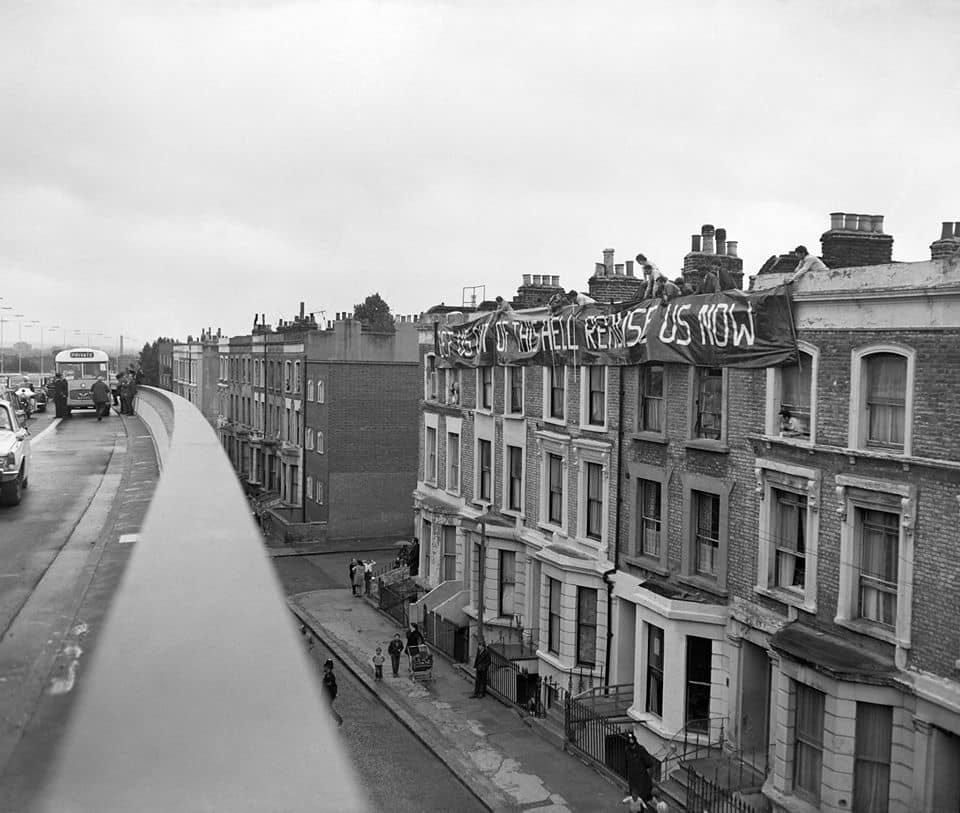
Socially, things did not go well. Once the motorway opened in 1970, housing along the elevated section was truly blighted. Some residents displayed huge banners reading 'Get us out of this Hell – Rehouse Us Now' from their windows and protesters disrupted the opening day by driving a lorry the wrong way along the new road.
The practical reality of elevated inner-London motorways kick-started the opposition which led to the cancellation of the entire project just three years later.
But opposition to new London road schemes had a longer pedigree.
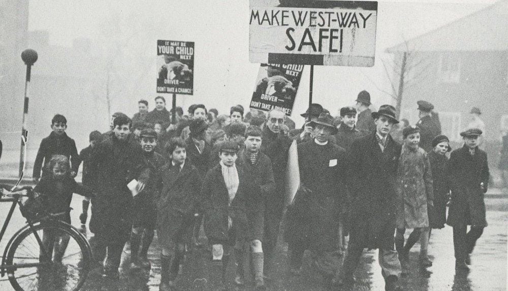
In January 1937, a march took place over the safety crossings on that first section of road called Westway, protesting against the high speeds on the road and lobbying for a 30mph speed limit.
When the Western Avenue was first constructed in the 1920s, all intersections with other roads were flat junctions with roundabouts, resulting in significant congestion at busy periods.
But the ‘Westway’ section was clear, allowing London-bound drivers to pick up a bit of speed and hence the 1937 road safety protests.
Before the invention of pelican crossings - traffic light-controlled affairs which cause traffic to stop and obey a red signal, Westway only had standard crossings marked by ‘Belisha beacons’. These had been only recently introduced as a concept under Section 18 of the Road Traffic Act, 1934. A Belisha beacon is an upright crossing marking, still required by the later (1950s) zebra crossings in the UK and named after the Minister of Transport in 1930s, Leslie Hore-Belisha. He gets namechecked in the video below.
Children were running across the crossings in the gaps between vehicles which weren’t notably slowing down. It was not a good thing.
The demonstrations were jointly organised by the parents of the new White City estate and the local churches. Speeds on Westway made crossing the road to local shops and schools unsafe and so 250 people crossed and re-crossed the inadequate crossings that day, holding up the traffic. Banners bore slogans: 'Make West-way Safe' and 'It May Be Your Child Next Time'.
The protests did have a result. A series of ‘subways’ - in the underpass sense - were constructed. The war intervened soon after and the coming of the zebra crossing and more importantly the pelican crossing made matters better nationwide.
The protests were notable enough for the newsreel cameras of British Pathé to be sent along to record them. While I’ve been busy describing this protest in text, the plummy voice on the original film does a much better job so I’ll leave you in the late 1930s with him.
NOTES
A pub called “The Western” was built beside Western Circus and named after it. In time a cinema called the Savoy was built on the junction and the name slowly changed to Savoy Circus, now its official name. Both the cinema and pub are gone now.
A link here to the full Pathé movie - full in the loosest sense as even the extended version lasts only two minutes: www.britishpathe.com/asset/43368/
On a really nerdy note, I love the W in the Make West-Way Safe banner. It’s a pre-war stylised W and also used on London Underground roundels at West Brompton and Edgware stations. I also love the fact that West-way had a hyphen.
Thank you, Scott. Proof - were any more needed - that there is nothing new under the sun (or the pouring rain, where I am).