


The car-friendly London that might have been
The story of the London Motorway Box and the ring roads beyond

London found itself at a crossroads in the 1960s - figuratively and in some cases, literally. The streets, designed for the era of the horse and carriage, were now choked with the fumes and noise of countless cars and lorries. As the population continued to grow alongside burgeoning post-war wealth, the number of vehicles on the road skyrocketed, London found itself in the grip of a crisis.
The situation was dire, with traffic congestion bringing the city to a standstill on a daily basis. Commuters spent hours trapped in their cars, inching forward at a snail's pace as they tried to navigate the labyrinthine streets. Businesses suffered as deliveries were delayed and employees arrived at work frazzled and exhausted. The very lifeblood of the city was being strangled by the unrelenting gridlock.
There had been a cultural shift after the war. The population had become more aspirational, with inside toilets, televisions and washing machines slowly becoming considered essential to modern living. And a pre-war reliance on a huge UK rail and bus network to get around, had started to look old-fashioned. A modern family needed its own vehicle. The road was to be king and Dr Beeching’s cuts to British Rail seemed a logical step towards our gleaming, collective, car-driven future.
In response to the mounting congestion on old infrastructure, the Greater London Council hatched an ambitious plan. They envisioned a network of high-speed motorways that would encircle the city, providing a bypass for through traffic and alleviating the pressure on the inner city streets. These motorways, to be known as the London Ringways, were to be the saviour of the metropolis - the solution to the seemingly intractable problem of traffic chaos.
The Ringways were to consist of four concentric rings, each one further out from the city centre than the last.

The innermost ring, Ringway 1, was to be an elevated motorway that would run through the inner city, soaring above the rooftops on massive concrete pillars. This "motorway in the sky" would provide a quick and easy route for traffic passing through London, while also serving as a distributor for traffic heading to and from the centre.
Ringway 2 was to be the next ring out, running roughly along the route of the present-day North and South Circular Roads. This motorway would provide a vital link between the outer suburbs and the inner city, allowing commuters to bypass the congested streets of the inner boroughs. Ringways 3 and 4 were to be the outermost rings, providing a bypass for long-distance traffic and connecting the city to the wider motorway network.
The scale of the project was staggering. The Ringways were to be a feat of engineering unparalleled in London. Miles of elevated motorway would be constructed, cutting a swath through the dense urban fabric. Whole neighbourhoods would be razed to make way for the new roads, with thousands of homes and businesses demolished in the process. The Ringways were to be the largest infrastructure project in the city's history - proposed to be a testament to the ingenuity and ambition of the planners and engineers who conceived them.
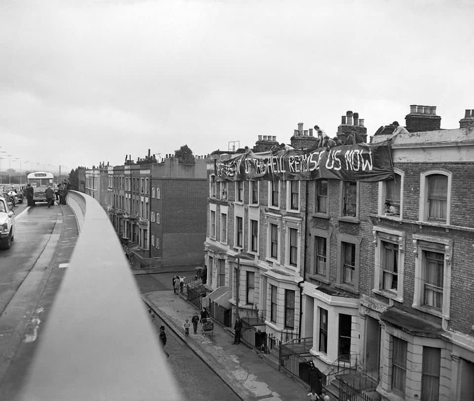
The Ringways were not without their critics. Many saw the project as a monstrosity, a blight on the city's landscape that would destroy communities and sever long-standing social and economic ties. The elevated sections of the motorway, in particular, were seen as a visual intrusion that would loom over the city like a malevolent presence, casting shadows over the streets below. Environmentalists warned of the impact the motorways would have on air quality and green spaces, while social activists decried the displacement of working-class communities to make way for the new roads.
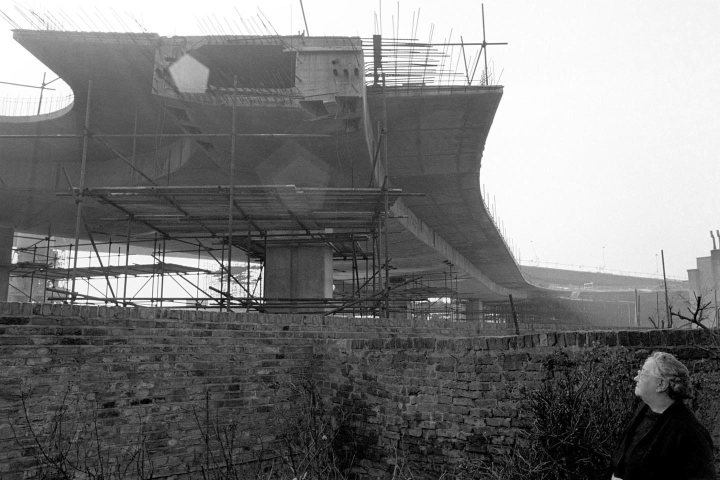
Despite these objections, work on the Ringways began in earnest in the late 1960s. Construction crews descended on sections of east and west London, tearing up streets and demolishing buildings with ruthless efficiency. The first sections of the motorway began to take shape, with towering concrete pillars rising from the ground like the bones of some gargantuan beast. The city was transformed into a vast construction site, with the constant din of jackhammers and the roar of heavy machinery filling the air.
As the first sections of the Ringways began to take shape, opposition to the project began to mount.

Two major sections of Ringway 1 were completed.
The Westway from Marylebone Road to East Acton with a spur - called the M41 - from it to the Holland Park Roundabout at Shepherd’s Bush was finished as the 1970s dawned. The M41 was to be extended south from Shepherd’s Bush as the West Cross Route, laying waste to Chelsea and Battersea.
Meanwhile, the East Cross Route, running alongside the River Lea, then under the Blackwall Tunnel to emerge at the A2 in the Blackheath area was also completed.
The North Cross Route was planned to cut an ugly swathe from Harlesden to Hackney through Belsize Park and other posher areas. The South Cross Route would link Battersea and Blackheath via Camberwell.
Residents of the affected neighbourhoods banded together to fight the motorways, staging protests and lobbying elected officials - both MPs and councillors - to halt construction. They argued that the Ringways would destroy the very fabric of their communities, tearing apart social networks and erasing cherished landmarks. The elevated sections of the motorway, they claimed, would create a physical and psychological barrier between neighbourhoods, isolating communities and exacerbating social inequality.
As the opposition grew, the political winds began to shift. The GLC, once a staunch supporter of the Ringways, began to waver in its commitment to the project. The cost of the motorways, originally estimated at around £1.7 billion (equivalent to approximately £28 billion in 2024 money), had ballooned to unprecedented levels, and there were growing concerns about the environmental and social impacts of the project.
In 1973, the GLC, now under the control of a newly elected Labour administration, made the momentous decision to cancel the Ringways project. The move was met with a mixture of relief and anger, with some hailing it as a victory for people power and others decrying it as a short-sighted capitulation to the forces of NIMBYism. The cancellation of the Ringways marked a turning point in the history of London's transport infrastructure, a moment when the city began to rethink its relationship with the automobile and embrace a more sustainable, people-centred approach to urban planning.
In the years that followed, London began to invest heavily in public transport, expanding the Underground network and introducing new bus routes to serve the city's growing population.

The idea of the Ringways, however, never entirely went away. In the 1980s, the government revived plans for an orbital motorway around the city, this time further out from the centre. The result was the M25, a 117-mile (188-kilometre) motorway that encircles Greater London, providing a (now congested) link between the city and the surrounding region. This closely followed route ideas for Ringway 3.
Today, the legacy of the Ringways lives on in the city's transport infrastructure. The elevated section of the Westway, originally intended to form part of Ringway 1, still stands as a reminder of the grand ambitions of the 1960s planners. The North and South Circular Roads, earmarked for upgrades as part of Ringway 2, remain vital arteries for the city's traffic. (The South Circular Road less so, to be fair). And the M25 owes its existence to the same desire to provide a bypass for through traffic and alleviate congestion in central London.
The story of the London Ringways is a tale of grand ambitions and bitter disappointments, of visionary plans and grassroots opposition. It is a story that highlights the challenges of balancing the needs of a growing city with the desire to preserve its character and protect its communities. The Ringways may never have been built, but their legacy lives on in the ongoing debate over how best to keep London moving while preserving its unique identity.
Yet the fundamental challenge that the Ringways sought to address - the need to keep a growing city moving while preserving its quality of life - remains as pressing as ever. As London continues to grow and evolve, it will need to find new and innovative ways to meet the transport needs of its citizens while protecting the environment and promoting social equity. The story of the Ringways serves as a reminder of the scale of this challenge, and of the need for bold and visionary thinking in the face of complex and intractable problems.
In the end, the London Ringways remain one of the great "what ifs" of London's transport history. Had they been built, they would have transformed the city in ways that we can only imagine, for some better but mostly for worse.
Very enjoyable! Worth noting, though, that Westway was never part of Ringway 1 - the Ringways would have been bigger and wider. If you wish to understand the scale of their ambition, the GLC considered Westway to be a Secondary Road.
Really great article. Ten years ago or so at college we used the sports centre underneath the Westway at Ladbroke Grove. Someone pointed out the unfinished junctions on the intersection (visible from Google Earth too) which would have completely decimated Oxford Gardens, Balliol Road etc. Thank God the planners didn’t get to finish what they started