


All roads lead to Chipping Barnet
Not all roads - but two very important ones

In this blog, I have a habit of galivanting all over London and coming to rest near a tube station. Then - on a normal day - I’d write about that area.
This time, I’m doing no such thing. We’ll start in what at the publish date of the map above (1922) was still called Chipping Barnet by nearly all. It was a Hertfordshire town, famous for its horse fair and for a 1471 battle. By the 1920s, urban London was creeping up Barnet Hill, joining it to London’s absorbed set of towns and villages. It was still surrounded by countryside on three sides. To be fair, it still almost is, thanks to the Green Belt.
We’re not even starting in the centre of Chipping Barnet, but a couple of hundred yards further on.
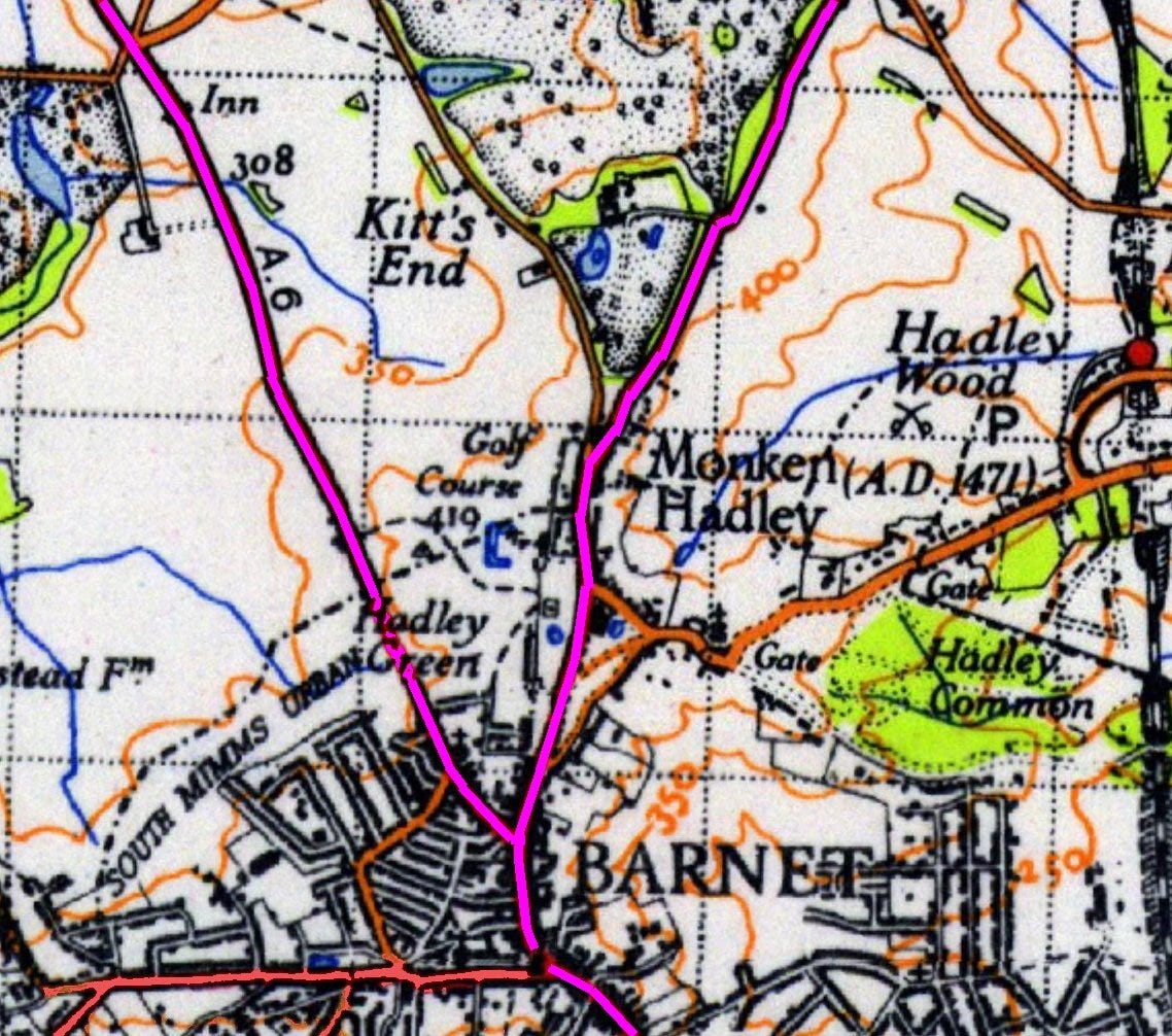
A road junction north of Barnet Church held a unique distinction. It was the start of a primary A road - i.e. the roads numbered A1 through A9.
That particular single digit A road started neither in London (as did the A1 through A5) nor Edinburgh (the A7 through A9). The A6 started in Chipping Barnet and from there, went all the way to Carlisle.
The 1920s road numbering scheme
The A Roads of Great Britain were designed after the First World War to sort out a good deal of chaos. With growing car ownership and the beginnings of guides as to where these new drivers might head on a day out, it was becoming not enough to proclaim: “Head for the South Downs”.
How? Drive south and hope for the best?
Thus some clever people designed a numbering scheme. Many roads of Great Britain would be assigned a number after a starting letter of A, B or C. These was largely the work of the Ministry of Transport which inherited the ideas of the pre-war ‘Road Board’ - established in 1909 to administer Vehicle Excise Duty (money raised by taxation to pay for new road construction)
The A roads were to be the main roads which connected major centres of the country. The B roads led off the A roads to connect them to villages. The C roads were smaller and narrower still and most of these C numbers did not survive into modern times.
At the heart of the new system were the two national capitals of London and Edinburgh. From those two, the single-digit A roads headed for the coast as follows:
A1 London to Edinburgh
A2 London to Dover
A3 London to Portsmouth
A4 London to Avonmouth
A5 London to Holyhead
A6 London to Carlisle
A7 Edinburgh to Carlisle
A8 Edinburgh to Greenock
A9 Edinburgh to Wick (well, actually Scrabster near John O’Groats)
These single digit roads were numbered in a clockwise direction. This enabled the gloriously logical system of ‘sectors’ which allowed a scheme to number all other A, B (and C) roads.
Since these roads headed for the coast and were arranged clockwise, these sectors could be:
Sector 1: between the A1 and A2
Sector 2: between the A2 and A3
Sector 3: between the A3 and the A4
And so on…
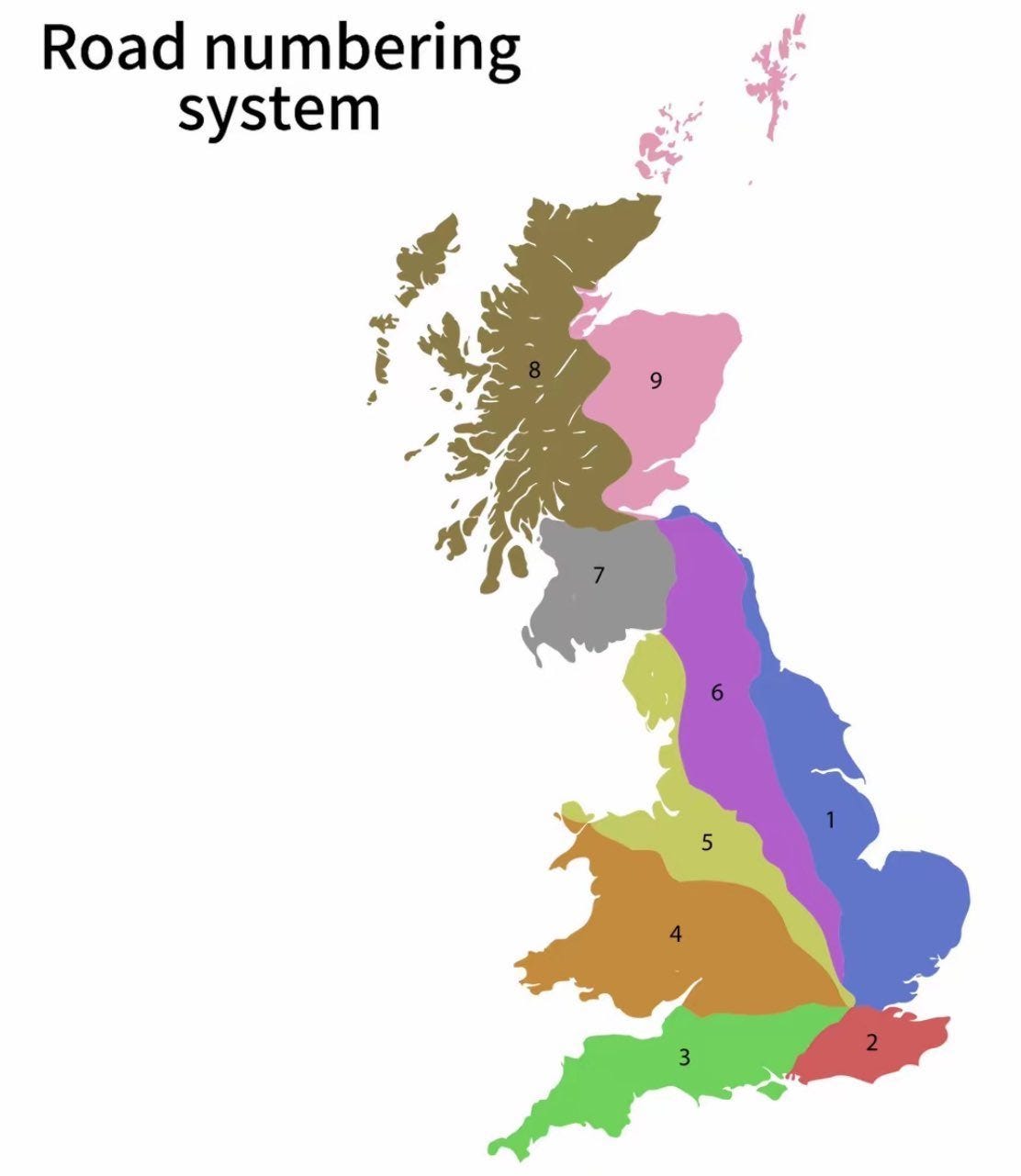
Roads within a particular sector would begin with the sector number.
Surrey A and B roads are numbered with 2 or 3 depending upon which side of the A3 the road is. Roads in Scotland begin with a 6, 7, 8 or 9 apart from a tiny selection of roads between the A1 and the sea which begin with a 1. All roads in the south west begin with a 3.
If a road crossed sectors like the A38, beginning at Land’s End but ending in the English Midlands, it took the number of the lowest sector it crossed.
There was a bit of logic to the two digit A roads: the A10, A11, A12 and A13 are numbered clockwise. The A20 through A25 similarly.
Now, if you’ve read this far for the trivia, you’re in luck.
Some subtleties of the scheme
Sector 1 is defined by the A1. Hence the A127 near Southend and the A199 near Edinburgh - 400 miles away - all follow numbering logic, being the clockwise side from the A1. But roads in north Kent which should have been in sector 1, aren’t. The Ministry of Transport decided that the Thames should form the boundary rather than the A2. The A2 is a very lonely major A road, not as important as its siblings.
Beside the Balmoral Hotel in Edinburgh - where JK Rowling finished the Harry Potter series in a hotel room, the A1, A7, A8 and A9 all used to meet at a single junction. The A8-A9 was a single combined road at the beginning of the numbering scheme only separating into independent roads eight miles west of Auld Reekie. The A1, A7 and A8 still meet at the junction.
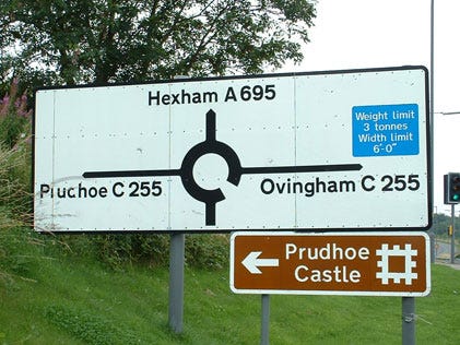
Carlisle is not quite on the coast but it too has a single junction where the A6 and A7 need to meet to make the scheme work.
The London A roads all started in different but nearby places within the City of London, apart from the A5 (Marble Arch) and A6 (Chipping Barnet, not then in London). Thus in the City of London the road numbering system is a mess since the sector boundaries are a mess here.
The A5 and A6 started in different places, but met at a junction in St Albans, before again going their independent ways.
The scheme begins to break down
There’s a coda to the breathtaking logic of the original scheme. Not so sad, as the logic mostly holds, but silly stuff started to happen.
When the motorways were built, they began to follow the A road logic but this all broke down when the M5 was numbered. It starts in sector 3 and ends in sector 4. Motorways thus now have their own numbering system which I won’t go into here.
Because the Ministry decided in the 1970s that drivers were stupidly following primary A roads and not the brand new motorway alternatives, the A5 now disappears as a number in Edgware near to the M1 junction and reappears at the M1 junction in Dunstable. The A5183 now follows the old A5 through Elstree, St Albans and Redbourne.
The A9 in Scotland befell a similar fate and now begins somewhere near Falkirk due the arrival of the M9.
Chipping Barnet
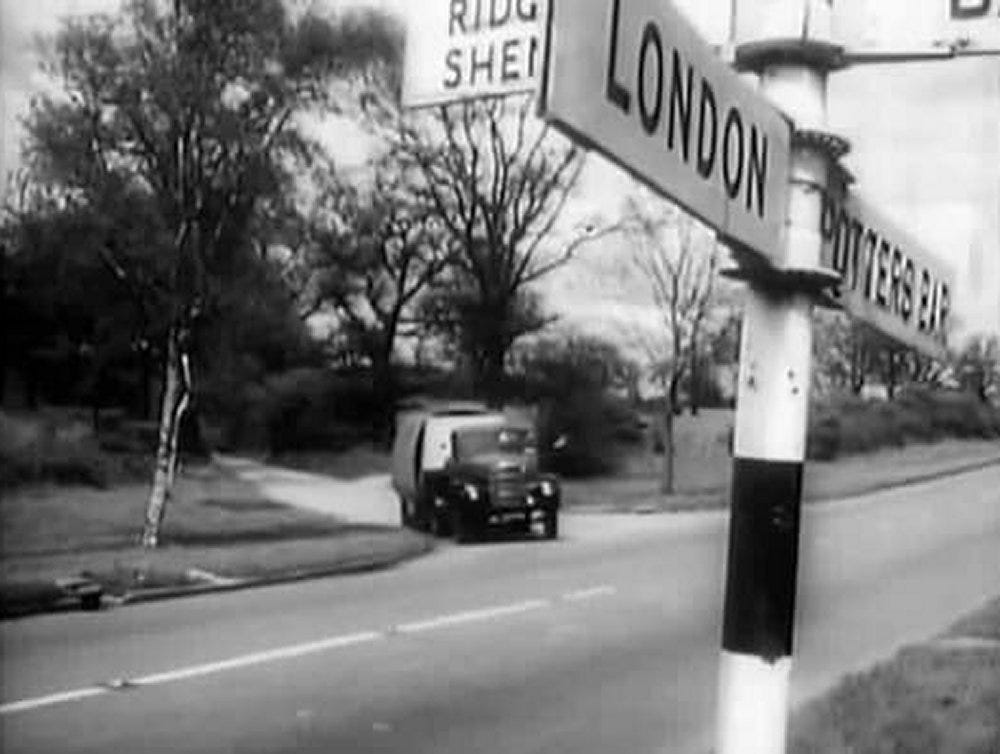
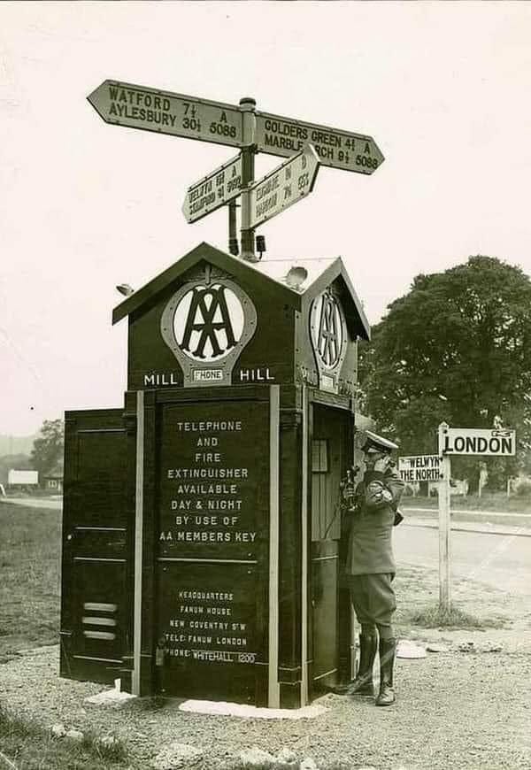
Barnet Hill was a struggle for horse and then drivers - by the 1920s it was steep and congested but still carrying the A1 north and having the A6 start just north of Barnet church.
Like the Finchley Road a century before (built as a bypass to the steep Hampstead hill), the Barnet By Pass was built as part of the huge road building schemes of the mid 1920s. It avoided steep hills and took a new route through Hampstead Garden Suburb, Mill Hill, past Borehamwood to Bignall’s Corner.
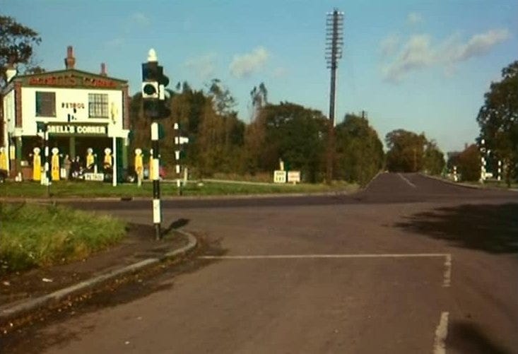
Above Bignall’s Corner - now the site of South Mimms services - before the M25/A1(M) junction obliterated the scene. We are viewing from the southern terminus of the old A6. The A1 runs left to right. Over the junction is the road to Barnet - the former A6.
Since the Barnet By Pass left the A1 at Highgate and ‘remet’ the old A1 at Bignall’s Corner, the Ministry of Transport made a decision during the 1930s. It would renumber the By Pass as the ‘A1’ and call the old A1, the ‘A1000’.
Since the A6 road in this scheme would now cross the new A1 on its way to Chipping Barnet, it was decided to start the A6 instead at Bignall’s Corner.
This held sway from the 1930s until the 1980s. The A6 now started in South Mimms.
Then the M25 became a thing. Its northern route was to follow the A6 between St Albans and South Mimms. The UK didn’t need two parallel primary roads and so the motorway took over the route of the A6 here.
With the A5 now beginning in the Luton area, the A6 would also now be numbered only from Luton northward.
And so endeth the tale of Chipping Barnet’s place in road numbering history.
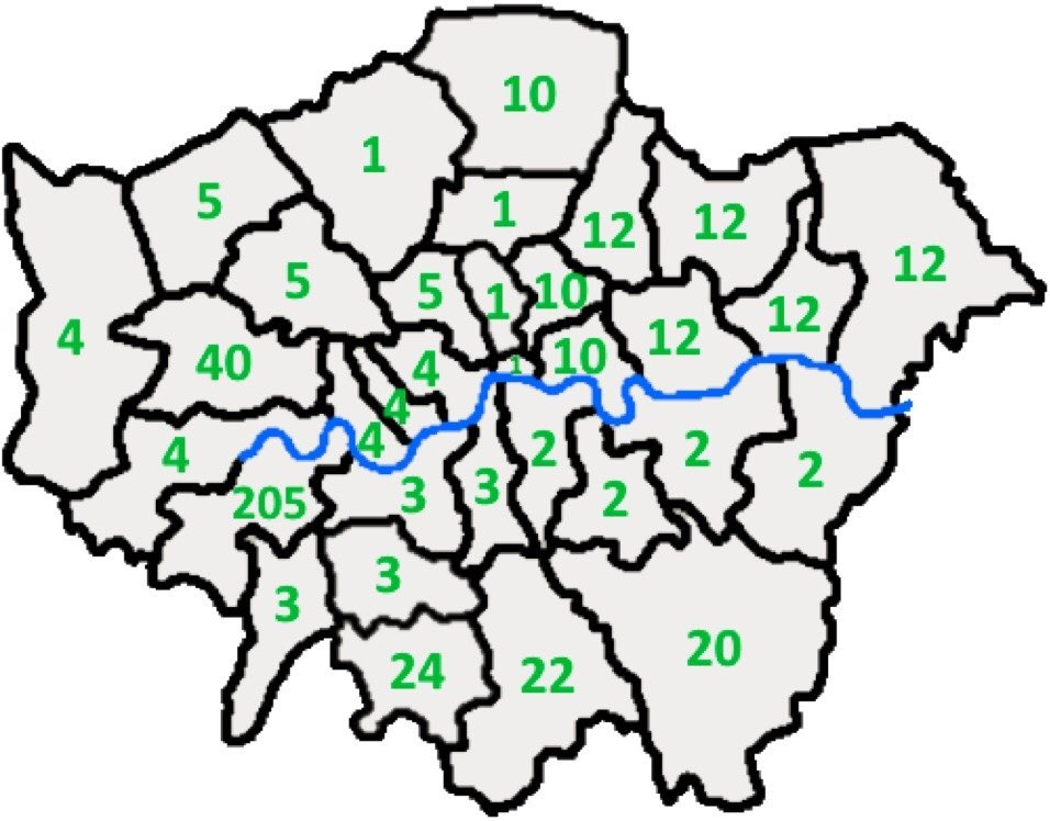
Below Niche maps of London number 622: The lowest numbered A roads passing through each borough. No idea why we need such a map though but “Go, London Borough of Richmond Upon Thames!”
Good stuff. I read an account about the A road logic about once a year and then subsequently forget how it worked. Framing it in terms of my local area (Barnet, Borehamwood, Elstree) has helped me remember, I think.