


The River Westbourne
The story of a London river lost to time

We are going to take a historical walk along a lost London river. We’ll find some surprises along the way.
The hills of Hampstead Heath provide the source of three lost rivers of London - the Fleet, the Tyburn and Westbourne. These rivers were long buried underground and the modern streetscape contains few hints at these former watercourses.
That last one - the River Westbourne - flowed through Kilburn, Maida Vale, Westbourne Green, Bayswater, Knightsbridge and eventually joined the Thames in Chelsea. All of those placenames - even Chelsea - refer directly to the proximity of this river.
Eagle-eyed readers will note that I’m calling this river the Westbourne from the “off”. This wasn’t its name until the nineteenth century. We’ll deal with the other names as we go along here but I’ll keep calling the main river in general by its modern moniker.
Until the nineteenth century, the entire route of the Westbourne was open to the fresh air. Slowly the river was culverted and buried - parts of the river north of Hyde Park survived until 1871, and the outfall can be observed at low tide on the Thames, but otherwise the river is now invisible.
It is usual with a river - even a buried one - to have tributaries and the Westbourne was no different. There were many small streams - originating from Brondesbury, Kensal Green and North Kensington - that joined our river along its course .
But I will concentrate to begin with on the two headwater streams - the Cannon Stream and the Kilbourne.
I realise that the exact route of the watercourse is quite niche information. Perhaps you’ll know the area well and think: “Um.. Well I never knew there was a river under there”. Or maybe you’re ambitious enough to wish to walk the route - if so, well done!
Either case, detailed routing information is written in an indented style and you are thus permitted to skim over it if you’re not so interested in such a walk. Once the two headwater streams join up, we’ll all go on the walk - whether on foot or in an armchair.
The Cannon Stream
The Cannon Stream became the name for the west branch of the minor brooks which, once merged together at Kilburn and became the Westbourne.
The northernmost source of the Westbourne is, noted by some sources, in the area of Whitestone Pond in Hampstead. This lies next to the highest point in the whole of north London which gives the Westbourne some bragging rights. This highest point these days is occupied by a mobile phone tower. The pond was named after the white milestone marking the entrance to Hampstead, and its waters were once used to give military horses somewhere to drink.
From the pond the stream is imperceptible apart from times of heavy rainfall but it sometimes runs towards the southwest from Whitestone Pond. It takes a line parallel to, but to the north, of Judges Walk.
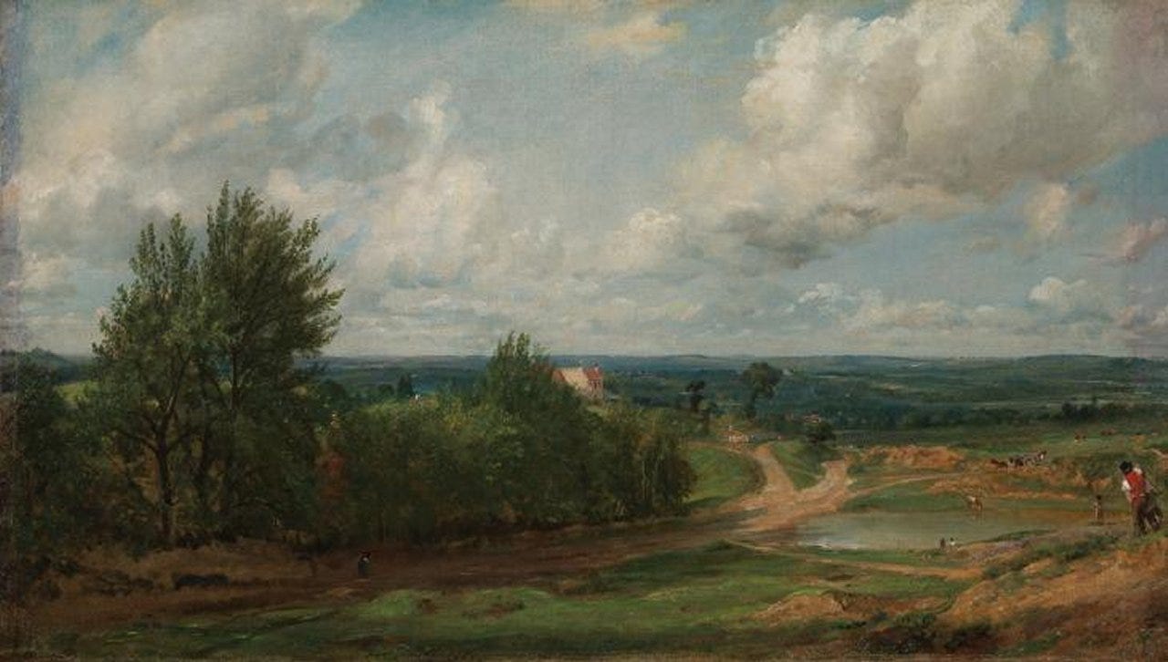
Branch Hill Pond has now disappeared, but the Westbourne once flowed through it. The location of the pond can still be seen as a distinct hollow in the heath which is still grassland at this point. John Constable sat on a stool and created an oil painting of Branch Hill Pond.
The rivulet continues to flow southwest, under modern Spedan Close, which when built in the 1970s was the most expensive council housing in the country. It then follows the line of modern Reddington Gardens. Here it combines with two tributaries; one from Oak Hill and another from Telegraph Hill. It follows the line of Heath Drive before crossing under the Finchley Road where a very small dip in the road can still be ascertained.
Across the Finchley Road, Cannon Stream follows Cannon Hill downhill. Charles Cannon was a dye merchant who lived at Kidderpore Hall, West Hampstead and converted an old footpath into Cannon Hill - it was this hill which lent its name to the stream. The stream reached the rear of an old inn called the ‘Cock and Hoop’ and fed a small pond on West End Green.
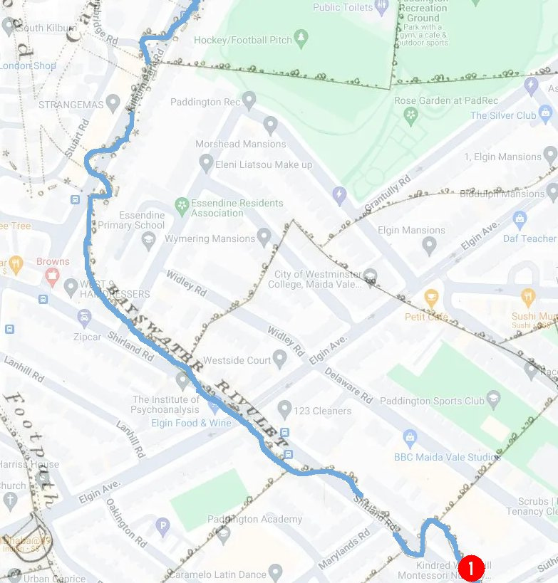
Crossing West End Lane, Cannon Stream now flowed south through the fields which separated the boundary between two estates. It passed to the west of elevated ground in West Hampstead, under the modern Solent Road, crossing present-day Sumatra Road, crossing underneath two railways and then following the course of the length of Kingsgate Road until reaching Kilburn, where Cannon Stream joins the other main source to form the main river Westbourne.
Just to be overly complete here, other roads that the Cannon Stream crossed on its route are Holmdale Road, Narcissus Road (which English Indie rock band The Hours, named an album after), Liddle Road, Quex Road, Iverson Road, Maygrove Road and Birchington Road.
The Kilbourne
The second main feeder stream for the Westbourne was the Kilbourne, rising in a pond within the grounds of a grand house called Frognal Hall in Hampstead. Both the old mansion and the pond have now disappeared but the pond lies underneath what is now 62 Frognal.
This branch was originally called the Kilbourne - cye-burna (royal stream) or cyna-burna (cow’s stream) . Sometimes it was spelled Kelebourne and gave its name to modern Kilburn. Kilburn is the first downstream London placename with a watery connection derived from the river.
Flowing south from the pond through a field, it crossed the line of the modern Hampstead Tunnel and then following the route of Frognal. It crosses under the Finchley Road where Frognal meets the main road.
It flows under the modern O2 Centre and behind Finchley Road tube station before following a course west of the modern line of Goldhurst Terrace. At the time of an 1829 map of the area, there was a pond to the west - near to the junction of Fairhazel Gardens and Greencroft Gardens. On the way to this point, the Kilbourne crosses Broadhurst Gardens and Canfield Gardens. It also runs underneath the hidden glory that is Compayne Open Space.
Then under the railway to the west of South Hampstead station and after crossing underneath Belsize Road, the stream roughly follows modern Ainsworth Way, following under the modern parkland estate to that road's north. Under Abbey Road it flowed and then Mortimer Crescent and Mortimer Place, two roads with literary connections.

The combined river
Congratulations if you’ve followed this by actually walking the walk. You no longer have to complete two different walks since the Kilbourne and Cannon Stream join together at Kilburn Priory (which dated from 1134 - the days of Henry I).
And from now on, we’ll all together proceed on the virtual - or real - walk down the river.
The priory was situated where the river crossed at the present site of the junction of Kilburn High Road and Belsize Road. The priory had been constructed on the location of the cell of a hermit known as Godwyn and was home to the community of Augustinian canonesses.
The priory, was dedicated to the “Blessed Virgin Mary and St. John the Baptist”, became a renowned resting place for pilgrims stopping by on their way to St Albans. The river supplied the Priory’s moat and provided the inhabitants with water and fish until the dissolution of the monasteries in 1536 when the building was destroyed.
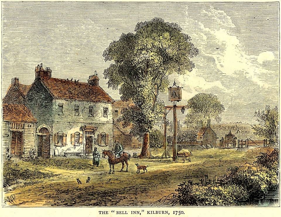
Priory lands incorporated a mansion and a guesthouse or ‘hostium’ which may have constituted the basis of the Red Lion pub (believed to have been founded in 1444) and the Bell Inn on Watling Street which found itself in due course next to a fashionable spring, opening in about 1600.
The water from this spring was discovered to contain properties similar to Epsom Salts and gave rise to spas and pleasure gardens, including the Kilburn Wells.
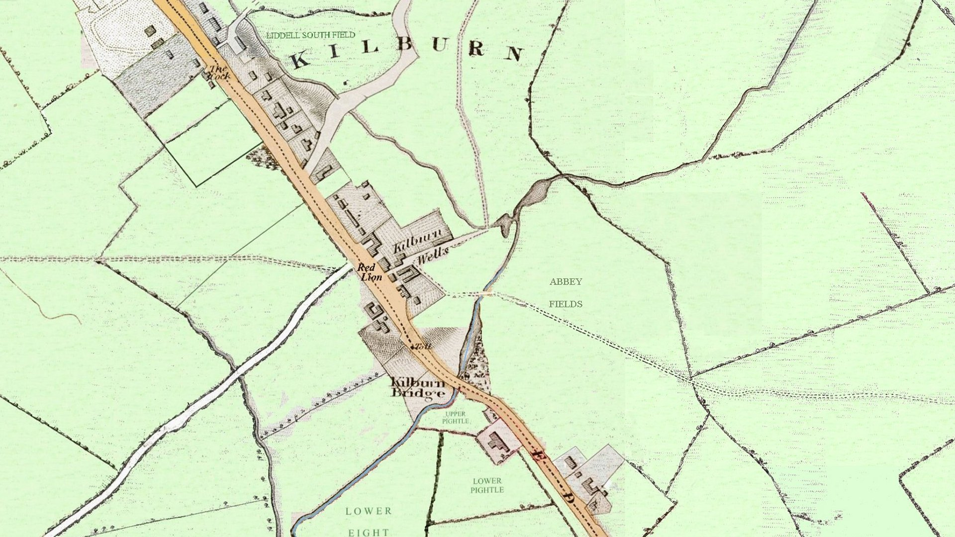
Kilburn Bridge
Back to nomenclature. The section of the river between here and Hyde Park started off being called the Kilbourne, then mysteriously gained the name of the Bayswater Rivulet (more of that later). As the river started to get buried underground, it was more and more referred to as the Ranelagh Sewer. We’ll continue to call it the Westbourne.
The two branches of the upper river having combined, they ran under Kilburn Bridge on the Edgware Road/Kilburn High Road and emerged on the other side.
If you happen to be on a bus going along Kilburn High Road, the river is still there but buried. But you can feel a slight dip in the road where Kilburn Bridge used to be. It was located outside the Marriot Hotel beside the road called Kilburn Priory.
This bridge was thought to have been built in the mid 13th century by the Prior of Kilburn. In 1826 the original stone bridge with a Gothic arch survived, flanked by brick portions added at two different periods. In more modern times, there is no trace of the structure. There was a farm called Kilburn Bridge Farm next to it until 1839 and its farmlands included the future Kilburn Park Road and Carlton Vale.
Kilburn Park Road
The river next precisely follows the course of Kilburn Park Road which was built in its valley - the river was culverted and the new road built over the top, beginning in 1855. As the river was further culverted, Kilburn Park Road was extended south along the Willesden boundary - marked by the river. This administrative boundary still runs between the London boroughs of Brent and Westminster but the reason for the line of the boundary - right along the middle of Kilburn Park Road - is maybe lost to residents and their annoying different waste bin collection regimes, either side of the road.
By 1861, the culverting had reached the future Carlton Vale. In 1850 the Reverend Edward Stuart sold 47 acres to a consortium of five developers, of whom the largest was James Bailey. They laid out roads and sewers and divided the site among themselves, subletting to smaller firms who built a few houses each. Carlton Vale was originally called Carlton Road. Several of the contractors aimed high with their early efforts but the isolated, muddy location - the vale being the flood plain of the Westbourne - failed to attract buyers and the estate remained incomplete for several decades. A new type of building, in red or multi-coloured brick, was used from the 1860s onwards. Carlton Vale was extensively rebuilt after Second World War bombing.
Kilburn Park Road’s extension south met the site future Chippenham Road in 1861. Often straightened and culverted as the Ranelagh sewer, before being built over, some of the Westbourne's course was still open (with its course straightened) in 1871.
Shirland Road
Now entering the W9 postcode, Shirland Road follows the course of the Westbourne as the river turns sharply to the southeast.
I’ll illustrate the course of the river south with a series of older maps. The 1860s map - Map B - shows the route of the river and the modern 2020s Google map overlay shows that the river first follows Kilburn Park Road, turns to the southeast and starts to follow Shirland Road.
There were houses at the south end and on the west side of Shirland Road, by 1870.
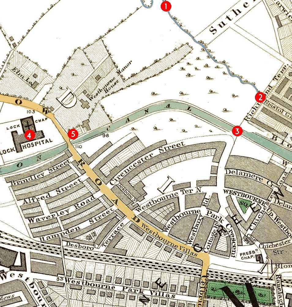
The point marked 1 on Map C immediately above corresponds to the point marked 1 upon the previous map, Map B
Between points 1 and 2, the river continues to flow underneath Shirland Road, crossing Sutherland Avenue.
The river then reached Bristol Gardens. As late as the 1860s, one end of Bristol Gardens (2) still commanded uninterrupted country views to the north and west.
The Kilburn Aqueduct
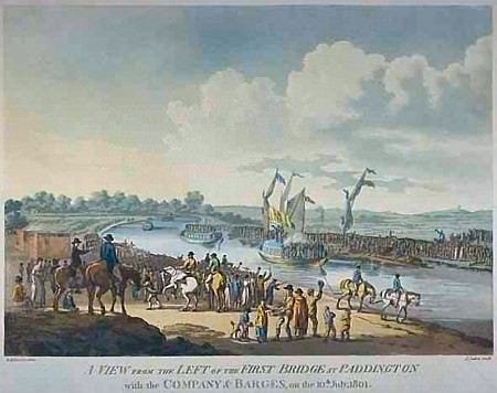
The Grand Union Canal had been dug in the first decade of the nineteenth century and the Westbourne had to be diverted under the new canal.
Point 3 marks one of the curiosities of the Westbourne - the Kilburn Aqueduct. This was situated at the point where today’s Clifton Villas meets Blomfield Road.
When the Grand Union Canal was built, the valley of the River Westbourne ran through what were known as the Kilburn Fields. To span the valley, the new canal was placed on a 30-foot-high embankment to cross the river.
Development of the area after the canal was built was causing the Westbourne to become an open sewer. Around the early 1820s locals complained of the awful smell emanating from the Westbourne. It was culverted for a considerable distance either side of the aqueduct by 1823.
Let’s mix in another map…
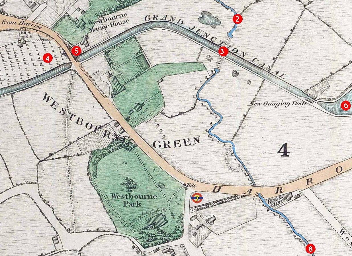
This map - Map D - is dated some thirty years prior to Map C. During the 1830s, we reach the village of Westbourne Green. Let’s linger here for a while to get our bearings.
Westbourne Green
Westbourne Green was a major settlement with a manor house, other very large houses and a toll booth on the Harrow Road. It was situated just east of the spot where the Harrow Road (still) has a bridge over the Grand Union Canal.
It was called Westbourne Green as it was west of the bourne (river). There is still a Westbourne Green but the name now refers to a park, having fallen out of favour as a placename.
Point 3 marks the spot of the Kilburn Aqueduct where the river dives under the Grand Union. In the 1830s, the south side remained rural.
Point 4 on Map C above marked the site of the London Lock Hospital - the first voluntary hospital for venereal disease. The Lock Hospital moved to Harrow Road beside the canal in Westbourne Green in 1842. After it closed in 1952, the hospital was demolished and the site is now occupied by flats. On the earlier 1830s-era Map D, the site is still rural. Today, Admiral Walk would enter the grounds.
Point 5 marks the entrance to Westbourne Manor House. The monks of Westminster were granted this farm at Paddington in the year 959. The estate known in the 19th century as the manor of Westbourne, formed part of the abbey's lands in the parish.
A series of owners then followed. Extensive improvements reported in 1815 included the planting of ground between the house and Harrow Road and probably a tree-lined walk which ran from the rear alongside "William's field" to the Westbourne. The house survived until 1866 but had been replaced by the western end of Sutherland Avenue in 1867.
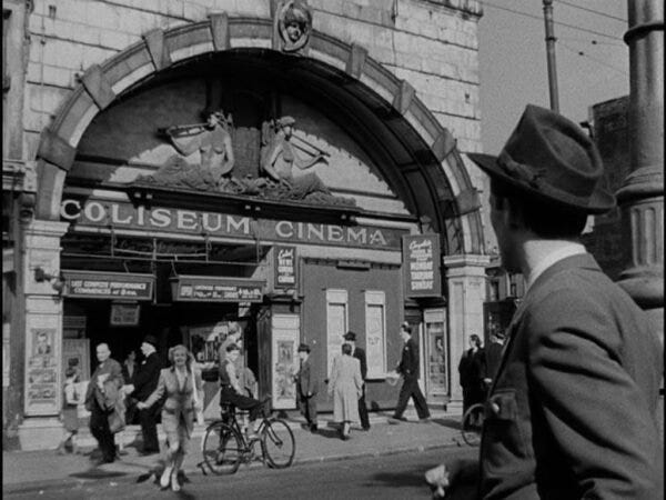
By the 1950s, point 5 marks the exact location of the former Coliseum Cinema as featured in the movie ‘The Blue Lamp’. It’s also now flats.
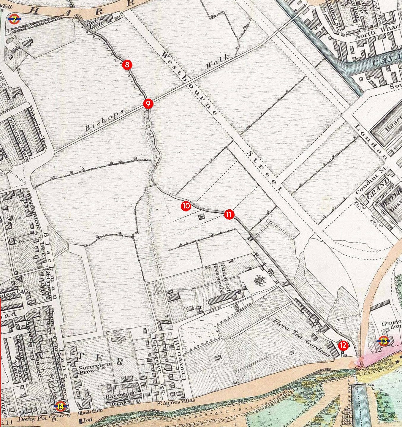
Point 6 is simply a reference to help get our bearings - the Little Venice basin and similarly point 7 (on top of the roundel symbol) is the location of Royal Oak station, built beside the Westbourne Green toll booth on the Harrow Road.
Not marked with a red blob, Harrow Road crossed the Westbourne at a place then called Red Lion Bridge. The Red Lion pub, a country pub beside the bridge, was moved 100 yards to the east when the first major change to the area came - the building of the Great Western Railway.
The next map - Map E - is still an 1830s map. The area is mostly agricultural but some new roads such as Westbourne Street (now Westbourne Terrace) are being laid out.
Bayswater
Point 8 - the reference between Maps D and E marks the modern junction of Orsett Terrace and Gloucester Terrace.
The river flowed south now towards Bishop's Bridge Road. This area mostly consisted of streets with the prefix ‘Westbourne’ and was sometimes known as Westbournia. The proliferation of Westbourne names may have caused the river to become known by the name. Why this happened is a mystery.
At point 9, the river crosses under a footpath called Bishop’s Walk (eventually Bishop’s Bridge Road and the point is now at the junction of Gloucester Terrace). Bishop’s Walk provided a short cut to Paddington Green. The cutting of the GWR line across the middle of Westbourne Green was begun in 1836, necessitating a slight northward realignment of Harrow Road. Since the railway obstructed the Paddington Green end of Bishop’s Walk, the footpath was replaced by Bishop’s Bridge Road, soon extended westward as Westbourne Grove. Most of the area between Bishop’s Road and the railway had been filled by 1855.
After crossing Cleveland Gardens, the Westbourne reaches Cleveland Square at point 10. During the Second World War, Cleveland Square sustained two direct hits. There was an anti-aircraft barrage balloon stationed in the gardens of Cleveland Square and until recently one of the flower beds still had the huge concrete block with steel attachments buried among the plants. This bed has been named the ‘Balloon Bed’ in tribute and there is a commemorative plaque positioned there.
As the former river flows towards Hyde Park, two street names reflect their heritage: Upbrook Mews - which the river flows directly underneath (point 11) and Brook Mews North. (There was also originally a Brook Mews South).
At the ‘Flora Tea Gardens’ - point 12 - we’ve reached the Bayswater Road. Across the river at this point would now be Lancaster Gate station (point 13) but then the location of the riverside ‘Crown Inn’. Point 14 marks the modern Queensway station.
I won’t spend too much time on the subject of Bayswater. It warrants its own post.
But the name Bayswater is derived from the 1380 placename Bayards Watering Place - a ‘bayard’ being a horse which would have taken water from the river. This name was applied to the bridge that the road here crossed at the site of the Flora Tea Rooms. For reasons unknown, the river became called the Bayswater Rivulet north of here. Like the Westbourne name, it’s a back formation - the river giving its name to the settlement which in turn gave its name back to the river. It’s all very strange.
Hyde Park
Once in Hyde Park, our river was locally called the Serpentine River due to the shape of its course, even before it was dammed.
As it crossed royal Hyde Park, the Westbourne originally formed eleven natural ponds. In 1730, Queen Caroline, wife of George II, asked for an ornamental lake to be created. This became The Serpentine at the eastern end and the Long Water at the western. Originally the lake was fed by the River Westbourne entering at the Italian Garden at the north-western end of the Long Water. During the 1730s, the lake filled to its current size and shape. The redevelopment was carried out by the Royal Gardener - Charles Bridgeman - responsible for damming the Westbourne, and who also dug a large pond in the centre of Kensington Gardens (The Round Pond) to be a focal point for pathways in the park. At the time of construction, artificial lakes were typically long and straight. The Serpentine was one of the earliest artificial lakes designed to appear ‘natural’, and was widely imitated in parks and gardens nationwide.
The Westbourne ceased to provide the water for the Serpentine in 1834, as the river had become polluted. The lake’s water was thereafter pumped from the Thames.
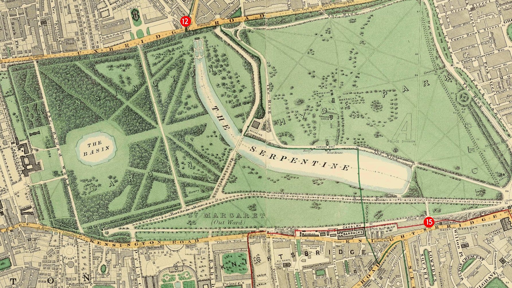
For illustrative purposes, we come to Map F dating from the 1860s simply to show the entrance of the Westbourne into Hyde Park at point 12 and the exit at point 15.
Knightsbridge
The river exited south from Hyde Park under Knight's Bridge (now Knightsbridge). The bridge was known for highwaymen and a duel between knights. It is recorded that the citizens of London met Matilda of England at the Knight's Bridge in 1141. Knightsbridge is now home to expensive shops, but it was previously the scene of many riots. In 1556, at the time of Wyatt’s insurrection, the rebel and his followers arrived at the Knight's Bridge hamlet at nightfall, and stayed there all night before advancing on London.
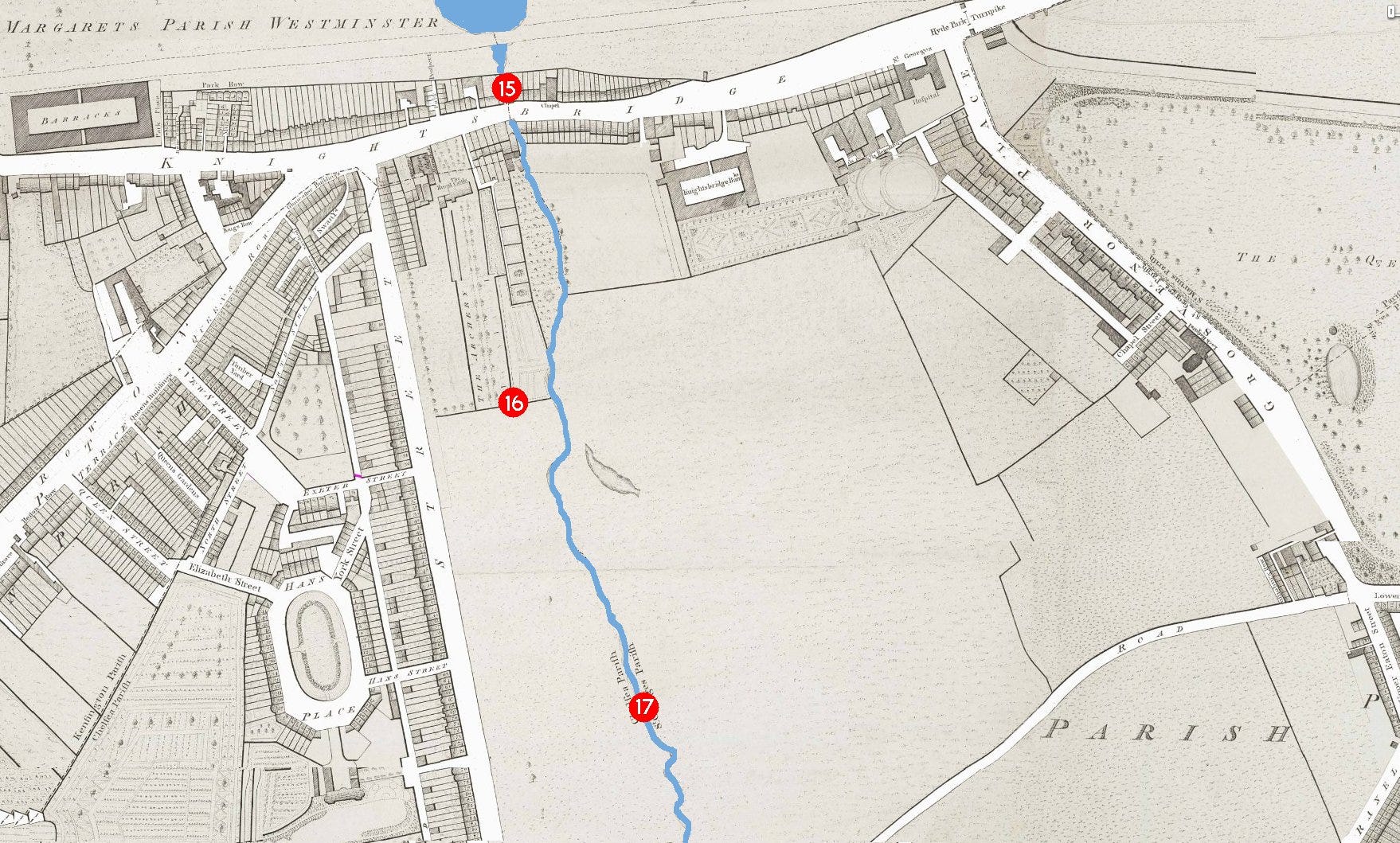
We will now revert to a map from 1799 for the rest of the journey to the Thames, showing a then-still rural area. All the way to the Thames, the Westbourne river marked the parish boundary between Chelsea and Westminster. It still marks the London borough boundary (City of Westminster with the Royal Borough of Kensington and Chelsea) and, like in Kilburn, today’s locals may wonder why the boundary is exactly where it is.
Belgravia
In 1824, Richard Grosvenor, 2nd Marquess of Westminster had commissioned the development of many buildings centred around Belgrave Square and Pimlico. The man he commissioned to develop this area was Thomas Cubitt, a builder from Norfolk and a partner, Seth Smith. The area became known as Belgravia.
The course of the Westbourne reaches Lowndes Square at point 16 (Map G). This residential garden square is home to some of the most expensive properties in the world. Roman Abramovich bought two stucco houses in the square in 2008 worth £150 million (then a jaw-dropping sum). Lowndes Square was developed on the west bank of the Westbourne in 1836 as part of the Cadogan Estate, also by Thomas Cubitt and Seth Smith. It was once part of the estate of William Lowndes of Chesham, after whom it is named.
Pont Street (once Bridge Street) which crosses the Westbourne at point 17 (east of Cadogan Lane) has long been a fashionable street. Pont Street is referred to in Evelyn Waugh’s novel ‘Brideshead Revisited’ (1945), as a place related to typical English snobbery.
Map H continues the 1799 map south.
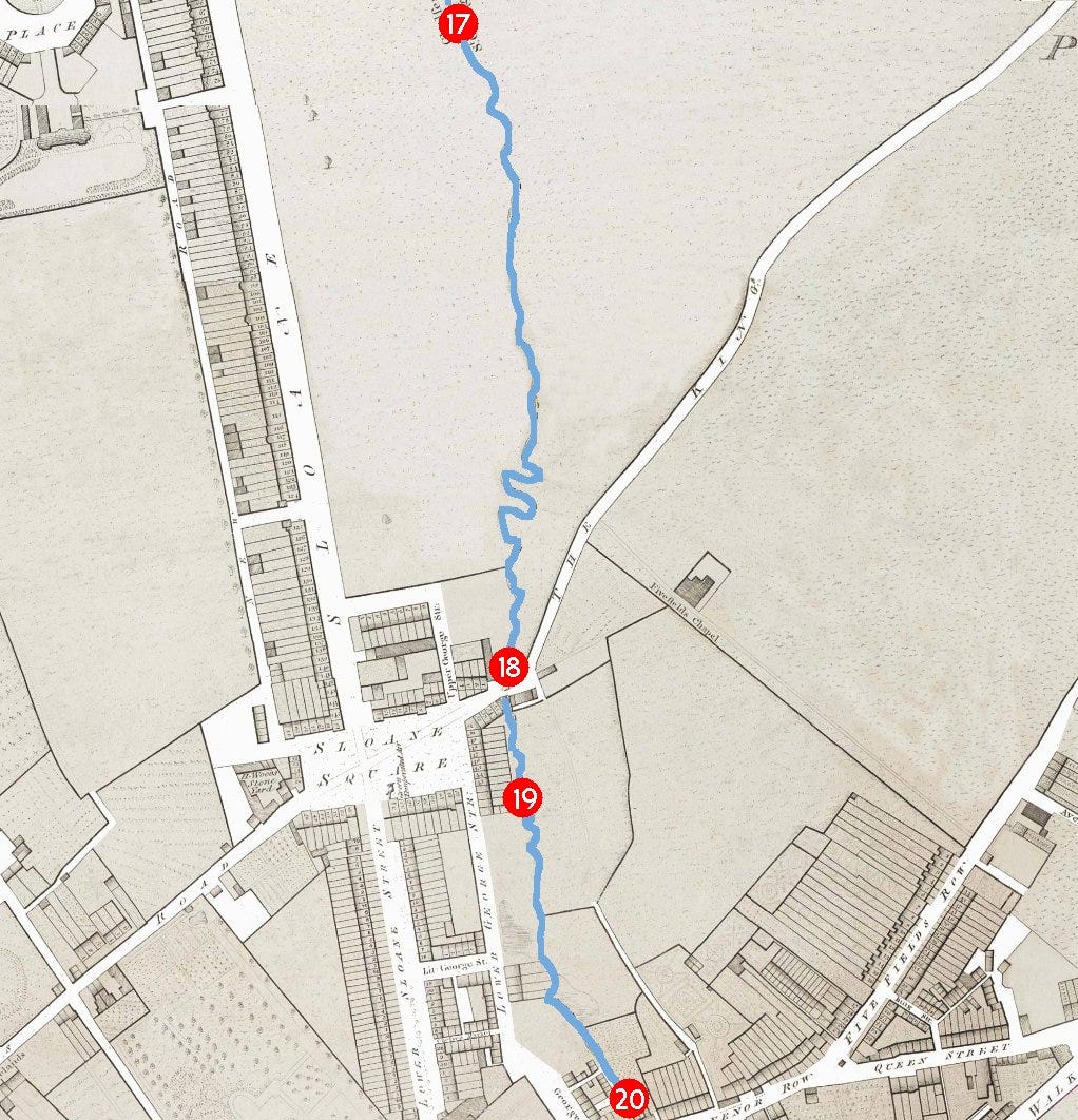
The bridge over the Westbourne at Sloane Square (point 18) was called Blandel Bridge - later renamed Grosvenor Bridge. It was about twelve feet wide, and had walls on either side of a plank high enough to protect passers-by from falling into the river. It was nicknamed “Bloody Bridge” going back as 1590 - so-named (allegedly) following the murder of Lord Harrington’s cook who was attacked and beaten to death by highwaymen. A more substantial bridge, 16 feet wide and lined by high walls, was built in the reign of Charles II.
Sloane Square originally looked much the same as it does today, except that the square was an open green space enclosed by wooden posts, connected by iron chains. It was here that Queen Charlotte’s Royal Volunteers often assembled, and marched off in military order to Hyde Park, headed by their band. In the early 1980s, it lent its name to the Sloane Rangers, the young underemployed and ostentatiously well-off members of the upper classes. Lady Diana Spencer, before she became Princess of Wales, was considered the epitome of a Sloane Ranger.
Sloane Square station was opened on 24 December 1868 by the Metropolitan District Railway when the company opened the first section of its line. The construction of the station was complicated by the crossing of the site by the River Westbourne. The river had to be carried above the platform in a large iron pipe (19) suspended from girders. It remains in place today.
In 1886, a collaborative effort between Lord Cadogan and the Chelsea vestry led to a comprehensive reorganisation of the roads south of Sloane Square. Lower Sloane Street underwent expansion, while several locations to the east of Lower Sloane Street, including Little George Street, Chelsea Market, Evans Cottages, Viner Place, George Place and Woods Buildings, were subject to closure. The closure of Lower George Street resulted in the creation of the broader Sloane Gardens, seamlessly connecting with Lower Sloane Street. The erstwhile meandering course of The Ditch, following the line of the Westbourne, was replaced by Holbein Place. This transformation also introduced Holbein Mews (point 20), linking Holbein Place to Lower Sloane Street.
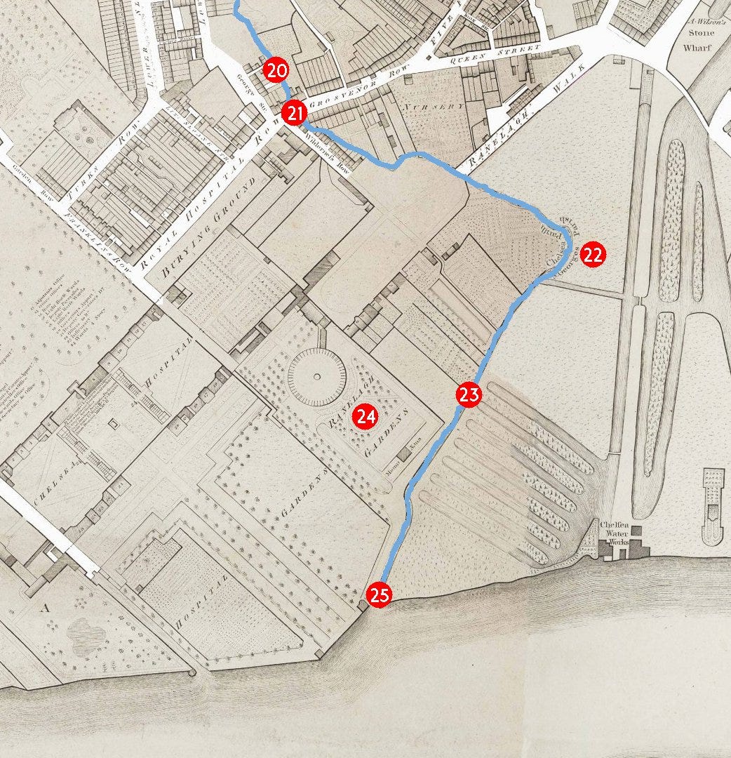
Chelsea
The thoroughfare from Westminster to Chelsea village was originally spanned by a stone bridge (21), noted in records from 1587. In the early 19th century, this stone bridge was succeeded by a single-arch brick bridge located in Grosvenor Row, later known as Pimlico Road. A notable inn in Grosvenor Row, recognised as "The Three Compasses" or the "Goat and Compasses," served as a prominent starting point for Pimlico omnibuses. The colloquial name "Goat and Compasses" may be a phonetic alteration of the phrase "God encompasseth us." The renowned Chelsea Bun House in Grosvenor Row not only introduced the famous Chelsea Bun but also housed a museum of curiosities. The Bun House was managed by various members of the Hand family.
As we progress into Chelsea and pass Ranelagh Grove, the river approaches Ebury Bridge Road. Ebury Bridge itself crossed the Grosvenor Canal, not the Westbourne. During the mid-19th century, Ebury Bridge Road briefly bore the name Commercial Road and ran alongside the Chelsea Barracks. The road, in its original layout, ran adjacent to the Westbourne as it navigated a bend toward the River Thames (at point 22 beside today’s Laverose Way).
In 1857-8, Chelsea Bridge Road was laid out in a straight path from an expanded White Lion Street to the new Chelsea Bridge. 23 marks the point where it crosses the Westbourne, now just to the west of the Ebury Bridge Road junction.
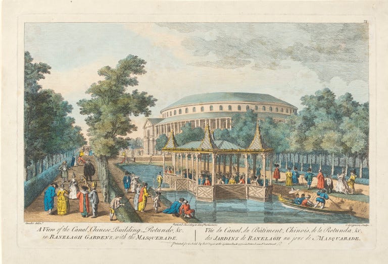
Next to this road, the Ranelagh pleasure gardens (24), inaugurated in 1742, thrived as one of the most fashionable pleasure resorts in the 18th century, accessible both by river and road. In the 1760s, Sir Thomas Robinson, a proprietor of the pleasure gardens, erected a mansion named Prospect Place, residing there until his death in 1777.
In 1803, the pleasure gardens shut, and the Rotunda and other structures were dismantled. Subsequently, this portion of the estate transformed into gardens under the ownership of the Chelsea Hospital. The line of Chelsea Bridge Road resulted in the removal of Ranelagh House.
Upon traversing the contemporary Royal Hospital Grounds, a vestige of the river, a broad quay, converges into the River Thames approximately 270 metres west of Chelsea Bridge. An overflow sewer outfall remains visible during low tide - much of the Westbourne's course has been repurposed for the Middle Level Sewer and the Northern Low Level Sewer.
Our journey is complete.
Mapping notes
1799 mapping: Richard Horwood’s Plan of London
1830 mapping: 1827-29 Greenwood map
1860 mapping: Stanford and Sons (1862-65)