

The map that saved - and condemned - Victorian London
How Charles Booth’s poverty survey gave reformers the weapon they needed - and how they used it on the wrong people

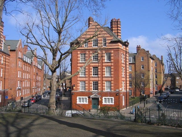
Spring has just about sprung at time of writing and - close your eyes - let’s get ourselves transported to London E2. We’ll drift over the capital of our imagination on a sunny Sunday spring morning and land at Arnold Circus in Shoreditch. (Wear a jacket though as it might be a bit nippy given the earliness of the season)
Perhaps there’s a band playing on the Grade II-listed bandstand in the centre of the circus. We’ll look at the handsome brick tenements radiating outward from where we have landed. They are Arts and Crafts in style, the kind of thing that appears in estate agents’ particulars with words like heritage and characterful. People bring coffee. Dogs are walked. The raised garden, circled by those wide tree-lined avenues, has a slightly theatrical quality - too symmetrical for an accident, too deliberate to be ordinary.
It isn’t an accident. The garden is raised because it is built on a mound. And the mound is built from rubble. The rubble contains some of the pulverised bricks and timbers of the homes of nearly six thousand people who lived here before. People who were evicted without assistance, without alternative housing, without ceremony. Their former abodes were scooped up, piled high and topped with a bandstand.
London does this. It builds its improvements on the bones of what it cleared to make room for them. But the story of Arnold Circus is stranger and darker than most, because the instrument of that clearance was not a railway company; not a slum landlord; not an act of war. It was a map.
The man who counted the poor
Charles Booth was not what you might expect. He was a Liverpool shipowner. He was wealthy, conservative and a successful businessman with no obvious reason to spend seventeen years of his life cataloguing the misery of London’s East End. He began his great survey in 1886, partly out of genuine reforming instinct, partly in exasperation: he believed the socialist agitators of the day were wildly exaggerating the extent of poverty in London. He intended to prove them wrong with data.
He did not prove them wrong.
His team of researchers fanned out across the city, following School Board visitors into homes, accompanying policemen on their rounds, interviewing charity workers and social investigators. They gathered everything: occupation, income, housing conditions, family size, the regularity of work, the character - as they perceived it - of each street. They cross-referenced, debated, revised. And then they translated all of it onto maps.
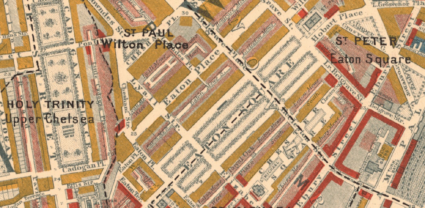
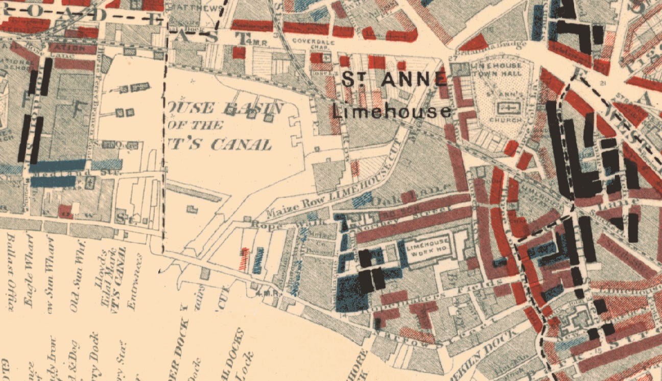
The maps were works of art as much as social science. Each street in London was coloured according to the income and social class of its inhabitants, ranging across seven categories. At the prosperous end: yellow for the wealthy upper-middle class, red for the comfortable middle class. At the other end: pink for the poor but stable, light blue for intermittent poverty, dark blue for chronic poverty. And at the very bottom, for those Booth’s survey designated as the lowest class - vicious, semi-criminal - the colour was black.
When the first maps were published in 1889, covering east London, they caused a sensation. Here was poverty made legible. Here was misery given coordinates. And here, starkly visible against the patchwork of blues and pinks and reds, were the ‘black streets’.
Booth had set out to refute the socialists. Instead, he had produced what remains one of the most devastating indictments of Victorian London ever assembled. His surveys showed that almost a third of Londoners were living in poverty - far more than anyone in power had been prepared to acknowledge. The maps didn’t just record the problem. They announced it, visually, undeniably, to anyone who cared to look.
The vicious, semi-criminal streets
The Old Nichol sat in Shoreditch, bounded by Boundary Street to the west and Mount Street to the east, compressed into a maze of perhaps thirty courts and alleys that had been growing denser and more desperate since the 1680s. On Booth’s map, it was black.
The statistics were, even by Victorian standards, appalling. One child in four died before their first birthday. The death rate from violent crime ran at twice that of the rest of Bethnal Green, and four times that of London as a whole. Official records counted 653 houses across twenty streets, with an average occupation of two and a quarter people per room - but 107 of those rooms held five people or more. There was no running water. Sewage ran through the streets. Many of the properties were makeshift workshops as well as homes, their inhabitants scratching livings making matches, matchboxes, shoes, rope or clothes in conditions that left them exhausted by middle age and dead before old age could find them.
The Illustrated London News had described the Nichol in 1863 as “one painful and monotonous round of vice, filth and poverty, huddled in dark cellars, ruined garrets, bare and blackened rooms, reeking with disease and death.” Nothing had improved in the thirty years since. The streets were so snarled and introspective, so cut off from the wider city by their own geography, that even the police refused to enter alone.
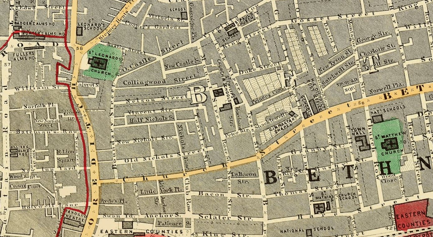
But the Old Nichol had defenders of a particular kind. The Bethnal Green vestry, which held local power over the district, had for years resisted any serious talk of clearance. This was not on humanitarian grounds. Many members of the vestry owned property in the Nichol. They had been drawing rents from those dark rooms, those overcrowded courts, those families dying at twice the London average. And since the vestry also controlled the appointment of members to the Metropolitan Board of Works - the body theoretically responsible for improvement - the same men (always men by the way) who profited from the slum had a hand in blocking its reform.
Booth’s map changed the political weather. You cannot argue, when the evidence is printed in colour on a map anyone can read, that the situation does not exist. The creation of the London County Council in 1888 - the first unified metropolitan authority London had ever had - gave reformers a new instrument. And the Housing of the Working Classes Act in 1890 gave that instrument teeth.
The Nichol was chosen as the flagship. The LCC announced its intention to demolish the slum and build something entirely new in its place.
Clearance
The demolition began in 1891.
What followed was swift, bureaucratic and brutal. The Bethnal Green Improvement Scheme, as it was officially known, required the eviction of 5719 people from 730 houses. Many did not want to go. Police were called to assist bailiffs. Those who resisted were removed anyway.
A woodworker named Charles Hanson wrote to the LCC: “Gentlemen, your great changes will take away my living and remove me from premises held by me and my Father before me for 45 years. Our business is wood chopping and has been carried on here all that time. We have honestly paid our way, but these changes will ruin me without some help.”
There was no help. Mrs Reynolds, who had taken in laundry for twenty-five years, had to go. The local barber, Mr Wright, who had spent years building a reputation worth £4 a week, had to go. The bakers, fish-smokers, dog-breeders and metalworkers who had built their trades around the Nichol’s particular geography - close to markets, close to customers, close to one another - had to go. There was no provision to rehouse any of them, no scheme to find them alternative accommodation, no acknowledgement that the destruction of a community destroys more than its buildings.
No help was offered. No thought was given. They simply left, most of them, into the streets of Dalston and Bethnal Green and further east - creating new overcrowding in the neighbourhoods that absorbed them, squeezing the poverty outward like pressing on a bruise.
The new estate
What rose on the Nichol’s rubble was genuinely beautiful. The architect Owen Fleming designed the Boundary Estate around a central raised space - Arnold Circus - from which seven wide, tree-lined avenues radiated outward. Twenty-three red-brick blocks in Arts and Crafts style, five storeys high, with laundries, workshops, clubrooms and play areas. The estate was built on an ideal: that working people deserved not just shelter but dignity.
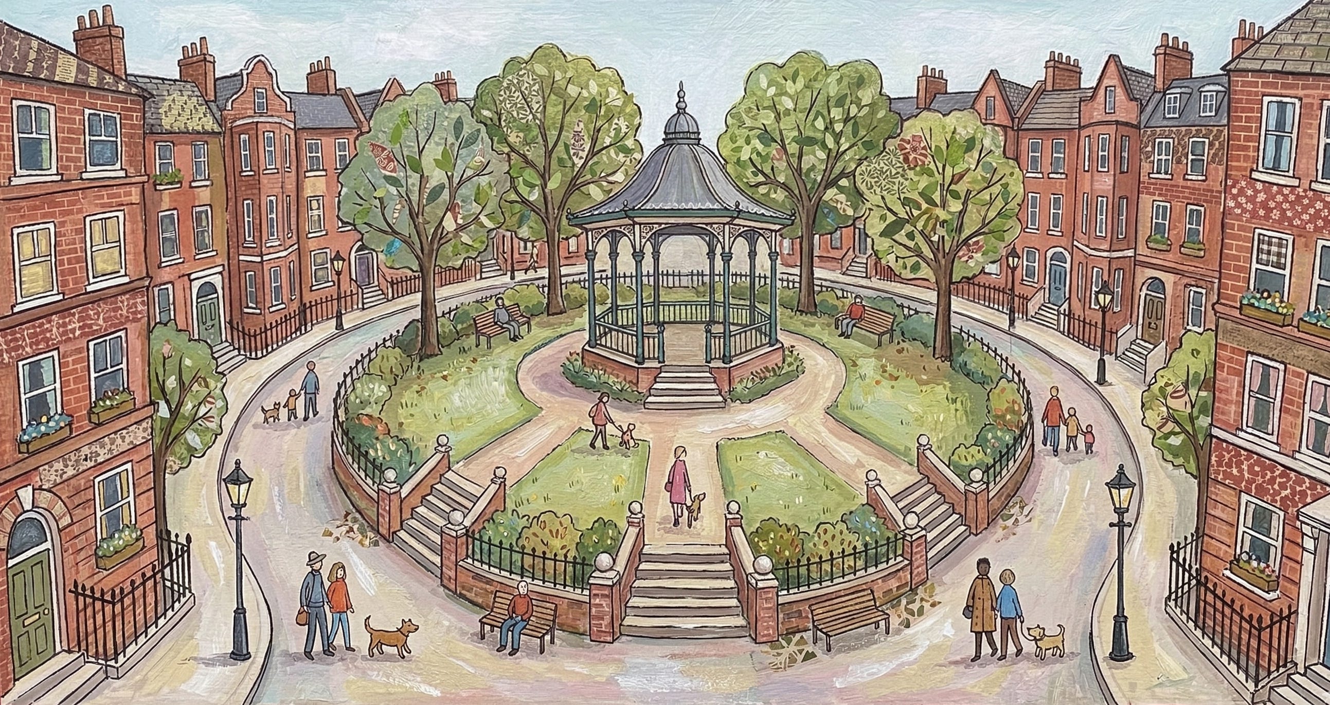
(After I asked you - the reader - to close your eyes and imagine, I got Nano Banana - Google’s AI model - to imagine Arnold Circus above. It’s very Mary Poppins)
The rubble of the demolished slum was used to build the mound at the centre of Arnold Circus. The bandstand went on top. On 8 March 1900, the Prince of Wales officially opened the estate, citing Arthur Morrison’s novel A Child of the Jago - the bestselling fictionalisation of life in the Nichol that Reverend Osborne Jay had commissioned to build public support for the clearance. The fiction had done its work. The Prince praised Jay as “that most excellent philanthropist.” Nobody mentioned the 5719 people who had been moved on so that he could stand there.
The new tenants were clerks, policemen, cigarmakers and nurses. They were the deserving poor - the Victorians were very particular about the distinction. The estate was dry: no pubs, no shops selling alcohol. The rules for tenants ran to fourteen items, including a requirement to wash the communal staircase daily. Sobriety and cleanliness were enforced. The old Nichol residents, classified in Booth’s own survey as vicious, semi-criminal, were not invited.
Of the nearly six thousand people displaced from the Old Nichol, exactly eleven families from the original slum were given one of the new flats.
Eleven.
The architects had misjudged what the slum’s residents would be able to afford. The rents, set as low as possible, were still higher than they had been paying. The poorest simply could not qualify. Charles Booth, the man whose map had made the whole project possible, watched this outcome and was appalled. He wrote: “Thus, although the council managed the estate efficiently it failed to assist those who needed decent housing the most.”
The man who painted the streets black had not intended this. Once Booth had seen the data and changed his opinions, his map was meant to make the poor visible - to force the comfortable classes to confront what was happening in the streets they never visited. Instead, it had made those streets legible enough to be cleared, and the people in them legible enough to be categorised, judged and found undeserving.
The project that never ended
This is the thing that makes the story of the Booth maps more than Victorian curiosity. The mechanism it set in motion - see the poor, map the poor, clear the poor, replace them with someone more respectable - did not stop in 1900. It did not stop in 1945. It is not finished now.
The Boundary Estate itself is a case in point. Two-thirds of it remains council-owned, which is remarkable survival. But the private third has followed the usual trajectory: the red-brick Arts and Crafts flats that were built to house the deserving working class are now among the most sought-after addresses in Shoreditch, one of the most expensive postcodes in Britain. The proximity to Brick Lane, Columbia Road market and Shoreditch High Street makes them, in the language of those estate agents’ particulars, extremely desirable. The original purpose has been entirely inverted.
And Arnold Circus is still there. The bandstand still plays on summer weekends. People sit on the grass and read and eat and watch their children. It is, genuinely, a lovely place.
It is built on a mound of rubble.
Charles Booth set out to count the poor and ended up, despite himself, providing the paperwork for their dispersal. The reformers who used his data were not cynics. Most believed, sincerely, that they were doing good. That is perhaps the most disturbing part. The road to Arnold Circus was paved with the best of intentions, and six thousand people walked it in the wrong direction.
Next time you visit - and it is worth visiting - stand on the mound for a moment. Look at the bandstand, the avenues, the handsome brick. Then think about what’s under your feet.
Notes
The Booth poverty maps are freely available to explore at booth.lse.ac.uk . You can compare the original 1889 street classifications with modern maps of London.
Sarah Wise’s book The Blackest Streets: The Life and Death of a Victorian Slum is the definitive account of the Old Nichol and is essential reading.
It’s not all bad news. The scandal of evicting people and not caring where they ended up next, stopped with the Boundary Estate. The newly-formed LCC realised this wasn’t at all a fair thing to do. In future schemes, a thought was made about the rehousing of those displaced.
I have no idea if videographer Jago Hazzard gets his first name from A Child of the Jago - Arthur Morrison’s novel about the Old Nichol? ‘The Jago’ was Morrison’s fictional name for the Old Nichol slum itself, not a person. He needed to disguise the location slightly, so he renamed the neighbourhood after a real criminal family - the Jagos - who had actually lived there. The name stuck so effectively that people started calling the area “the Jago” in real life, even though it had always been called the Old Nichol officially. The real Jago family were a notorious Shoreditch criminal dynasty, exactly the kind of inhabitants Booth would have painted black. Morrison used their name as shorthand for everything the slum represented - inherited criminality, no escape, identity determined by birthplace.
It’s worth a mention that Morrison borrowed a real family’s name for his fictional slum. It adds another layer to how the fiction and reality became entangled, to the point where the Prince of Wales was citing a novel at the opening ceremony of an estate built on the homes of the people that a novel had helped condemn.
Very interesting article. My dad once had one of the workshops. Does anyone remember that brilliant BBC / Open University series 'The Secret History of Our Streets'? Arnold Circus was one of the episodes.
Very informative. I used to pass through the bandstand often and while I knew about The Jago, I didn't know the Charles Booth connection.