

The enigmatic River Effra
Visible on old maps of London; now underground

I’ve been making a bit of progress on the 1862 Stanford map of London.
First of all, you can now use the friendly URL:
www.theundergroundmap.com/1862
to access it. Well, that’s much easier to remember. Just a reminder that I’ve georeferenced this map and put it online on my website. I told the story in my previous post.
In this post I’m going to start with the same map but at another angle of attack.
Tracing the buried River Effra
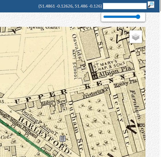
The River Effra - now almost entirely underground - once flowed north from the hills of Upper Norwood and Dulwich to join the Thames near Vauxhall.
I’m going to use the desktop version of the map on my website to show the final course of the River Effra. If you’ve no access to a PC or Mac, don’t fret. I’ll illustrate with maps embedded in this article. Website instructions will be placed into italics which you can skip over if you’re not sitting upstairs at your desk.
Here’s the URL if you are playing along:
www.theundergroundmap.com/article.html?id=4026

The red marker pinpoints the mouth of the river in 1862. Though the Effra is these days completely culverted, some of the outflow still reaches the Thames under the St George Wharf development (which came along in 2001-2010). As an aside, I once stayed in St George Wharf for a week and properties there seem to be mainly owned by folk who are investors. Most of the other windows at night were dark which made for a lonely sort of a stay.
There are other markers on the website map which are clickable. But let’s not do any marker clicking.
The name Effra is of uncertain origin and appears to have been applied to the stream no earlier than the late eighteenth century. Early nineteenth-century gazetteers gave it no name at all, and a map of 1744 calls it simply The Shore. The most plausible explanation, advanced by the Lambeth borough archivist in 2016, is that the name derives from Heathrow, a manor of around 70 acres south of Coldharbour Lane, which by the 1790s had turned into the name Effra Farm.
I can imagine how Londoners can turn Heathrow into Effra. Just drop the h and turn the th into an f sound. I fink that’s ‘ow you do it, any’ows. In another world we’d have Effra Airport.
Above: at any time when the website map isn’t full screen, you can use the slider thing top right to cause the modern Open Street Map to fade in to get our modern whereabouts. Drag it left: OpenStreetMap. Restore it right, 1862 map. In between, a mélange.
There are people who insist Effra derives from Celtic, Latin, Celtic or Anglo-Saxon roots. These hypotheses are now regarded as products of nineteenth-century antiquarianism.
For those playing along, you can make the map full screen by clicking FULLSCREEN MAP at the top. And go back again by pressing Return. I’m agnostic about how you may want to view the map if you are at a PC/Mac.
The history of the course of the River Effra is rather weird. In the medieval period, the lowest reach of the river was flowing to the Thames in Bermondsey not Vauxhall. There were flooding disputes between the monks of Bermondsey Priory and neighbouring landowners.
The way this was resolved was by some clever geological shenanigans in the Kennington area. Before this intervention, the river’s course had run into Walworth Marsh - subsequently drained to become Walworth Common - and into the Earl’s Sluice. After diversion, the lower channel ran directly west from Kennington to the Thames at Vauxhall. John Ogilby’s ‘Britannia’ of 1675 referred to this northern stretch as the ‘New River.’ This made flooding an issue in Vauxhall instead but those wistfully wanting to dig up the Effra and make it flow as it once did should remember it didn’t come this way originally at all.
On the 1862 map, following the river upstream from its Vauxhall mouth and it disappears into non-existence at Vauxhall Cross.
Let’s change the map.
Click that ‘piles of paper’ control top right and then click next to 1830

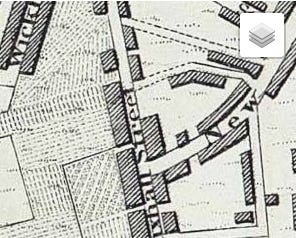
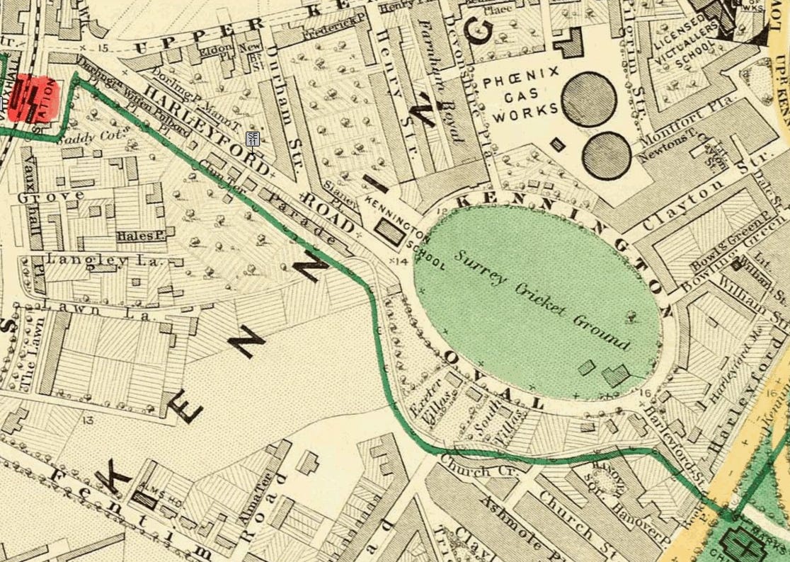
The 1830 mapping (actually the 1829 Greenwood map) shows the River Effra still above ground. From Vauxhall Cross in a London yet without railways the river runs in a channel in front of a road called Vauxhall Place before turns sharp east at a house called The Hermitage and up to the Oval.
The arrival of Vauxhall station helped the culverting effort to happen - i.e. the lack of a river you see on the 1862 map. The railway bridge over South Lambeth Place had had a river in the way.
Vauxhall Place was demolished and absorbed into South Lambeth Road in due course. On South Lambeth Road is the building of the British Interplanetary Society. Go into their basement and you can hear a gushing sound from somewhere.
The Hermitage corner became Lawn Lane and the river in 1830 was flowing across open fields to the Oval. Now it’s under but just to the north of Lawn Lane, SW8.
Drag the (1830) map so that the Oval is in the centre.
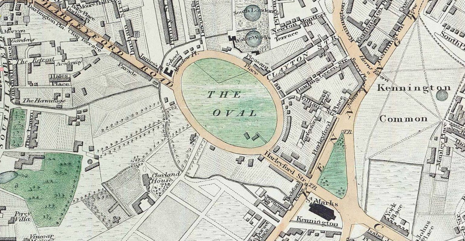
A tiny tributary starts at the South London Water Works north of the Oval. The water works became the gas works on the same footprint and gave us cricket’s Gas Works End.
By 1829, the Oval had been separated from Kennington Common by its royal landowner - the Duchy of Cornwall. There was a surrounding road around the new oval-shaped area which was built to attract development.
South of the Oval, the meandering course of the River Effra is visible. This flows past St Marks Kennington church but then at the top of Brixton Road disappears back into a culvert under the new suburb of North Brixton.

The Effra reappears curving around market gardens - that distinct meandering shape - but Substack is warning me that this article is ‘nearly too long for email’. So that’s a map tale for another day.
But as a text summary:
The Effra was fed by several tributaries meeting above Brixton. The main branch rose near Harold Road in Upper Norwood Recreation Ground and flowed through West Norwood. A second branch rose south of Gipsy Hill, running via Croxted Road into West Dulwich. Springs in Dulwich Wood fed a branch through Belair Park to Herne Hill, while a tributary called the Ambrook rose in Sydenham Hill Wood and passed through Dulwich Park, where its landscaped channel remains visible. The longest and most easterly tributary ran from Eliot Bank and Horniman Park in Forest Hill.
Until around 1850, the stretch of Brixton Road that followed the stream’s course was known as the ‘Washway’ By that time, increasing development had made it heavily polluted with domestic waste, and by 1821 it was classified as an open sewer below North Brixton. Repeated flooding caused residents of Brixton Road and South Lambeth to complain of inundated houses. In 1847 the Surrey and East Kent Sewers commissioners, under surveyor Joseph Gwilt, culverted the Effra as far upstream as Herne Hill.
When Joseph Bazalgette designed London’s sewerage system in the mid-nineteenth century, he incorporated the Effra into its southern division. The Effra Branch Sewer, some three miles long and costing around £19 400, carried much of the river’s surface water from the Norwood area to join the Southern High Level Sewer at Croxted Lane.
The Southern High Level ran eastward under Peckham and New Cross to Deptford, where it joined the Southern Low Level Sewer. Together they formed the Southern Outfall Sewer, running beneath Greenwich and Woolwich to Crossness.
A pumping station was built in 1897 near the point where the Effra Culvert intercepted the Southern Low Level Sewer, necessitated by flooding in the low-lying lands of Battersea and Vauxhall.
The construction of the Thames Tideway Tunnel in the 2020s brought further changes to the river’s outfall arrangements. An interception chamber was built into the Thames at Albert Embankment to divert overflow into the Tideway Tunnel, with a new outfall retained for use during sewer surges. The top of the chamber was landscaped for public access and is now known as the Isle of Effra.
But the map nerd in me wants to revisit the Oval and damn the Substack email warning. Back to the 1830 and we had:
The Effra is clearly visible.
Knowing the 1830s course of the Effra we can spot it on the 1860s map. It’s just that on the Edward Stanford map it is nearly invisible - so I took a cartographic diversion. It re-emerges from its Vauxhall Cross culvert at Langley Lane, turns the same corner at Lawn Lane and then follows the administrative boundary. Church Crescent (long gone) and Hanover Gardens (still here) trace the winding course of the culverted river. But hard to see on the map.
Surrey Cricket Ground - the new tenant - made a no-doubt pleasant-to-see use of the open field of The Oval. Then they built grandstands and it was ‘goodbye green view’.
Notes
The Duchy of Cornwall - a.k.a. Prince William at time of writing - still owns the Oval. This is why there are little fleurs-de-lis everywhere on the ground.
My rendering of the 1862 Stanford Map of London is very much a work in progress. It’s well dodgy on a mobile phone. The slider thingy is temperamental too. I’m using AI Anthropic Claude code to help me fix my original 2015 programming but it’s finding my ten years ago effort a bit of a challenge even so. I did know how to use JavaScript once upon a time. And I’m now too lazy to stare at code myself when AI can sometimes do it better.
There's an Effra Road in Wimbledon. (I know because I live on it.) Which is odd, because we're nowhere near the Effra. We're quite close to the Wandle, but that's not at all the same thing.
Nice trip down memory lane for this former Sarf Lunnon resident - lived in Croxted Road, which is mentioned here.