


The 1879 Royal Agricultural Society show
Washout summers were a Victorian phenomenon too

The 1879 Royal Agricultural Society of England’s annual show was held in an area which later became Queen’s Park. That’s Queen’s Park the actual park and not Queen’s Park the suburb, though there was some overlap of land.
By all reports, the show was bloody awful. Wet, miserable…
Queen’s Park main line station was ready to serve the show - opened on 2 June 1879 on the London & North Western Railway main line and just in time to facilitate the movement of heavy machinery and stock. Prior to the opening, there was very little development here to justify a station. LNWR trains just sped on through the area on their way between London and Birmingham.
The Church Commissioners - who owned the land - convinced The Royal Agricultural Society of England to host their 1879 event here, and then the LNWR to open a station in time for the potential attendees to be served. With a new station, builders would follow and the Commissioners could watch the leaseholder cash roll into their coffers.
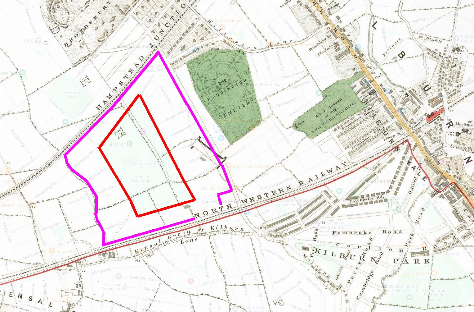
The 1860s map above shows a purple line around the fields which hosted the show and a red line around the future Queen’s Park. Queen’s Park station would go where the H of North Western Railway is written - on Salusbury Road.
The show was opened on 30 June 1879 by the Prince and Princess of Wales.
By the 1870s, the annual Royal Agricultural Society shows had developed into significant occasions, with the 1879 show becoming the largest ever organised. It featured 11,878 implements and 2879 livestock entries.
International exhibitors were well represented, and a Royal Box formed part of an arena with seating for 3000 people, where prize-winning cattle and horses were paraded daily.
The Royal Agricultural Society of England had been established in 1838, aimed to advance agricultural productivity through scientific methods. The Society organised the shows in different regions of England, regarding these as vital platforms for disseminating agricultural knowledge and introducing farmers to new techniques and improved farming practices.
The relative agricultural prosperity of the third quarter of the nineteenth century led to the shows taking on the character of agricultural carnivals or festival occasions.
The streets of the host towns would typically be decorated and festooned with banners proclaiming ’Peace and Prosperity’ and ’Success to Agriculture’.
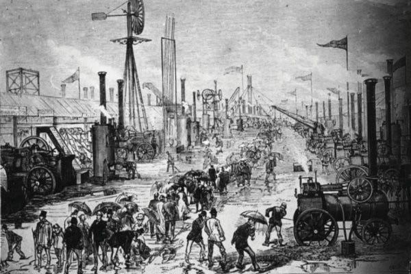
Though it attracted more than 187 000 visitors, the 1879 ‘Kilburn Show’, took place during one of the wettest summers on record. Because of this, the showground presented a ’thoroughly wet and dreary appearance’. The Society made a substantial financial loss on the event - £15 000 - and twenty-three years later Joseph Darby recalled that:
... everyone who visited Kilburn retains vivid recollections of its excessive downpours; of the planks laid down the leading avenues and without which they would have been perfectly impassable... one man slipped and falling between two of the planks was so tightly wedged that it was difficult to pull him out.
The show ran for a week but the poor weather meant people had to struggle through deep mud and attendances fell disastrously short of the plan.
The visit by Queen Victoria on the fifth day boosted numbers significantly, with nearly half of all visitors attending that day. The Queen travelled along a purpose-built path of ballast and brick from the new station via Salusbury Road, greeted by crowds of cheering spectators lining the route.
After the 1879 show had finished, a 30 acre park called Queen's Park was created when the Church Commissioners donated land to the Corporation of London. This is the reason that the Corporation of London manages it, way out of their usual geographical remit. The remodelled park opened in 1887, Queen Victoria’s Jubilee Year but this isn’t the reason the name Queen’s Park came to be.
The Queen's Park Estate lay to the south west of the new station. It was built from 1874 by the Artisans, Labourers & General Dwellings Company as a model ‘improving’ community (i.e. no pubs but a grand library). The architecture of that estate of some 2000 small houses is distinctively Gothic-revival, with polychrome brickwork, pinnacles and turrets along the bigger roads.
North-south thoroughfares were named First Avenue, Second Avenue etc up to Sixth Avenue. Originally the east-west street were named A-P but this proved even too dull for the Artisans, Labourers & General Dwellings Company. The street names were then made into full words, (Alperton Street, Barfett Street, Caird Street, Droop Street, Embrook Street, Farrant Street, Galton Street, Huxley Street, Ilbert Street, Kilravock Street, Lothrop Street, Marne Street, Nutbourne Street, Oliphant Street, Peach Street).
Importantly, the ‘Queen’s Park’ name came from the name of this estate and was nothing to do with later jubilees or parks.
North of the LNWR, the suburb now simply called Queen’s Park (i.e. not the ‘Queen’s Park Estate’) was developed by Solomon Barnett.
The two-storey terraced houses east of the park were built between 1895 and 1900 and typically have clean, classical lines.
Those west of the park, built 1900–05, tend to be more Gothic in style.
Solomon Barnett’s wife was from the West Country and was given the job of naming the roads. Many of the roads developed are named for places she knew as a child - Torbay, Tiverton, Honiton - or for poets she liked, such as Tennyson.
To complete the development story around the station, the suburb of ‘Kilburn Park’ to the southeast was developed from the 1850s onwards.

On Ilbert Street, the ‘I’ road of the Queens Park Estate still lies the St Jude's Institute. They had a football team which merged in 1886 with Christchurch Rangers - the latter team formed in 1882.
The resulting team was called Queen's Park Rangers. Most of the original players came from the Queen's Park area.
The team went a-wandering and QPR played their home games in just about 20 different locations before permanently settling at Loftus Road in Shepherds Bush in 1917. This is why this W12 team has the name of an NW6 suburb.
Since I’m writing the story here I’ll go on, since I have no home otherwise for the following piece of trivia.
What eventually became the suburb of Queen’s Park formed part of the parish of Willesden and the southern section (the Queen’s Park Estate) formed an exclave of the parish of Chelsea, both in the Ossulstone hundred of Middlesex.
In 1889 the area of the Metropolitan Board of Works that included the southern section was transferred from Middlesex to the County of London, and in 1900 the anomaly of being administered from Chelsea was removed when the exclave was united with the parish of Paddington. In 1965 both parts of Queen’s Park became part of Greater London but were split up again: the northern section - Queen’s Park ’proper’ formed part of Brent (London NW6) and the southern section - the Queen’s Park Estate - joined the City of Westminster (London W10).
NOTES
Once the annual Royal Agricultural Show moved to Park Royal, that suburb also got its name. The Royal Agricultural Society of England had planned to make the Park Royal site a permanent home for the show. But it was not a success and the Society sold the land in 1907. Two London suburbs thus owe their history to the same annual event.
Services on the Bakerloo line were extended from Kilburn Park to Queen’s Park on 11 February 1915. On 10 May 1915 Bakerloo services began to operate north of Queen’s Park as far as Willesden Junction over the recently built Watford DC Line tracks shared with the LNWR.
Interesting article. Many thanks.
You mention that "after the 1879 show had finished, a 30 acre park called Queen's Park was created when the Church Commissioners donated land to the Corporation of London." So, was it named to commemorate Queen Victoria's visit to the park, and is it still maintained by the City of London as one of their open spaces?