Before I get onto the maps, a word or two about the station.
Stepney Green station is a delightful art nouveau experience down on the platforms with beautiful green and white columns dating from 1902.
The station was originally opened by the Whitechapel and Bow Railway. This was a joint venture between the District Railway and the London, Tilbury & Southend Railway.
District Railway Services started in 1905 and then Hammersmith & City line services - then part of the Metropolitan Railway - started in 1936.
The Mile End Road, on which the station stands, was originally part of the London to Colchester Road. This was once known as the Great Essex Road which reflected its destination
The term Mile End was recorded as early as 1288 and the mile distance was related to the distance as measured from Aldgate.
The mile end marker stood at the intersection where Cambridge Heath Road meets Whitechapel Road. There was a turnpike gate here.
Traders who travelled long distances to sell their goods in the City would pass through this gate. They would then park their wagons on the wide thoroughfare of Mile End Road, ensuring their safety overnight. These traders typically spent the night at one of Whitechapel's taverns before rising early to complete their journey into London the following morning.
One of the earliest suburbs of London was called Mile End Old Town, situated beyond the turnpike gate.
It’s maybe time for the first map to get our bearings.
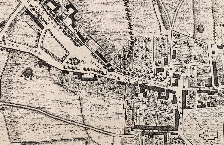
The turnpike gate can be seen as a dotted line on Mile End Road at the far left between an O and an L on the map. It stands at the end of Dog Row (now Cambridge Heath Road).
On the south side of the Mile End Road, east of the turnpike is a house behind a front yard. This was Captain James Cook’s house, one of the early residents of the new suburb. This is now numbered 88 Mile End Road. Opposite his house were the Trinity Green Almshouses. These were built in 1695 andintended for "decay'd Masters & Commanders."
A couple of fields are opposite Camel Row before a turning into Mile End Green (with this road confusingly called Mile End Old Town). Mile End Green was an area of common land.
The fields of Mile End Green were known as the Mile End Waste. This was the site where William Booth preached against the dangers of alcohol in the 19th century. His sermons there led to the founding of the Salvation Army, an organisation dedicated to helping the poor and destitute who gathered in the area. Booth's statue, created by George E. Wade in 1927, stands outside Trinity Green Almshouses.
The Mile End Waste had long been used for political and religious meetings and gatherings. The Essex part of the Peasants’ Revolt met here just before they gathered to move onto London itself.
Opposite the turning into Mile End Green, on the north side of Mile End Road, down a lane, is Westfield’s Brew House beside a pond. The Rocque map is great for long lost names of London. We passed Camel Row and down the lane leading to Mile End Green are The 13 Houses.
As we travel east along Mile End Road, we pass the White Horse Inn which lent its name to White Horse Lane, which still exists.
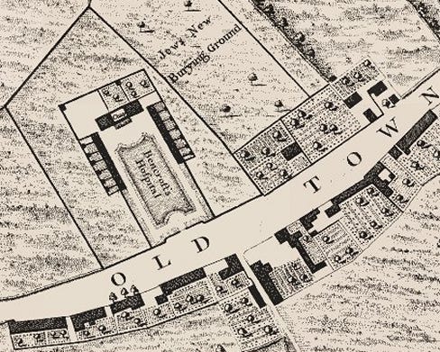
North of Mile End Road is the Jews Old Burying Ground. This was established in 1657 and was the first Jewish cemetery in the whole of Britain after Oliver Cromwell allowed Jews back into the country. They had been expelled 267 years earlier by Edward I.
The 1657 burial place gave rise to Mile End Old Town. The area was largely Jewish by the time the suburb was officially recognised in 1690.
Our Rocque map extract continues past Bencroft’s Hospital (almshouses) and the Jews New Burying Ground. The People’s Palace would later be built on the site of the former, and Queen Mary’s in time would surround the latter.
There has been a lot of ‘Mile End’ in this story of Stepney Green. The coming of the underground railway changed nomenclature. Mile End station was built at the Burdett Road junction and that area became called Mile End, well over a mile again from the original Mile End Turnpike. The area I have been describing became Stepney Green.
This happened in two stages.
Historically, Stepney was a very large ancient parish which covered most of what would become the East End. The rapid growth in population meant that over time the parish was broken up.
Hackney became independent in the 12th century, Whitechapel in the 14th and Bromley in the 16th. Bethnal Green, Bow and Poplar are known to have been based on pre-existing hamlets and formed new daughter parishes.
The name Stepney Green came about as houses were built in the 15th century beside St Dunstan’s Stepney Church. The street of houses here was called Stepney Green. In local usage, Stepney Green took over the name Mile End Green before the turn of the nineteenth century. This was then compounded by the arrival of Stepney Green station in 1902.
Seventy years passed between the John Rocque map and Greenwood’s map of 1829.
There is still a good deal of open space but also a lot of urbanisation.
The Stepney Green name has appeared.
The top of White Horse Lane is temporarily called George Street and an area to the east of it was built up just after the Napoleonic Wars. These streets are named in the repetitive 19th century style - John Street, Alfred Street, Henry Street. But there’s a Trafalgar Square here too. As this caused confusion with its West End counterpart, this became Trafalgar Gardens in time, even though this Trafalgar Square had been first on the scene.
The fields of Stepney Green (the former Mile End Waste) have been built over but houses along Mile End Road here are called Assembly Row in a nod to the previous history.
A continuing Jewish presence in the area has caused more cemeteries to be laid out.
The urbanisation of the area was part-driven by the maritime trades along the river, as well as ribbon development along the Mile End Road. By the 1860s it was complete.
The origin of Charrington’s Anchor Brewery can be seen where the brewhouse had been.
Mile End Place was built for Charrington Brewery workers, east of White Horse Lane. This was situated amongst three of the Jewish cemeteries and opposite a Jewish hospital. A kink built into Mile End Place means that Mile End Road cannot be seen from the cul-de-sac of cottages here, even today leaving a rural atmosphere
Industry has arrived elsewhere - the bottom right of the map sees the Commercial Gas Works in operation.
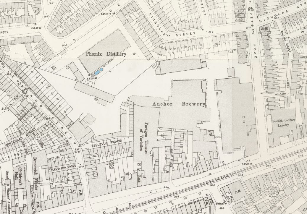
To see any detail on the 1890s Ordnance Survey, we have already zoomed in on the map above but we need to zoom in somewhat more.
The Tower Hamlet's Mission, beside the now-large Anchor Brewery was established in 1870 by Frederick Charrington. He was a member of the family who had a rush of guilt about the effects of alcohol upon the poor. William Booth - mentioned earlier - had been active at the same time.
Just to the east of the Paragon Theatre of Varieties (later a cinema) is a row of shops.
The Wickham family originally operated as drapers, conducting their business from 69, 71, and 73 Mile End Road. The adjacent property at No. 75 was occupied by the Spiegelhalter family, who were clockmakers and jewellers. In approximately 1892, the Spiegelhalters agreed with the Wickhams to relocate from No. 75 to 81 Mile End Road, allowing the Wickhams to expand their shop into the newly-vacated space.
Over the course of 35 years, the Wickham family gradually acquired the entire block, except for the Spiegelhalters’ shop at No. 81. Their plan was to extensively renovate and expand their store, and they attempted to purchase the Spiegelhalter property. However, negotiations for a mutually acceptable price failed, resulting in the Spiegelhalters’ shop becoming a holdout.
In the end, the new store was constructed around the Spiegelhalter shop, which continued to operate even as Wickhams opened shops on either side. It was designed by T. Jay Evans & Son and built in 1925-1927. Number 81 Mile End Road - the holdout - can be seen on the 1950s map above.
The design of the Wickhams building was intended to rival Selfridges department store on Oxford Street, featuring a colonnaded front, a central tower, and a clock that Selfridges did not possess.
The contract for the stone façade had been awarded before it became clear that the Spiegelhalters were unwilling to sell. To accommodate this, the right wing of the building was shifted to the right by the width of the Spiegelhalters’ land.
To complete the Stepney Green story we should zoom back out on the 1950s map.
Stepney Green station is now marked on the map with baths built next to it. Before everybody had inside bathrooms, public baths were popular in London.
A lot of the earlier side streets of Stepney Green had disappeared by 1950. There are gaps in the streetscape where buildings along roads finish and restart. This was the effect of bomb damage during the Blitz.
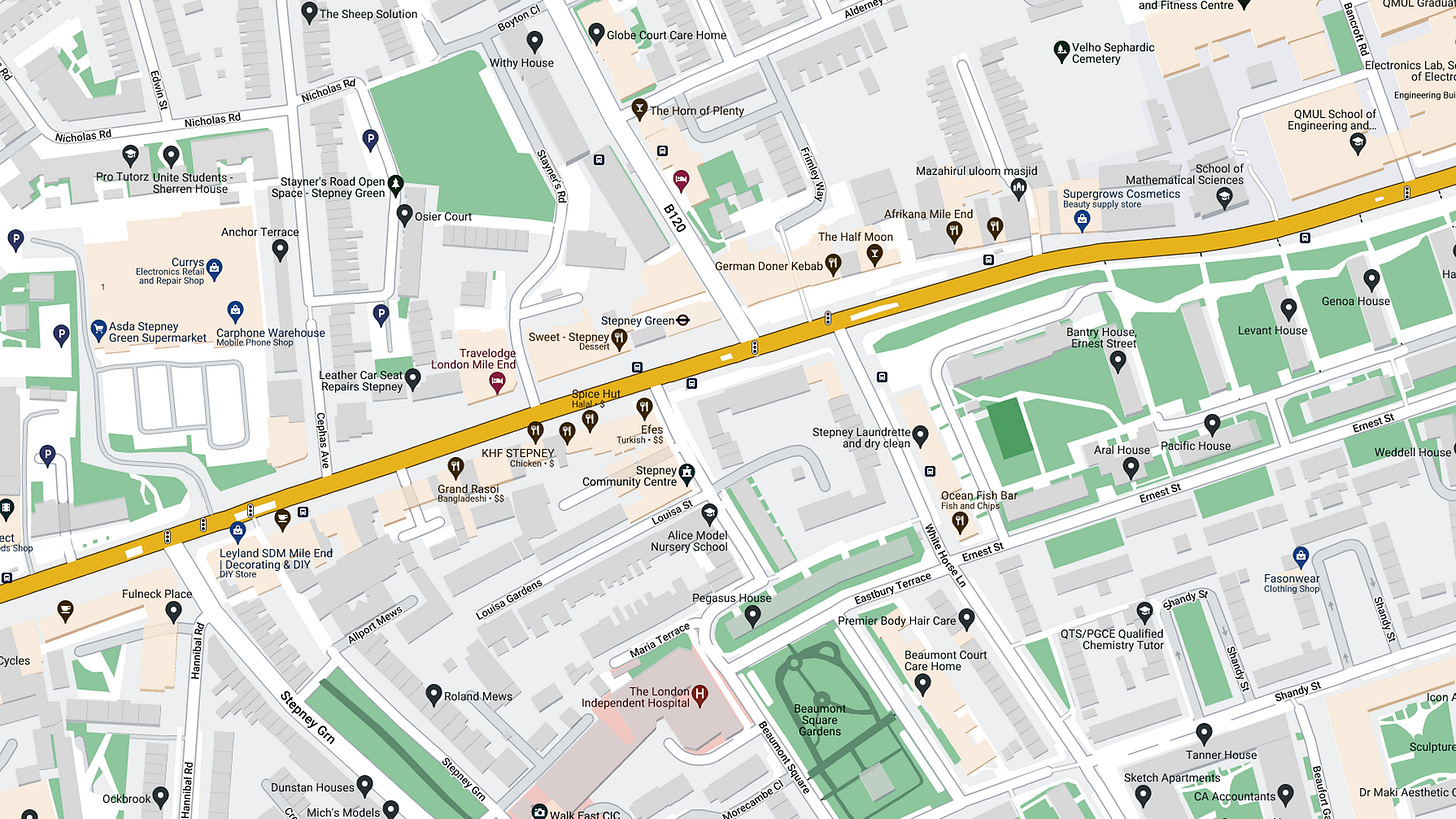
Nowadays, the Ocean Estate is on the map, opposite the entrance to Mile End Place, on the site of the Jewish Hospital and many bombed streets.
A huge shopping centre has replaced the Anchor Brewery.
There are many other changes but I’ll return to those another day.
Just a quick aside here, but a new feature will soon be rolled out to paid Substack subscribers. You will soon be able to request histories of your area of London. Stepney Green is here: www.theundergroundmap.com/pdf/32759/32759-21788.pdf
I walked between Stepney Green station and Whitechapel through the landscape of the maps above. I videoed the result, which can be clicked below.


New weekly feature on Jewish History!! https://substack.com/home/post/p-146575771?source=queue 🔯
Fascinating! My 8th great grandfather, Rev. Matthew Mead, 1629-1699 was an Independent Minister in Stepney . One of his sons was Dr Richard Mead/e, Physician to George II and one of the founders of the Foundling Hospital. Great Ormonde Street Hospital now stands on the site of his house.
www.genealogy.com/ffm.m/e/a/Vance--Mead/GENE11-0014.html