

Pimlico
Neat Houses? Tothill? Well, you won't need your passport

Alongside alliteration, Ealing Studios’ Passport to Pimlico were attracted to this particular London suburb as it has a particular London name. Like Soho, it’s just darned unusual.
It sounds a bit Italian perhaps but, E. Cobham Brewer, writing way back when, suggests that Pimlico might have been a person, possibly the proprietor of an establishment renowned for its distinctive ale. He describes Pimlico as a district of popular public gardens and attributes the name to Ben Pimlico, a man famed for his nut-brown ale.
Interestingly, Brewer notes that Ben Pimlico's tea gardens were actually located near Hoxton, with the route to them known as Pimlico Path. This suggests that the current Pimlico area may have borrowed its name from the popularity of this Hoxton destination and likely acquired its unusual name in the late 16th century.
Pimlico had shed its previous names of Ebury and "The Five Fields". In the 16th century the Manor of Ebury, which owned all the land hereabouts, was divided. By 1666, it came into Mary Davies' possession, whose marriage to Sir Thomas Grosvenor brought the land into that family's ownership. Her dowry included 500 acres to the west of what was then the boundary of London. Mary went on to have an utterly miserable life alas.
The Grosvenors got seriously lucky as, to begin with, Pimlico and Belgravia to its north hadn’t great prospects. Indeed the Grosvenors may well be Britain’s all-time most fortunate family. They came into serious wealth by being landowners in the right place at the right time. I’ve used that sentence before in other posts - many of London’s richest families were those who owned land just at the moment when London’s urbanisation spread to their holdings.
As the Grosvenor family were entering the story, Pimlico was just marshy emptiness with two large named areas - Tothill Fields and Neat Houses.
Tothill Fields was an area of Westminster that lay south of St James's Park. "Tothill Fields," says Archer, in his Vestiges of Old London "were, within three centuries, part of a marshy tract of land lying between Millbank and Westminster Abbey, and on which stood a few scattered buildings, some of them the residences of noble personages."
One of its main features was the Tothill Fields Bridewell penitentiary. This was one of the less severe places of incarceration in the capital, as one of the main punishments was not being allowed to talk to other prisoners. Following demolition, its foundations were reused for Westminster Cathedral which now occupies the site.
Otherwise, Tothill was a vast expense of semi-bog, notable in the history of British sport.
Between 1735 and 1752, an area was cleared to become the home venue of the Westminster Cricket Club. The earliest known match there was in August 1735, when Westminster defeated London by 3 wickets.
Tothill Fields is one of many places listed in History of the British Turf where horseracing had been organised and taken place. This ceased after 1798.
Market gardeners acquired land and built homes in Pimlico dubbed Neat Houses. The ‘Neat House Gardens’ behind them were osier beds and market gardens, named after the former Manor of Neyte, which covered about 100 acres and grew various vegetables and fruits. This low-lying, flood-prone area was primarily pastureland until the 16th century, sparsely populated by farmers tending livestock.
Commercial market gardening emerged in the 16th century as communities grew. Following the dissolution of religious houses, residents sought new sources of fresh produce.
Henry Wise, Royal Gardener to Queen Anne, had gardens at Neat Houses. Many gardeners were tenants, farming small plots.
Alehouses and tea gardens also developed and made Neat Houses a popular recreational spot.
Samuel Pepys recorded a visit in his diary:
After the play, we into the house, and spoke with Knipp, who went abroad with us by coach to the Neat Houses in the way to Chelsy; and there, in a box in a tree, we sat and sang, and talked and eat; my wife out of humour, as she always is, when this woman is by.
Diary of Samuel Pepys, 1August 1667
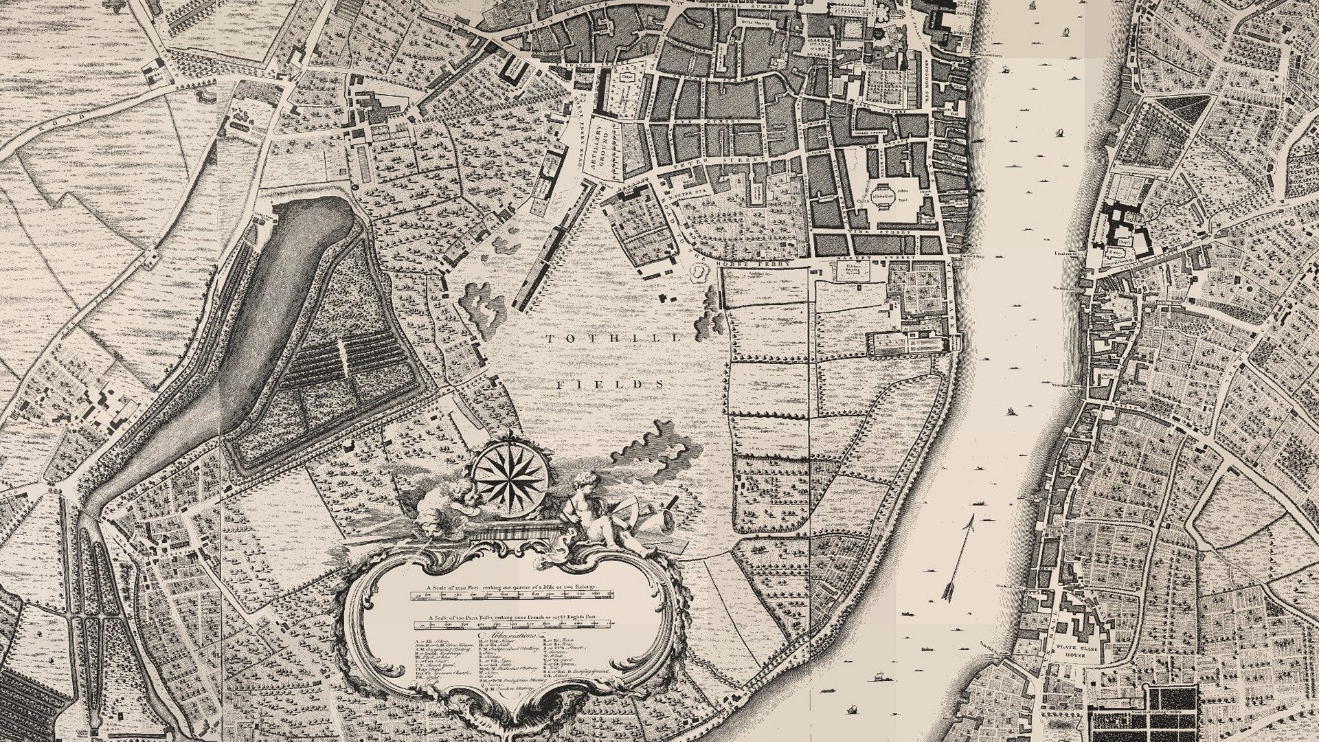
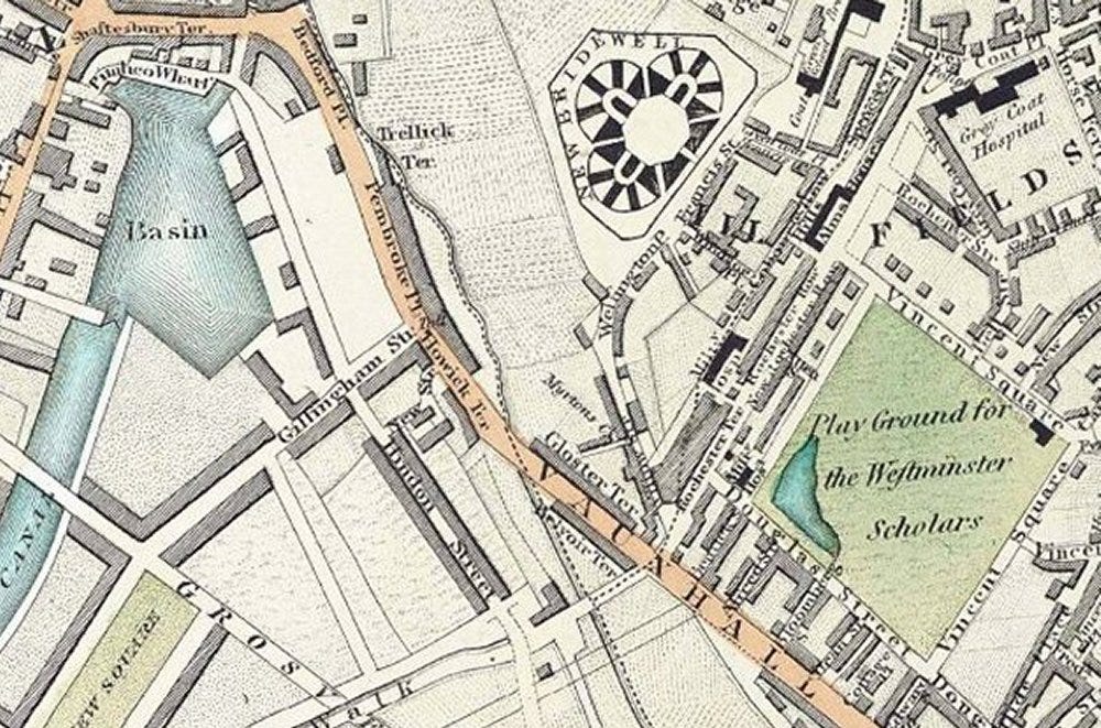
John Rocque's 1746 maps of London offer a wealth of historical detail. The Pimlico area features the Neat House Gardens prominently, spanning an expanse of market gardens depicted with meticulous rows of vegetables. Alas Rocque’s map placed his fancy scale over the top, but small ditches - visible on the map - drained the marshy land. The gardens abruptly end at the northern edge, giving way to pasture.
Rocque's map shows the gardens extending westward along the Thames from near today's Horseferry Road to the current railway bridge. The map also depicts Millbank with scattered houses, possibly some of the ‘Neat Houses’.
Tothill Fields are marked in the centre of the map.
There was a tidal creek marked on the Rocque map and this can also be seen on the 1820s map of the area.
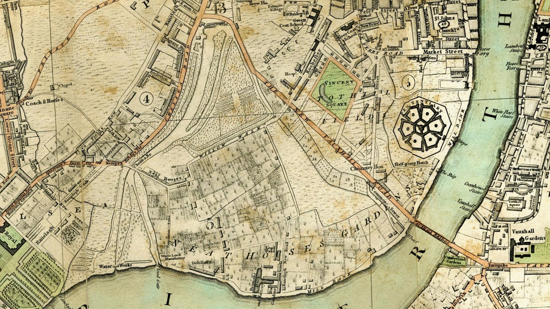
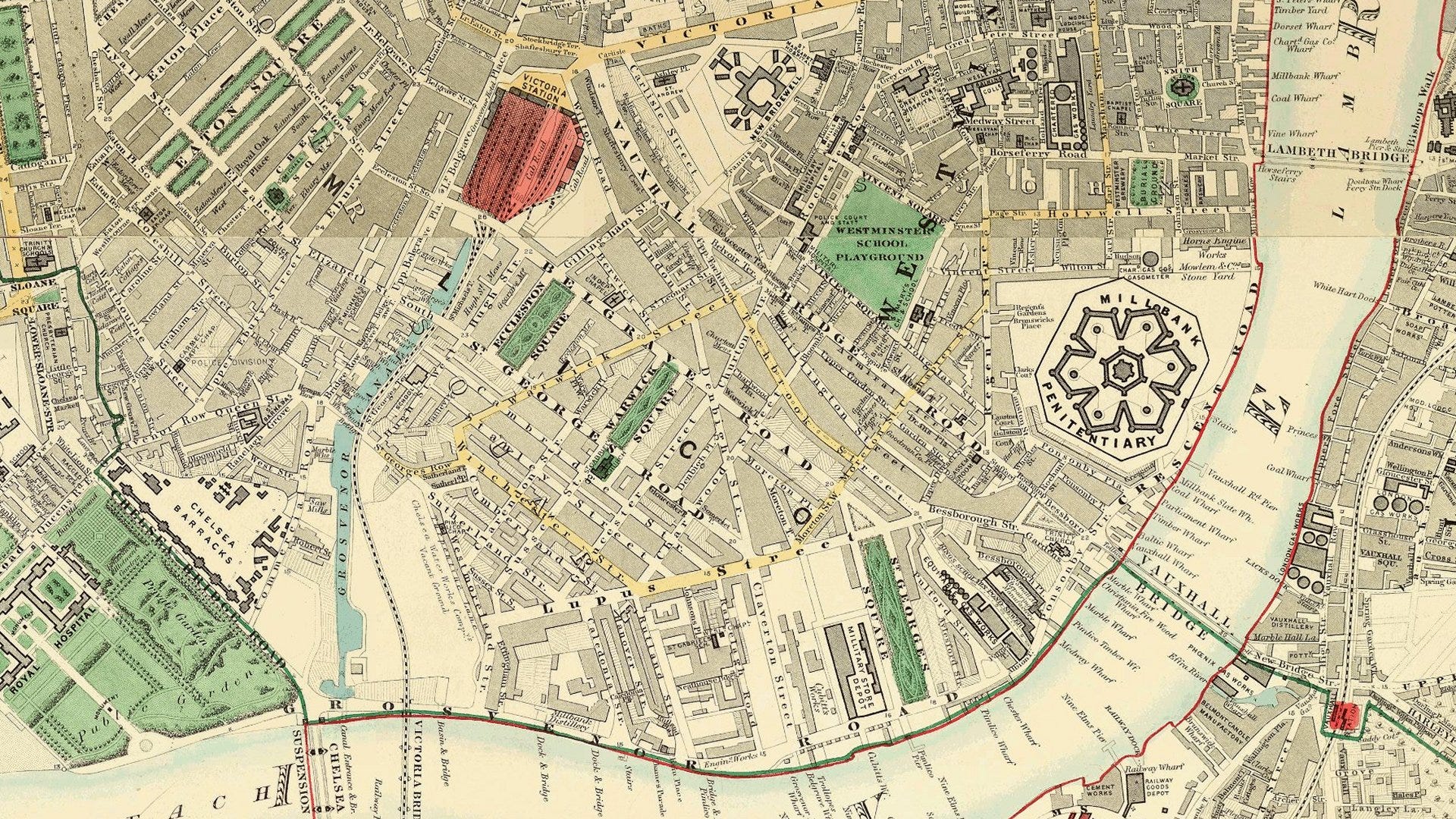
Other developments feature on this 1820s view.
Vauxhall Bridge was built between 1809 and 1816 as part of a scheme for redeveloping the south bank of the Thames. The bridge was built at a location on the river previously served by a ferry. A new road links the northern end of Vauxhall Bridge with Hyde Park Corner (off the map to the north).
Building has spread south from Westminster and Tothill Fields are starting to disappear under bricks and mortar.
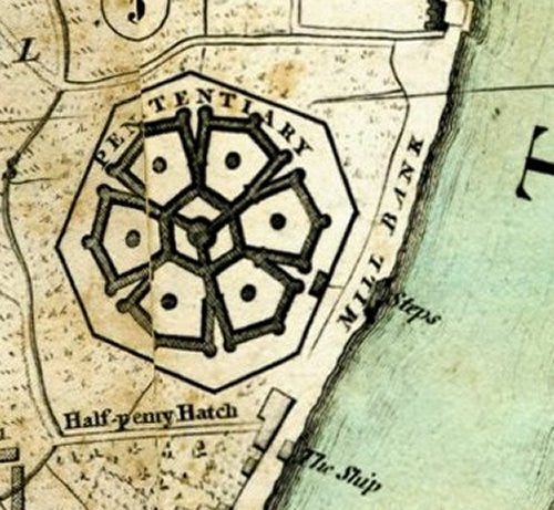
One of the first encroachments on the Neat Houses was Millbank Prison, also known as the Millbank Penitentiary. The prison was opened in 1816 on the later site of Tate Britain and was originally conceived as the ‘National Penitentiary’.
The complex design featured a hexagonal central courtyard surrounded by pentagonal courtyards. These courtyards served as airing-yards where prisoners performed labour. At the three outer angles of each pentagon stood tall circular towers. While these towers functioned partly as watchtowers, their main purpose was to house staircases and water closets.
The prison's design proved problematic. Its maze-like corridors confused even the warders, and the ventilation system inadvertently allowed prisoners to communicate between cells. Annual running costs were unsustainably high and illness was rife due to the marshy location..
These issues led to the construction of a new 'model prison' at Pentonville, which opened in 1842. The Millbank Prison Act 1843 downgraded Millbank's status to a holding depot for convicts awaiting transportation to Australia
Transportation largely ended in 1853, though it continued on a smaller scale until 1867. Millbank then became a local prison and, from 1870, a military prison. It stopped housing inmates by 1886 and closed in 1890.
Moving the map forward by a decade, the Grosvenor Canal, whose name kowtowed to the landowning family, opened in 1824. It replaced the tidal creek and during the 1830s was in its heyday, transporting goods from this area down to the Thames.
During the decade between the maps, Westminster School has bagged a playground in Tothill Fields.
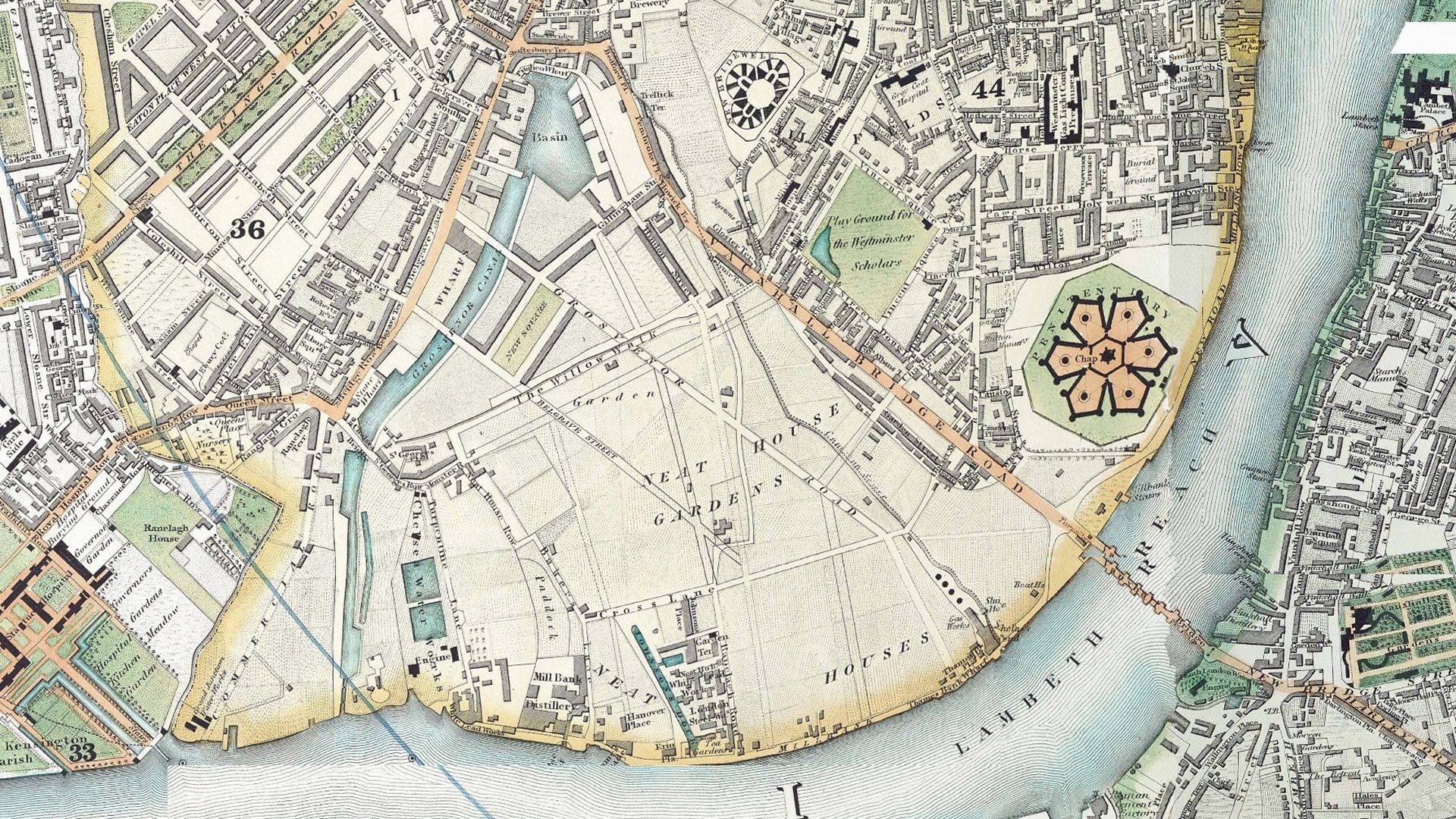
As London's population grew in the early 19th century, pressure mounted on gardeners to sell their land. John Johnson bought the Pimlico lease in 1817 but struggled against the gardeners. In 1825, he sold his lease to Thomas Cubitt.
Neat House Gardens' fate was then sealed. Soon, roads and buildings would replace them entirely and the 1830s map shows the beginnings of the Cubitt plan - the first roads over the site of Neat House Gardens.
Thomas Cubitt’s lease was from the Grosvenor Estate who kept the freehold of most plots built. Cubitt drained the ground, using local clay for bricks and bringing in soil from East End dock excavations to elevate the area above the river.
Pimlico's development was more modest than neighbouring Belgravia, but featured similar architectural styles with tall, stuccoed facades adorned with classical elements. The area's centrepieces, Ecclestone and Warwick Squares, remain largely as Cubitt envisioned them.
Unlike Belgravia's focus on high society - it made the Grosvenors very rich - Pimlico was designed for families. It boasted convenient shopping streets, eateries and well-appointed pubs, contributing to its appeal.
The 1860s map shows the building of Pimlico nearly complete. Pimlico was by then home to the professional middle classes.
The Grosvenor Canal was progressively shortened. The railway terminus at Victoria was built on the canal basin. The railway’s use of the station at first meant lines alongside the canal. But as rail transportation became more popular, more tracks were needed and these were built over the canal. The later Ebury Bridge took more of it away but some of it remained in use until 1995, enabling barges to be loaded with refuse for removal. This made it the last canal in London to operate commercially. A small part of it remains within the Grosvenor Waterside development.
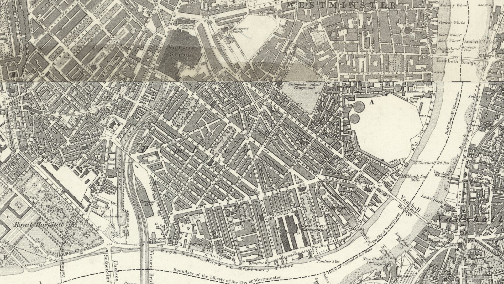
The 1870s Ordnance Survey shows the last of the riverside gaps being built up. Where the prison was, has been marked blank.
As evidenced by Booth's 1889 Map of London Poverty, parts of the district experienced a notable decline later in the nineteenth century.
This shift in the area's social landscape became apparent when Rev Gerald Olivier, father of the future actor Laurence Olivier, relocated his family to Pimlico.
Rev Olivier's move to minister at St Saviour's church was part of a broader initiative to serve in London's western "slums". This venture had previously led the family to reside in the less affluent areas of Notting Hill, highlighting the changing social dynamics of Pimlico.
During the last decade of the 19th century, Pimlico saw the development of several Peabody Estates. These charitable housing projects aimed to provide affordable yet quality homes, reflecting growing concerns about housing conditions for the working classes. The construction of these estates marked a significant shift in the area's residential makeup, introducing purpose-built accommodation for those of more modest means.
Meanwhile, Pimlico’s proximity to Parliament made it a centre of political activity.
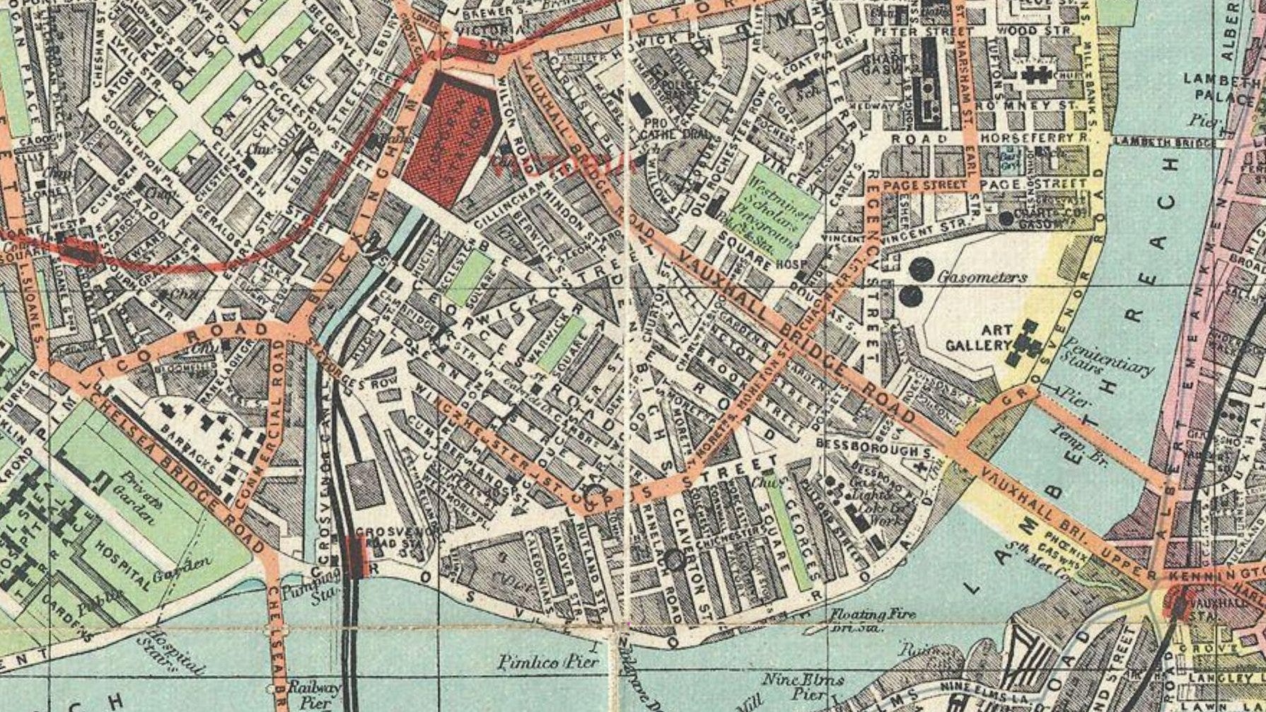
A note of interest on the 1890s map is the appearance of an “Art Gallery” (the future Tate Britain) on part of the site of the prison. Demolition of the Millbank Penitentiary began in 1892 and continued intermittently until 1903.
===
Now that we have reached the twentieth century with our maps, there are not so many changes to see on them.
The area’s story continued but perhaps the detail of that is for a future post. Maybe I’ll solve what Samuel Pepys exactly meant by a “box in a tree”.
Later developments included residential blocks in Pimlico. Dolphin Square, built in the 1930s on Cubitt's former construction site, claimed to be Europe's largest self-contained block of flats and popular with MPs. The Blitz affected Pimlico and, post-war, Churchill Gardens was constructed on a bomb-damaged area.
Pimlico was connected to the Underground in 1972 with its own station on the Victoria line.
Pimlico continued its societal balancing act of rich people and poorer people living in close proximity. It remains one of London’s most endearing suburb names.
Mapping: Ordnance Survey, Rocque, Greenwood and others
Tothill Fields and the 1665 Plague House, called five Chimneys by the 1700's was where several of my family lived from approx 1808 to 1833 when it was demolished. They then moved into the new housing in Garden Street, Dorset Street, Causton Street, Douglas Street etc over the next 50 years and also to Wapping and Horsleydown.
Tothill Fields... is that not where the Torys and the Whigs used to fight pitched battles to decide the outcomes of the parliamentary elections? Would certainly help with voter engagement...