

Leicester Fields
Why Leicester Square is what it is

Civitas Londinum is a bird’s-eye view of the then extent of London, first printed from woodblocks in about 1561. It is widely known as the ‘Agas map’, from a spurious attribution to a surveyor called Ralph Agas.
The map offers a richly-detailed view of the buildings and streets of the city and its surroundings.
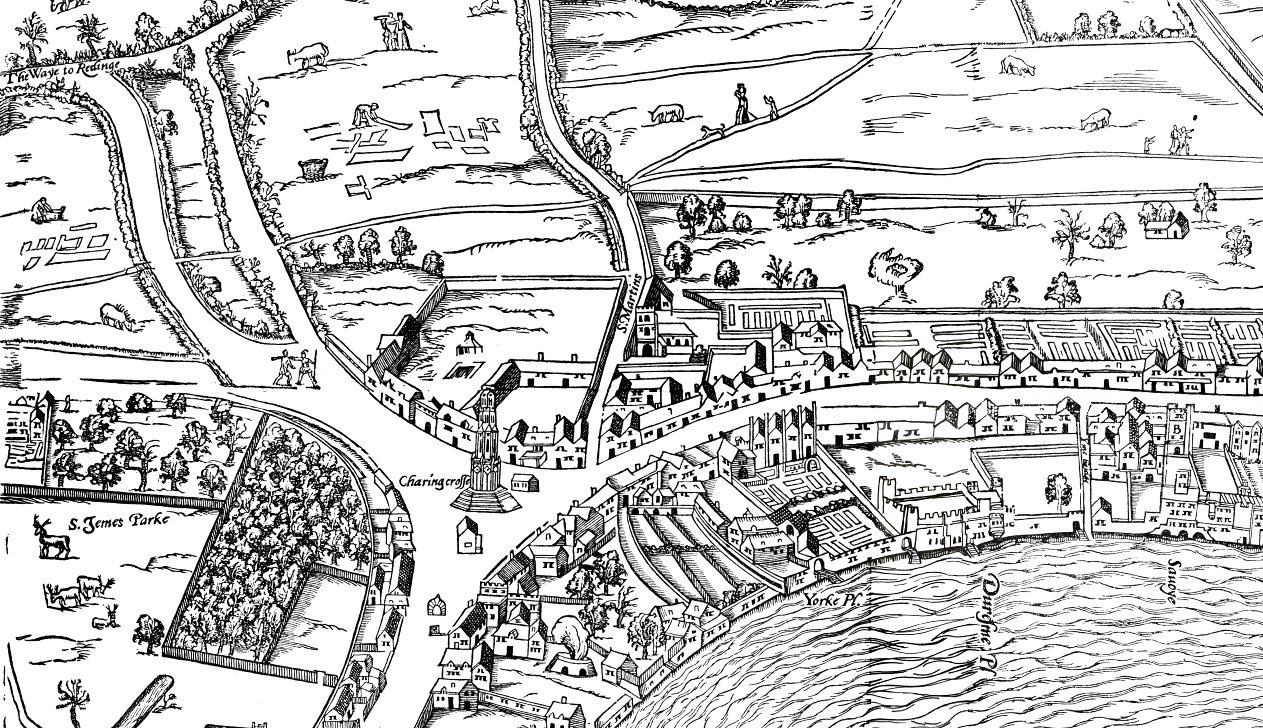
Shown above is the westernmost woodblock. The original Charing Cross - an Eleanor Cross - was erected where Strand, Whitehall and Haymarket met, is positioned nearly at the centre of this map extract.
Strand runs east towards London and is a thoroughfare lined by the houses of the rich, many of them fronting onto the Thames.
Running north is St Martin’s Lane which was the main route north from Charing Cross before Charing Cross Road was built late in the nineteenth century. The church of St Martin-in-the-Fields is visible on the map beside the lane.
Running northwest from Charing Cross is the Haymarket, its then rural nature indicating its name origin.
Immediately behind the Eleanor Cross is the Royal Mews.
The royal hawks were kept in the Royal Mews from 1377 onwards. The name derives from the fact that the hawks were confined there at moulting time (‘mew’ being derived from the French verb muer - to moult).
In 1534, King Henry VIII, decided to rebuild the Charing Cross mews as a stables, the hawks having been given alternative accommodation. It kept its former name when it acquired this new function.
On the Agas map, the Royal Mews can be seen extending back towards the site of today's Leicester Square.
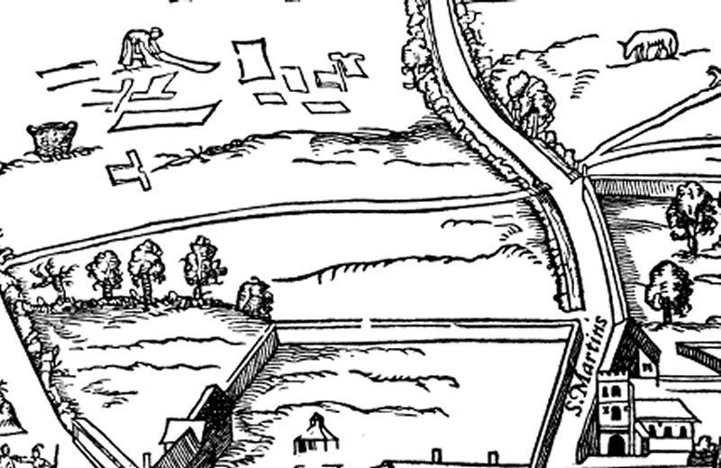
The site of Leicester Square was in 1561, St Martin's Field - the common ground of the Parish of St Martin-in-the-Fields. The land had belonged to the Abbot and Convent of Westminster Abbey and it was a place for St Martin’s parishioners to graze their animals, grow crops on a small scale and, as depicted on the map, dry cloth.
In the late 1530s after the dissolution of the monasteries, Henry VIII took control of the seven acre St Martin’s Field but otherwise did nothing with his purchase, leaving parishioners in peace to continue their use of the land.
The land ownership descended to King Charles I who, with London’s urban area creeping ever nearer, decided to cash in. He sold the field to Robert Sidney in 1630. Robert Sidney happened to be the rich and influential 2nd Earl of Leicester and decided that he needed a large country house near London. By 1635, he had built himself Leicester House, at the northern end of his land.
Sidney enclosed the land in front of the house and barred St Martin’s parishioners from using what previously had been their common ground.
It was usual for the powerful to roll over the long-established rights of mere peasants. But, with loins girded, the locals sought King Charles intervention. King Charles evidently showed some interest in what had previously been his own land. Unusually, he delegated three privy councillors to mediate and obviously had a ‘quiet word’. Their ruling compelled Leicester to maintain a portion of his property, later called Leicester Fields, accessible to the parish community and in perpetuity.
This single legal ruling dictated the subsequent history of Leicester Square.
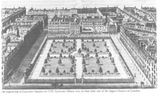
Leicester Fields remained on the edge of the urban area but forty years later, London had overtaken it. The surrounding area was developed in the 1670s. It was initially fashionable - Leicester House was for a while the eighteenth century residence of Frederick, Prince of Wales.
At the end of the 17th century, Philip Sidney, 3rd Earl of Leicester, allowed a small amount of retail development in booths along the front of Leicester House.
The covenant to keep Leicester Fields public meant that it began to serve as a venue for popular entertainments since the parishioners rural needs were long past. Buildings surrounded the field on all sides and it began to be called Leicester Square.
By the late 18th century, the Square was no longer a smart address and Leicester House, leased out by the family, became home of a museum of natural curiosities called the Holophusikon.
Sir Ashton Lever opened the Holophusikon, also known as the Leverian Museum, in Leicester House in 1775. The Leverian collection was a compilation of natural history and ethnographic artefacts and especially renowned for its acquisitions from Captain James Cook's voyages.
Lever transformed Leicester House’s first-floor rooms into a spacious gallery. He showcased roughly 25 000 items valued at over £40 000. The museum's name reflected its purported comprehensive coverage of natural history, essentially serving as an extensive cabinet of curiosities.
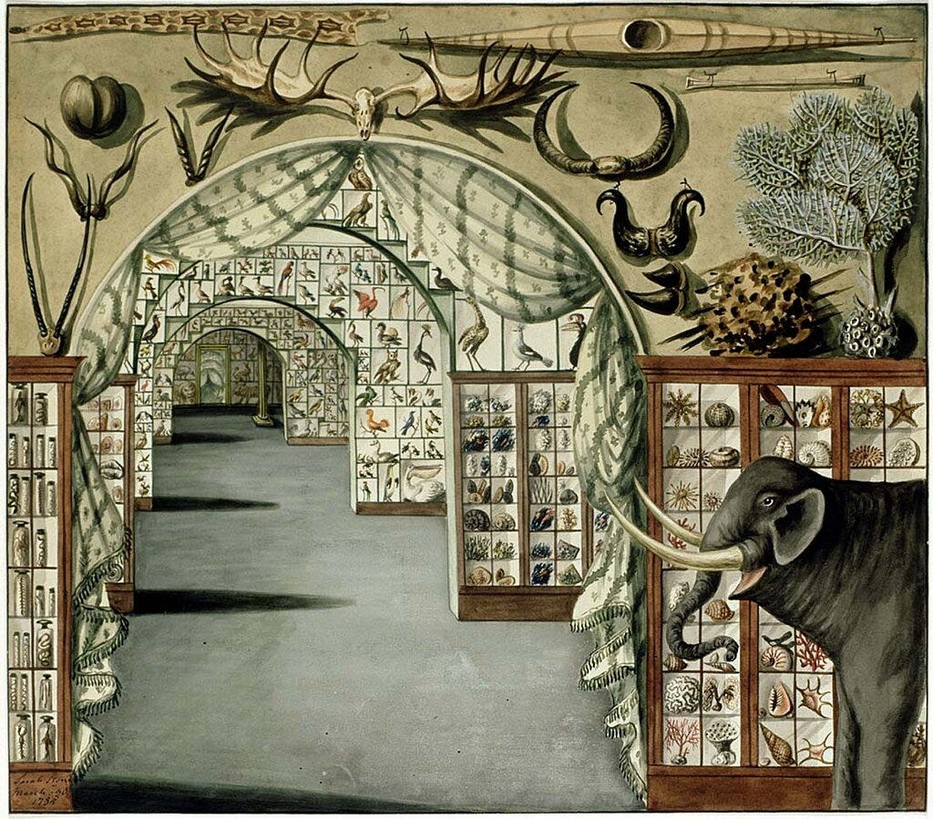
Initially, Lever charged 5s. 3d. for entry, or two guineas for yearly access. The venture enjoyed some financial success, with 1782 receipts totalling £2253. To boost attendance, he later reduced the fee to half a crown. Despite his constant pursuit of new exhibits, Lever's expenditure on acquisitions outpaced entrance revenue. The museum had to close.
Leicester House was demolished in 1792 due to rising debts following the extinction of the Leicester peerage. It was replaced by Leicester Place. That in turn was converted into a church in 1865 and it is now the site of the Prince Charles Cinema.
Leicester Square became the focus of a landmark property law case - Tulk versus Moxhay - in 1848. The plot’s previous owner had agreed with the covenant not to erect buildings. The law back then did not allow purchasers who were not ’privy’ to the initial contract to be bound by subsequent promises. The ruling of the judge, Lord Cottenham, established that future owners could be bound by promises of inaction, preventing the circumvention of initial agreements.
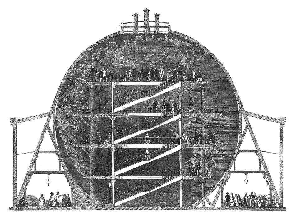
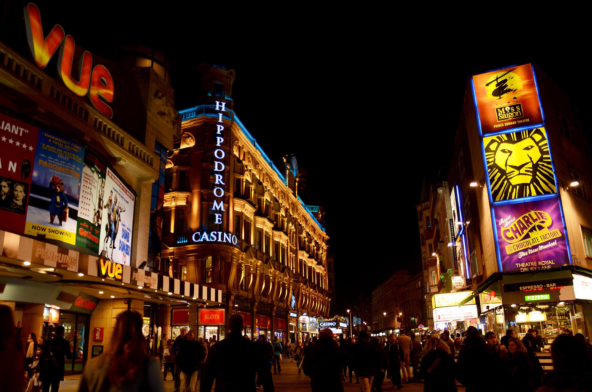
Into the nineteenth century, Leicester Square was noted as an entertainment venue, with many amusements peculiar to the era. Wyld's Great Globe was built for the Great Exhibition of 1851 and housed a giant scale map of Earth.
In 1854, the Alhambra, a large theatre was built and several hotels grew up around the square, making it popular with visitors to London.
Charles Augustus Tulk's descendants, continuing their family’s gripe, erected a wooden fence around Leicester Square in 1873. But to no avail. The following year, a certain Albert Grant acquired the remaining freeholds and gifted the garden to the Metropolitan Board of Works, financing its landscaping himself. Ownership subsequently transferred through various public entities, ultimately coming under the City of Westminster's purview.
The Alhambra burned down in 1882, but reopened the following year. In the early 20th century, it became a popular venue for ballet. It was demolished in 1936 and replaced by the Odeon Cinema.
In 1884, the Alhambra was joined by the Empire Theatre of Varieties. This theatre closed in 1927, to be replaced by the Empire Cinema.
With the decline of the cinemas after the Second World War, Leicester Square developed a seedy reputation. Things were not helped by the 1979 ’Winter of Discontent’ when refuse collectors went on strike. Leicester Square was used as an overflow dump, earning it the nickname of ‘Fester Square’.
Westminster City Council were concerned that the square was becoming too dangerous at night, and wanted to demolish sections of it to encourage the growth of theatres and cinemas, and reduce popularity of nightclubs.
Leicester Square underwent significant renovation in 2010. The project, which included 12,000 square metres of granite paving and a water feature encircling its Shakespeare statue, was completed in May 2012. The 17-month overhaul cost £15.3 million and aimed to create over 1000 new jobs according to the Greater London Authority. The square's revitalisation was unveiled in time for the 2012 Summer Olympics.
It remains a public square, unbuilt upon, simply because a king of England who subsequently lost his head, decided to honour the 1630s grazing rights of locals.
Great insight into one of the most famous landmarks in London
I love your tales, Scott. Thank you so much.