

Kilburn Park
A suburb which sprung up out of nowhere

Today (if you decided to read this on 31 January. If not, where have you been?) is the 110th birthday of Kilburn Park station. Happy birthday, old brown Bakerloo line friend. Kilburn Park station, arriving only in 1915, was a bit of a latecomer to be honest.

There’s a huge swathe of housing completely covering an area west of the Edgware Road (a.k.a. Maida Vale/Kilburn High Road).
As can be seen on the Google Map extract above, a road (Kilburn Lane) enters the map on the left side. South of Queen’s Park station, Kilburn Lane becomes a major west-east running road called Carlton Vale. This ends at its junction with Maida Vale and the other side of the A5 - off this map - a road called Carlton Hill continues a route to St John’s Wood.
Carlton Vale sounds like a majestic, ancient road name defining a valley along its length. And perhaps Carlton Hill then leads uphill to St John’s Wood in contrast to the vale. Don’t ya believe it. It’s all completely made up.
It’s nigh on time for a bit of old mapping.

The above map is one of mine, recreated from a number of sources*
Kilburn
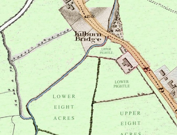
As can be seen in 1800, there’s very little here. Beside the modern Marriot Hotel is a slight, almost indiscernible, dip in Kilburn High Road. This dip marked the former location of Kilburn Bridge which took the Edgware Road/Watling Street over the valley of the River Westbourne. You’d hardly notice it these days, but it was a very important spot marking the parish boundary. Willesden lay beyond the bridge and Paddington before the bridge. There was also a tollbooth here.
Indeed the river continued to mark the parish boundary downstream from the bridge too. It still marks the border between the City of Westminster and the London Borough of Brent, though the river is long culverted and invisible now. Bin days on one side of Kilburn Park Road - running directly above the culverted river - are completely different from neighbours opposite, as a result.
Though we now called this lost river the Westbourne along its length, it was called the Kilbourne one side of the Edgware Road and the Bayswater Rivulet beyond the Edgware Road and south/downstream.
Kilburn Bridge was named after the river it spanned and, once a village developed in medieval times, this was named Kilburn after the bridge.
While in 1800 there is no sign of Carlton Vale, Kilburn Lane was a major through road connecting the Edgware Road with the Harrow Road. It can be seen on the map above taking a bend towards the northeast. Nowadays this old route is only just discernible, taking the line of Canterbury Road and Cathedral Walk. You can still walk it but not drive it, as various post-war housing estates are now in the way.
Kilburn Park
Kilburn Bridge Farm was located just on the Paddington side of the bridge (the building between the Upper and Lower Pightle fields) and its farmland was east of the river.
The farm came into the ownership of the Reverend Edward Stuart in the first part of the nineteenth century.
In 1850, the Rev. Stuart sold a 47-acre plot to five developers, led by James Bailey. Eventually the land purchased was augmented to stretch to the western bank of the river too.
Eyeing a quick profit since the London and North Western Railway (LNWR) had run tracks through the area, the consortium constructed roads and drainage before dividing the land. They contracted smaller firms to build houses in sections.
Early building efforts during the 1850s faltered as buyers were scarce, put off by the isolated position and sodden ground of the River Westbourne's flood plain. And despite the railway, Queen’s Park station wasn’t to open on it until 1879.
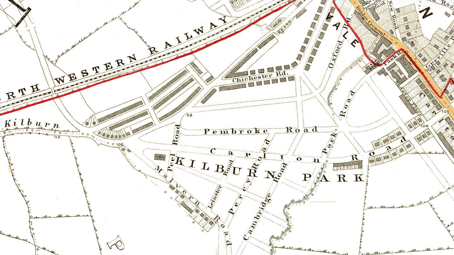
Development stalled until the 1860s. The map above shows the state of play with roads laid out but little housing.
But the new suburb had a grand (invented) new name - Kilburn Park. The name was James Bailey’s idea.
The 1865 map also shows the River Westbourne starting to be sent underground. Once Park Road (later Kilburn Park Road) was extended to run over the top of the watercourse - burying it - some of the flooding issues started to abate, and building started in earnest.
A new architectural trend was emerging using red and mixed-colour bricks. This style was then used across the remaining plots of Kilburn Park.
When is a vale not a vale?
A road called Carlton Road was designed to be the main access to the new estate from the Edgware Road. The name ‘Carlton’ was popular during the Regency period as it evoked elegance through its association with the Prince Regent's ‘Carlton House’. Carlton Road was, like Kilburn Park, a made-up name with no ‘Carlton anything’ in the area hitherto.
Later on, Carlton Road was renamed as the misleading Carlton Vale. It’s misleading as the valley of the Westbourne crosses Carlton Vale rather than running along the length of it. Carlton Vale actually runs down the river valley on one side and up on the other.
The Kilburn Park estate being rapidly completed during the 1870s, it took its cue from the working-class next door Kilburn rather than the posh next door Maida Vale. Many properties were subdivided, some containing as many as six households in the 1880s.
The Anglo-Catholic St Augustine's Church was built nearby on Kilburn Park Road and Paddington Recreation Ground was laid out to the south. Carlton Vale endured significant damage during the Second World War and was substantially rebuilt with modernist architecture, notably the South Kilburn Estate.
Choo choo
As the nineteenth century turned into the twentieth, the LNWR pondered creating a new underground line, mirroring the main line tracks south of Queen’s Park. Although connecting to the Hampstead Tube at Chalk Farm was initially considered for bringing trains from Watford into London's West End, this proved challenging as a construction concept.
The ideas changed. Extending on another route south from Queen’s Park gained momentum and, in 1911, it was mooted to extend the London Electric Railway (LER) company’s Bakerloo Line up to the LNWR station.
The Bakerloo Line scheme, whilst more expensive, was selected instead as it provided direct West End access - if Bakerloo services were extended along the LNWR route to Watford Junction - without passengers needing to change trains.
The LER benefited considerably from this plan, gaining new passengers and utilising spare capacity on existing tracks at minimal expense. The arrangement also resolved the challenging matter of the Bakerloo's approach to Paddington station, where complex surface infrastructure had previously hindered progress beyond Edgware Road. The extension to Paddington opened in 1913, with the Great Western Railway contributing £18,000 to its construction.
The outbreak of the First World War, coupled with severe weather, delayed construction of the northern extension. The Bakerloo service commenced on 31 January 1915, initially serving only Warwick Avenue and Kilburn Park stations. Queen’s Park (Bakerloo line) opened shortly after on 11 February, despite being unfinished, followed by Maida Vale on 6 June 1915.

Stanley Heaps designed Kilburn Park station in a modified version of Leslie Green's terra cotta Bakerloo line style, omitting the characteristic first-floor semi-circular windows. As one of the earliest Underground stations built for escalators instead of lifts, the building required no engine room and was constructed as a single storey.
Maida Vale station - the next station down the line - was the first London station to have all-female staff. When it opened in 1915 during the First World War, there were two ticket collectors, two porters, two booking clerks, and two relief ticket collector-booking clerks. Kilburn Park station was also staffed by women, though not exclusively so.
Because of the shortage of male workers, women’s roles expanded on the Bakerloo Line – first of all in stations like Maida Vale and Kilburn Park, but eventually onto trains too. In August 1918 an unofficial strike, mainly affecting this line, played a part in moving towards equal pay for women.

A heart-warming hostelry tale
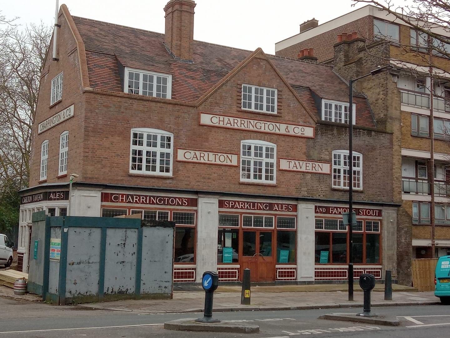
The Carlton Tavern on Carlton Vale was opened in 1921 by the Charrington Brewery. Architect Frank J. Potter designed the building to replace its predecessor, which German bombers destroyed during the ‘Gotha Raids’ of 19/20 May 1918. Notable for its preserved 1920s interior and faience tiled exterior, it was one of the only buildings on Carlton Vale to survive Second World War bombing.
The building was being considered by Historic England for Grade II listing when it was unexpectedly demolished on 8 April 2015 by its owner to make way for a block of flats above a new pub.
Its manager had been instructed to ‘close for an inventory’ on Easter Monday, returning two days later to find the building destroyed.
On 5 May 2015, Westminster City Council issued an unprecedented enforcement notice ordering the developer to "recreate in facsimile the building as it stood immediately prior to its demolition". The notice also prevented the sale of the site until the pub had been rebuilt.
The pub reopened on 12 April 2021 as COVID restrictions lifted.
NOTES:
* Recreation based on the 1800 Milne Landuse map underlaying the 1829 Greenwood map with field names gleaned from a parish map.
I lived off the Kilburn High Road from 1960-68, with my parents. The Marriott Hotel is built, I believe, where the Essoldo Cinema was and to which we'd go every Saturday. There is an old photograph of the Toll Booth right there. I will have to notice the slight dip you mention the next time I am there. I also happened to be there when Kilburn Park Station turned 100, not for the celebrations though. BTW I lived on Alexandra Road, at the junction of Priory Road. The Victorian house was pulled down and the road was changed in name to Langtry Road and the hideous Brutalist Alexandra Road Estate was built. Love your posts.