

Everything's gone east
Job titles flowed downstream: from watermen to stevedores to container checkers

This week I’ve been exercising my middle class sense of entitlement by attending the Hay Literary Festival. It’s been a hot week and those evenings where I was supposed to come back full of cultural ideas and start scribbling, turned to recovering each day with a cold cider and lethargy.
As with the Beatles’ A Day In The Life, where John and Paul both contributed snippets of a song without a home to create a new work, I have dozens of snippets lying around in draft form waiting for somewhere to use and include them.
Today is Snippet Day.
I have used three historic map sets of London and looked at the development of London docks. I was waiting to write about Tilbury and containerisation but that can wait.
Rocque - 1750s
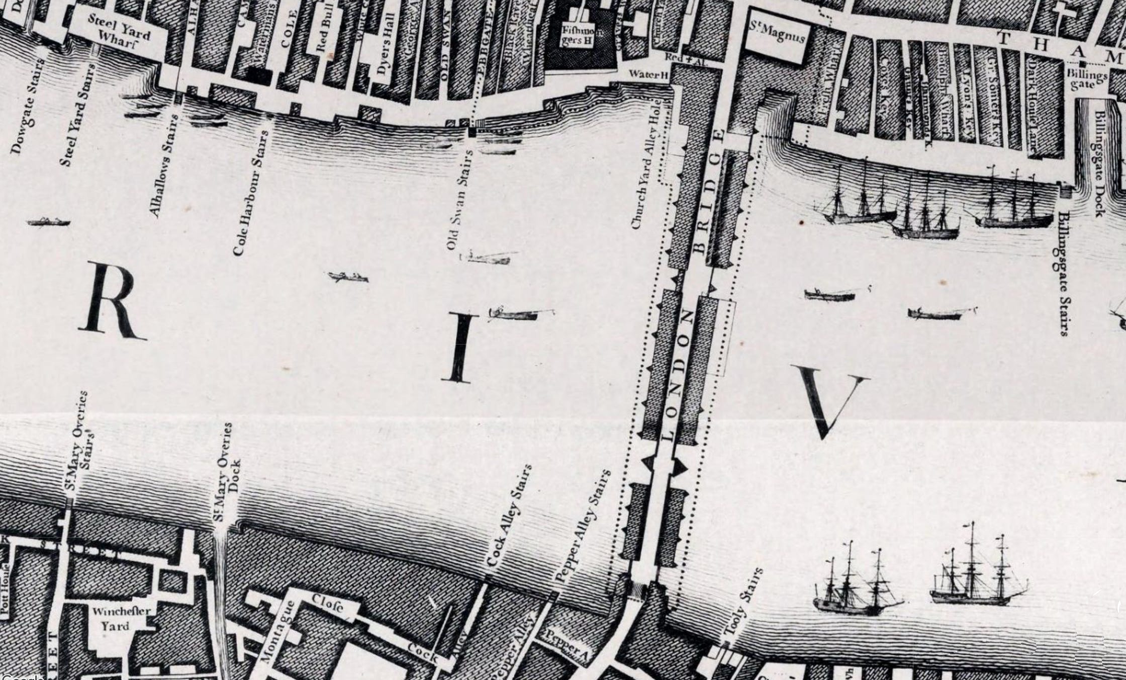
On John Rocque’s map, the Thames in the Pool of London, upstream to Lambeth, downstream to Bermondsey and beyond is a working river in the most literal sense. Trade happens on the water. Ships anchored mid-stream for days, sometimes weeks, waited their turn at the legal quays - a handful of licensed wharves clustered tightly east of London Bridge where customs officers could keep watch. Lighters shuttled cargo ashore. On the map, the riverbank is dense with shipyards and repair yards, but there are no enclosed docks, no controlled basins. The river itself is the port, and it is overwhelmed.
Greenwood - 1820s
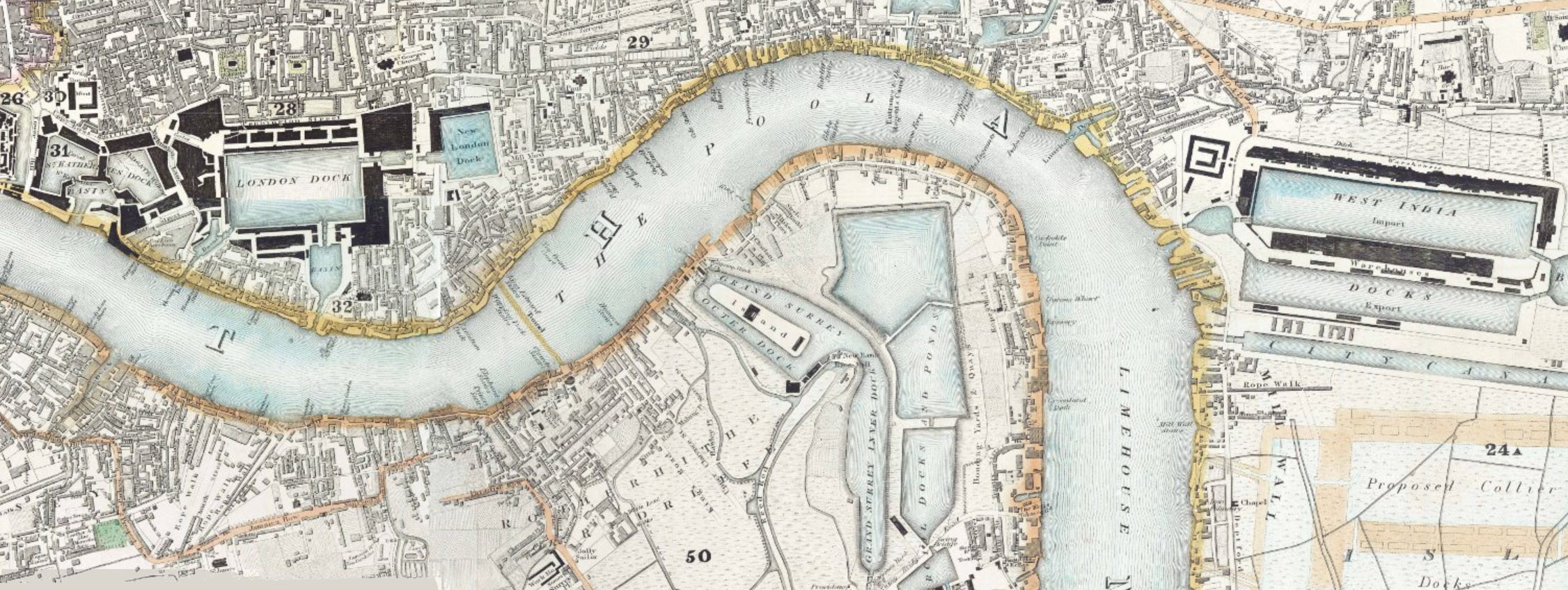
By the time Charles and John Greenwood surveyed London in 1829, something fundamental had changed. The West India Docks had opened on the Isle of Dogs in 1802, followed by the London Docks at Wapping in 1805 and the East India Docks at Blackwall in 1806. On the Greenwood map you can see these new geometries cut into the north bank - rectangular basins, straight-edged and deliberate, quite unlike anything Rocque recorded. St Katharine Docks, blasted out of a dense residential neighbourhood immediately east of the Tower, had just opened the previous year, demolishing over a thousand homes in the process. The principle of the enclosed wet dock - ships floating at a constant water level, loading and unloading in an orderly, secure environment - had been proven. Much of the activity is going east - downriver but the transformation is underway, not complete.
Stanford - 1860s
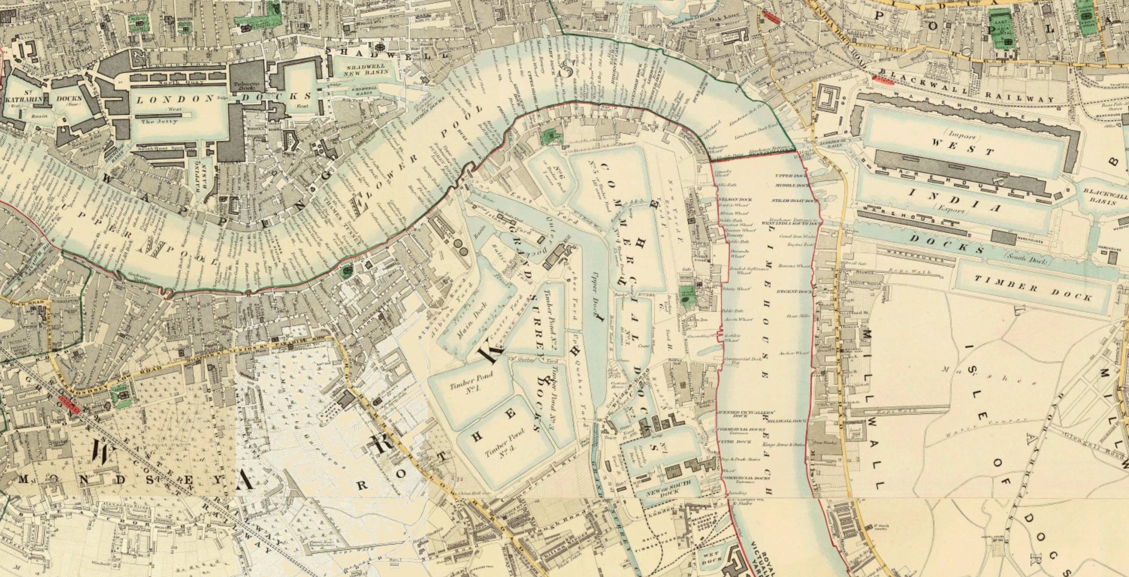
Edward Stanford’s 1862 map shows where that logic was leading. The West India Import and Export Docks dominate the northern end of the Isle of Dogs, Millwall Docks are under construction and the whole peninsula has been surrendered to the enterprise of organised trade. The Surrey Docks have further developed. Further east, the Victoria Dock - the first built to accommodate the new steam-powered iron ships -has opened a new chapter beyond Bow Creek - beyond the limit of the above map. What Rocque mapped as a chaotic, organic river port has become, in little more than a century, one of the most heavily engineered landscapes in the world.
The wharves are still there on the Stanford map, still lining the river. But that way was no longer enough. The wet docks replaced the wharves. In the 1960s, containerisation replaced the wet docks further out into the estuary in Essex. History - never the end; always a continuum.
Notes
Malcolm McLean, from North Carolina, was sitting in a traffic jam at Hoboken, New Jersey in the 1930s. He was watching longshoremen laboriously unloading individual items from a ship and transferring them to trucks, and had the insight that the entire truck trailer body could simply be lifted onto the ship, cutting out all the handling in between. The idea sat with him for years before he acted on it.
In 1956 he converted a tanker, the Ideal X, to carry 58 metal containers on its deck on a voyage from Newark to Houston. That’s generally considered the birth of the modern container shipping industry. He’d sold his trucking company to fund it, which was either visionary or reckless depending on your perspective, and built it into Sea-Land Service, one of the dominant container lines.
The standardisation came later and was a battle in itself - McLean’s original containers weren’t the universal standard. The ISO standard that eventually won out, agreed in the 1960s, gave us the Twenty-foot Equivalent Unit (TEU) as the base measurement. The standard sizes are:
20ft — 6.1m long, 2.44m wide, 2.59m high
40ft — 12.2m long, same width and height
High cube 40ft — same footprint but 2.89m high
Port and ship capacity is still measured in TEUs today. A large modern container ship carries around 20,000+ TEUs.
Containerisation didn’t come from the shipping industry at all - it came from road haulage. The incumbents (the dock companies, the shipping lines, the dockers’ unions) were largely hostile to it, which is why it took so long to be adopted in the UK. Tilbury got its first container terminal in 1967, over a decade after the Ideal X voyage, and the London wet docks were essentially dead within a few years after that.