


Davies's 1852 map of London
A beautiful mid Victorian view of the metropolis

I make many videos about the history of areas around Underground stations, illustrating them with old maps to show the ongoing changes in London suburbs. This week I was making one of Kentish Town. In the process I rediscovered this quite beautiful 1852 map from cartographer B.R. Davies.

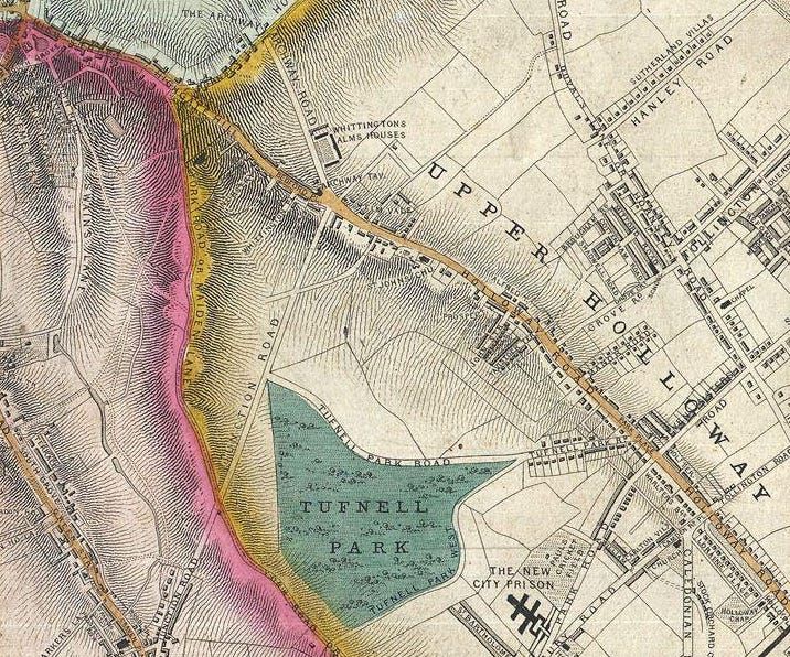
The map extract above is the area around and south of Kentish Town and shows this part of the capital in a state of transition. On this extract alone we can spot a suburb name which no longer exists - Camden New Town - just off-centre to the right. This was the name given to the area around the then-new Camden Square, later home to Amy Winehouse.
Just to the east of that was the proposed Metropolitan Cattle Market, later built as the Caledonian Market, on the open Copenhagen Fields.
On the the top edge of the map is the ‘New City Prison’ - later to be called Holloway Prison and on the bottom edge is Agar Town which was swept away by the tracks into St Pancras a decade after the map.
(N.B. so I don’t have to add the same caption to every extract, all maps in this post are part of the Davies 1852 map as published by Stanfords)

Benjamin Rees Davies (1789-1872) was a prominent London-born engraver, cartographer, painter and map publisher of the early to mid-19th century. After apprenticing under John Lodge in 1803, he began publishing maps as early as 1811, often incorporating his own survey work.
From 1848, Davies started to collaborate with Stanford's map publishing firm. He pioneered the use of steel plate engraving, exploiting the material's hardness to create exceptionally detailed and finely crafted maps. His street plans earned him particular recognition in Britain. His London map identified buildings, parks, roads, bridges and key locations across the capital.

Davies later worked with various cartographers across France, Mexico and America. His maps and plans continued to be updated and published into the 1880s, well after his death. His significant contributions included engravings for the Dispatch Atlas, where his technical skill and precision were notably displayed.
In 1852, Stanford & Company published ‘Davies’s New Map of the British Metropolis, The Boundaries of the Boroughs, County Court Districts, Railways, and Modern Improvements’.
This detailed pocket map shows central London spanning east to west from Chiswick to Bugsby's Reach and Victoria Docks, and north to south from Stamford Hill to Nunhead Cemetery. Davies produced yearly updates until the 1870s, capturing London's growth as railways linked outlying areas to the city centre.
If you want to peruse this map for yourself, you can go to:
www.theundergroundmap.com/osm.html?id=50&zoom=14&annum=1850&show=all
I’ve started it off centred on Bond Street but you can scroll around the map. Paid Substack subscribers can download (and then print) their own extracts focusing on the area you are interested in and clicking Request this map at the top of the page
In the meantime, here is the YouTube video which includes the map:
What a wonderful map. It really highlights the importance of the Surrey Docks & Deptford Royal Docks at that time. So much interesting detail.
Nice! That was a new one on me, thanks! Also, I hadn’t realised Camden New Town is defunct as a place name. I’m sure I’ve used it from time to time - probably explains why people so often give me blank looks.