


Bermondsey - Biscuit Town
Bermondsey - Biscuit Town
Not far east of Tower Bridge, Bermondsey has a long and varied story

Bermondsey is where the Charles Dickens villain Bill Sykes met his grisly end. It's also a tale of monks and abbots. More cheerfully, it was the home of biscuits.
In this article we’re going to take a virtual walk through the heart of Bermondsey - from one Jubilee line station - the eponymous Bermondsey - to the next one west, London Bridge.
I’ll be taking a long and winding road so that we get to cover a lot of ground. And if you haven’t the patience for all this reading. Well. Let’s face it. Reading is just words, words, words if you’re wired right-brained. So there’s a handy video at the bottom of the post, roughly achieving the same result but in pictures. Video-wise you can also enjoy some pie and mash too. I can’t do justice to that in prose.
Along the rivers of London - both the Thames and the Lea - are a series of place names that literally mean ‘island’.
You can see this with the places that end with the letters ea like Chelsea and Battersea or ey like Putney, Hackney, Bermondsey.
I am tempted to divert into a placename-derivation fest. But I won’t. Suffice to say that Bermondsey's name may derive from Anglo-Saxon Beornmund's island.
Bermondsey features in the Domesday Book and was then owned by William the Conqueror. We’ll come back to its older history later but long as that history is, only in the year 1999 was Bermondsey connected to the London Underground when the Jubilee Line opened a tube station.
Our meandering tour will start at the station.
Jamaica Road
We’re exiting Bermondsey station onto Jamaica Road. We’re going to cross from one side of Bermondsey to the other. Should you be doing the walk, turn left outside the station.
Jamaica Road here was named after a house which sold limes, oranges and rum. But you’d never know this from the look of the modern street. It’s a long road running from Southwark Park east to the heart of Bermondsey and now lined with 20th century buildings.
A pleasure garden – Cherry Garden – was founded slightly east of Bermondsey station during the 17th century. Samuel Pepys visited what he called Jamaica House at Cherry Garden in 1664.
This Jacobean building stood in what eventually became called Cherry Garden Street and it was named after the then newly-acquired English colony of Jamaica.
Jamaica Road was named after the house which was demolished during the 1860s, and parts of it were named variously as Bermondsey New Road and Jamaica Row until the whole road was extended under one name later in the eighteenth century.
In 1829, St James’ Church was built near Jamaica Road by James Savage.
By the late Victorian era, Jamaica Road had taken a turn seriously downmarket – housing of appalling condition filled the area and many residents were very poor. Little of the housing remains from that time.
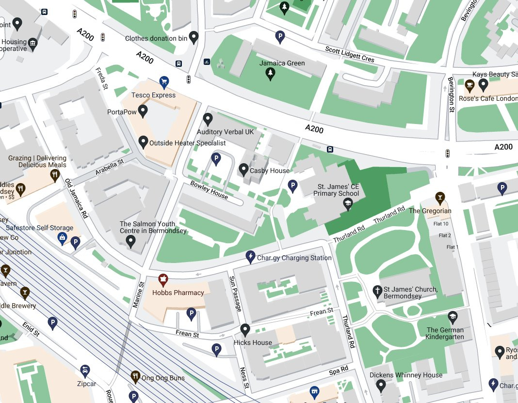
Wartime damage allowed a lot of redevelopment to take place in the 1950s and 1960s, notably the Dickens estate with its high rise buildings. On Jamaica Road’s south side and dating from 1964, Casby House was topped out at 22-storeys.
At a pub called ‘The Gregorian’, this walk diverts along a pathway which widens into a road.
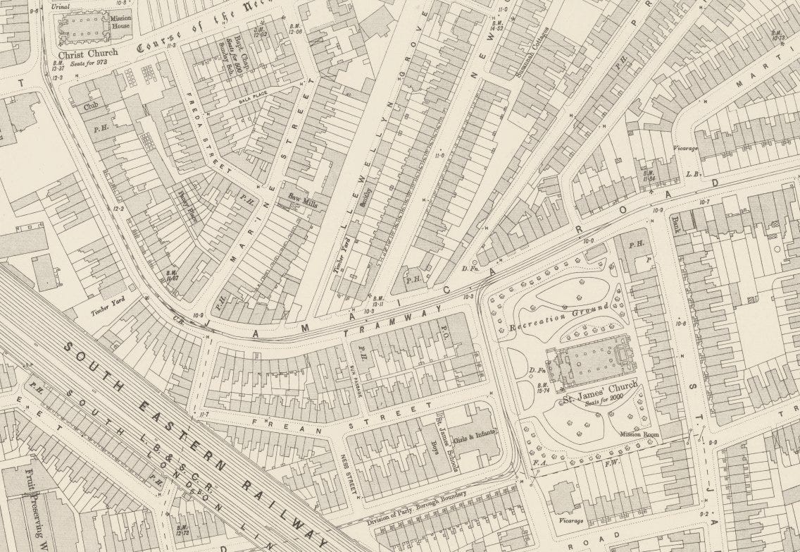
Old Jamaica Road
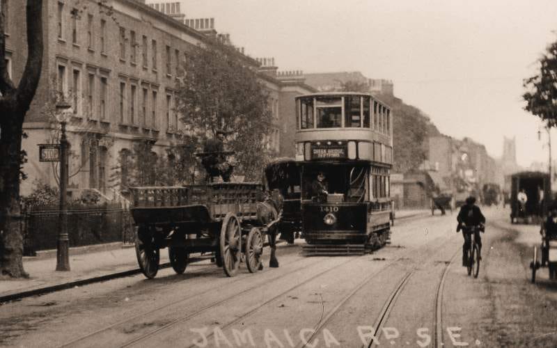
In the 1960s a large section of Jamaica Road was completely realigned and at the same time, widened into a dual-carriageway. Most of the former course became Old Jamaica Road.
It’s hard to imagine, with all the new builds, that it was previously a main road with trams running along it.
Abbey Street
Turning right at the end of Old Jamaica Road, takes us briefly into Abbey Street but then brings us back to ‘new’ Jamaica Road. The other end of Abbey Street, which we don’t walk along here, leads to the abbey. Some fiendish road naming.
Jamaica Road (previously Dockhead)
As we rejoin Jamaica Road, we’ve now entered the SE1 postcode (SE16 before now).
The western section of the modern, rerouted, widened Jamaica Road was previously called Dockhead – called that as it lay at the head of St Saviour’s Dock. Dockhead was the first location of Peak Freen’s biscuit factory.
At the modern Co-Op there’s a view of St Saviour’s Dock.
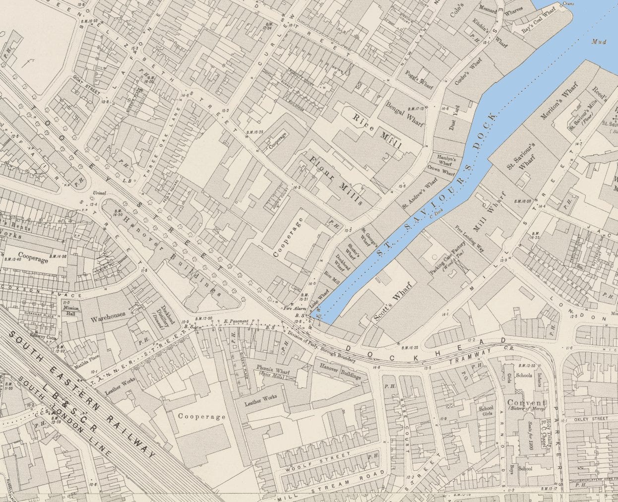
St Saviour’s Dock
Bermondsey Abbey was founded as a Cluniac priory in 1081 dedicated to Saint Saviour.
The monks turned a nearby tidal inlet at the mouth of the River Neckinger into a dock named St Saviour’s Dock, after their abbey.
The Knights Templar also owned land here and the knights gave a name to one of the most distinctive street names in London - Saint John At Thames. Don’t recognise the name? That’s because locals were too lazy to say the whole streetname and in time it became Shad Thames, equally distinctive.
Other ecclesiastical properties stood nearby, one at Tooley Street. The name Tooley Street is also a corruption - it was ‘Saint Olaf's Street’ but again early Londoners slurred their words and it became Tooley Street.
To the east of St Saviour’s Dock was Jacob’s Island. This was claimed as the roughest area of London - although many areas of London claim they were the roughest. The unique mixture of hovels amidst fouled-up drainage ditches in Jacob’s Island caused Dickens to put paid to Bill Sykes there. In the film Oliver!, Oliver Reed performed a fine Bill Sykes death scene in (the Shepperton Studios backlot version of) St Saviour’s Dock/Jacob’s Island.
To the west of St Saviour’s Dock – between the dock and London Bridge was the old village of Horselydown. This was named ‘Horssey Down’ on the ‘Woodcut’ map of London of c. 1561. It was originally a large field for grazing horses and cattle, probably hence the name.
Horselydown lost its identity and became part of Bermondsey as the area industrialised in the 19th century. However the 1872 Ordnance Survey map still called it “St John Horselydown”, meaning the parish of St John’s Church in Horselydown.
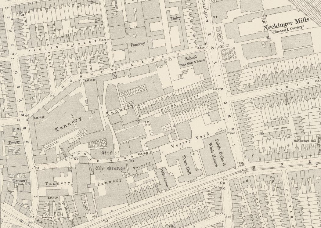
Tanner Street
Crossing the road from the dock on our virtual walk and heading right, there’s then a fork in the road. Take the left fork beside a chip shop, and we’re in Tanner Street, named after the noxious local tanneries of Bermondsey – all now gone.
Tanner Street, formerly Russell Street, played a crucial role in establishing Bermondsey’s reputation as London’s ‘Leather District’. As time progressed, other industries replaced the tanneries and the area began to change. Present-day Tanner Street maintains its historic character through preserved industrial architecture.
As we cross under the Druid Street Arch, we might pause to remember 25 October 1940 when a bomb fell through the railway arch, killing 77 people sheltering from an air raid.
On a happier note, this is part of the oldest railway viaduct in London.
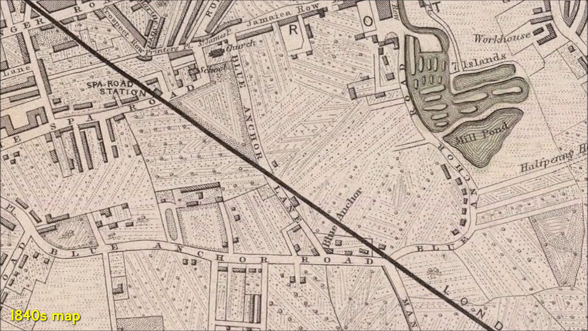
The discovery of a spring upstream on the River Neckinger led to Bermondsey all-too-briefly becoming an eighteenth century leisure resort. The spa was fashionable for a couple of years and give a name to Spa Road.
The London and Greenwich Railway opened in 1836. It was London’s first railway and the local station in Bermondsey was on Spa Road. At the time of opening Spa Road station was right on the edge of London with market gardens beyond. The viaduct continued to Deptford.
Construction of the viaduct had started at Corbett's Lane when this was still in the open countryside (see note below).
Riley Road
Should you be virtually walking under the railway bridge and decide to turn second left into Riley Road, be minded that it is named for Jeremiah Riley, whose family owned a house and land near St Mary Magdalen Church.
Dating originally from the 1850s, Riley Road was called Riley Street until 1936 and was damaged during Second World War bombing. The east side was redeveloped as part of the St Saviour’s Estate in 1960.
Purbrook Street
Purbrook Street now runs between Riley Road (take the second right) and Tower Bridge Road.
At first, before Riley Road and Purbrook Street were a random thought in the minds of Victorian developers, Mellicks Place was a small 1820s cul-de-sac running south from Sun Street (now Pope Street).
There were tanners’ yards behind Mellicks Place and, during the 1850s, Purbrook Street was laid out over the yards. At first it run on to the churchyard of St Mary Magdalene, but in 1902 Tower Bridge Road cut off the western end of the street.
Before the Second World War, the north side of Purbrook Street was redeveloped as the Purbrook Estate. During the war, the south side was completely destroyed by bombing and then redeveloped afterwards.
Opposite the end of the street, but now across busy Tower Bridge Road, is the churchyard of St Mary Magdalene.
Tower Bridge Road
By the 19th century parts of Bermondsey - especially along the riverside - had become a notorious slum with the arrival of industrial plants docks and particularly bad housing.
Industries that were deemed too horrible to be carried on in central London were relocated here.
One that came to dominate central Bermondsey away from the riverfront was the processing and trading of leather and hides.
It was all rather smelly.
In a separate narrative, London planned a new bridge whose southern end emerged in Bermondsey - Tower Bridge, which opened during the 1890s.
The southern end of Tower Bridge emerged onto a road named Horselydown Lane and after that difficult-to-navigate back streets. By 1902, London County Council decided that they needed a brand new road.
Tower Bridge Road only dates from 1902 and was cut through an area of substandard housing. It was an Edwardian-era version of ‘slum improvement’ – i.e. the residents previously there were displaced and needed to find new accommodation on their own. Tower Bridge Road was the penultimate scheme of this sort. Aldwych/Kingsway came along in 1904/5 and society demanded from then on, that local authorities had duty to rehouse displaced people.
Tower Bridge Road - at least in Bermondsey - became a great success. (Not deemed so successful if you’d be made homeless because of it).
If we turn left at the end of Purbrook Street we’ll find that it’s a long road which has effectively become Bermondsey’s High Street. Amongst its many retail establishments is Manze’s Pie, Mash and Eel shop (at number 87).
Before we get to Manze’s, while walking down Tower Bridge Road, we pass Bermondsey Square.
Bermondsey Square
Bermondsey Abbey was situated in the area now known as Bermondsey Square. While the abbey itself is no longer standing, some of its remains can still be seen today. The south-western tower of the Abbey church has been preserved, and it can be viewed below the glass floor of a restaurant and bar, which now stands on Bermondsey Square.
Biscuits
The Peek Frean company was established in 1857 at Dockhead (see earlier).
They moved to a larger plant in Clements Road in 1866 leading to Bermondsey earning a nickname: Biscuit Town. Commuters into London Bridge station, with a train window open, would notice only the sweet biscuity smell of Bermondsey (and not the foul-smelling tanneries)
Wee Willy Harris - usually credited as the first British rock and roller - came from Bermondsey. Before he became famous, he, like many Bermondsonians, also worked at Peek Frean.
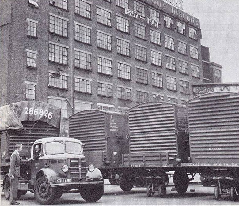
Photo: The delivery yard at the Bermondsey bakery showing trailers and British Railways’ vans and tractor units taking the famous biscuits off to be distributed by train. The building proudly proclaims the years in existence - 1857 to 1961 at that point.
Bermondsey Street
If you didn’t stop for pie and mash, we walk north again – along Bermondsey Street. At the southern end stood the Abbey of St Saviour’s, founded in 1081. We passed Bermondsey Square earlier which was on the other side of it.
Bermondsey Street itself is a delightful thoroughfare, adorned with a variety of trendy cafes, restaurants, shops, and offices. It’s a long old slog up to Tyers Gate where in this particular walk, we’ll be making a turn.
We pass the historic St Mary Magdalen’s Church on the right, which has been a cornerstone of the area since at least 1293. The present church building dates back to 1690, and subsequent modifications were carried out until 1883, marking the final alterations.
Earlier, at the end of Purbrook Street, we had a look at the churchyard behind.
Tyers Gate
Turning left, after quite a long walk, Tyers Gate takes us into Leathermarket Gardens.
Established during the 1930s, this is a charming green space surrounded by flats from the same era. The garden gets its name from the leather market and tanneries that once occupied this area. On the north side of the gardens, there’s an early 19th-century leather warehouse, which stands as a reminder of the area’s past as a hub for leather-related businesses.
Turning at the Bermondsey Village Hall – a community space – we reach Kirby Grove
Kirby Grove
We pass a classic school – Snowsfields Primary School. It’s the sort of school building style featured in black and white in mid-twentieth century TV dramas. Later on, Kirby Grove features some amazing Guinness Trust Buildings on the left.
Melior Place
Crossing Snowsfields from Kirby Grove we enter a very short street – Melior Place. Straight ahead is the Horseshoe Inn.
Melior Street
Melior Street is immediate left at the pub. We are amongst a lot of new builds.
We didn’t take in riverside Bermondsey on this virtual walk. But to the east of Tower Bridge, Bermondsey's three and a half miles of riverside were lined with warehouses and wharfs. The best known was Butler's Wharf.
They suffered severe damage during Second World War bombing and became redundant anyway in the 1960s, following the collapse of the river trade. The advent of containerisation moved this trade downriver to Tilbury.
Many of the wharfs were redeveloped by the London Docklands Development Corporation starting in the 1980s. They continue to be converted into residential flats. Butler's Wharf is the most notable, being vast (see note below).
These apartments are some of the most upmarket and expensive properties in London. Endearingly during the ongoing housing crisis many are empty, as property investments.
Anyway, admire the Melior Street new builds and find more first right in Fenning Street.
Fenning Street
Walk up to top of the street and turn left into St Thomas Street and we’re soon at London Bridge station.
London Bridge station
This needs an article on its own and indeed, there are plans to do such a thing. For the while, for Bermondsey, we’ll leave it at that.
NOTES
One hundred thousand bricks were laid every day to construct the London and Greenwich Railway viaduct, causing a shortage of bricks in the rest of London
In 1997 US President Bill Clinton and UK Prime Minister Tony Blair visited Bermondsey and dined at Butler's Wharf
Find a video of exactly the same thing as this whole article, below
Nice writeup. I’d recommend a tour of the Biscuit Museum on the factory site. The curators (who also worked for the factory) are a real hoot.