


Adventures in historic artificial intelligence
The simultaneous frightening/thrilling ability of using AI in analysis of the past

Before I begin, a single piece of terminology which either you’ll know what it means, or you won’t:
GEOLOCATING (v). Ascertaining the latitude and longitude of a location and placing the found location in its correct position on a map.
This Substack post is relating to the history of London but isn’t the usual type of article. If you’re not into old maps or technology or AI or trial and error, this post is perhaps one you might skip and wait for next week.
That said, off we go…
In 1746, the French-born British surveyor and cartographer John Rocque produced two maps of London and surrounding areas.
The more renowned of these bears the complete title A Plan of the Cities of London and Westminster, and Borough of Southwark: a Georgian London map with a scale of 26 inches to a mile (1:2437), surveyed by John Rocque, engraved by John Pine and published in 1746. Comprising 24 sheets and measuring 3.84 m × 2.01 m (12 ft 7 in × 6 ft 7 in), this cartographic achievement required nearly a decade to survey, engrave and publish, earning recognition as "a magnificent example of cartography" and "one of the greatest and most handsome plans of any city".
It is quite a wonderful and celebrated map. It is gloriously detailed and covers the whole area between Marble Arch and Limehouse (west to east) and between Euston and Deptford (north to south).
It has existed on my website (www.theundergroundmap.com) for 15 years now but it is so detailed and densely packed that I have simply featured it as a work of cartographical beauty.
The About section of The Underground Map does ambitiously state that it “is creating street histories for the areas of London and surrounding counties lying within the M25. The aim of the project is to find the location every street in London, whether past or present, and tell its story. This project aims to be a service to historians, genealogists and those with an interest in urban design. The website features a series of maps from the 1750s until the 1950s.”
Thanks to OpenStreetMap I have geolocated (nearly) every modern street. Thanks to British History Online and other similar sources, I have delved into the history of many streets, old and new. Thanks to the magnificent beast below (bought in an Oxfam shop of all places), I have discovered how street names change over the years.
Often my time doesn’t use all of those great resources - instead it is spent simply staring at old London maps to see where former streets were, discover where their modern location is and add them to the database.
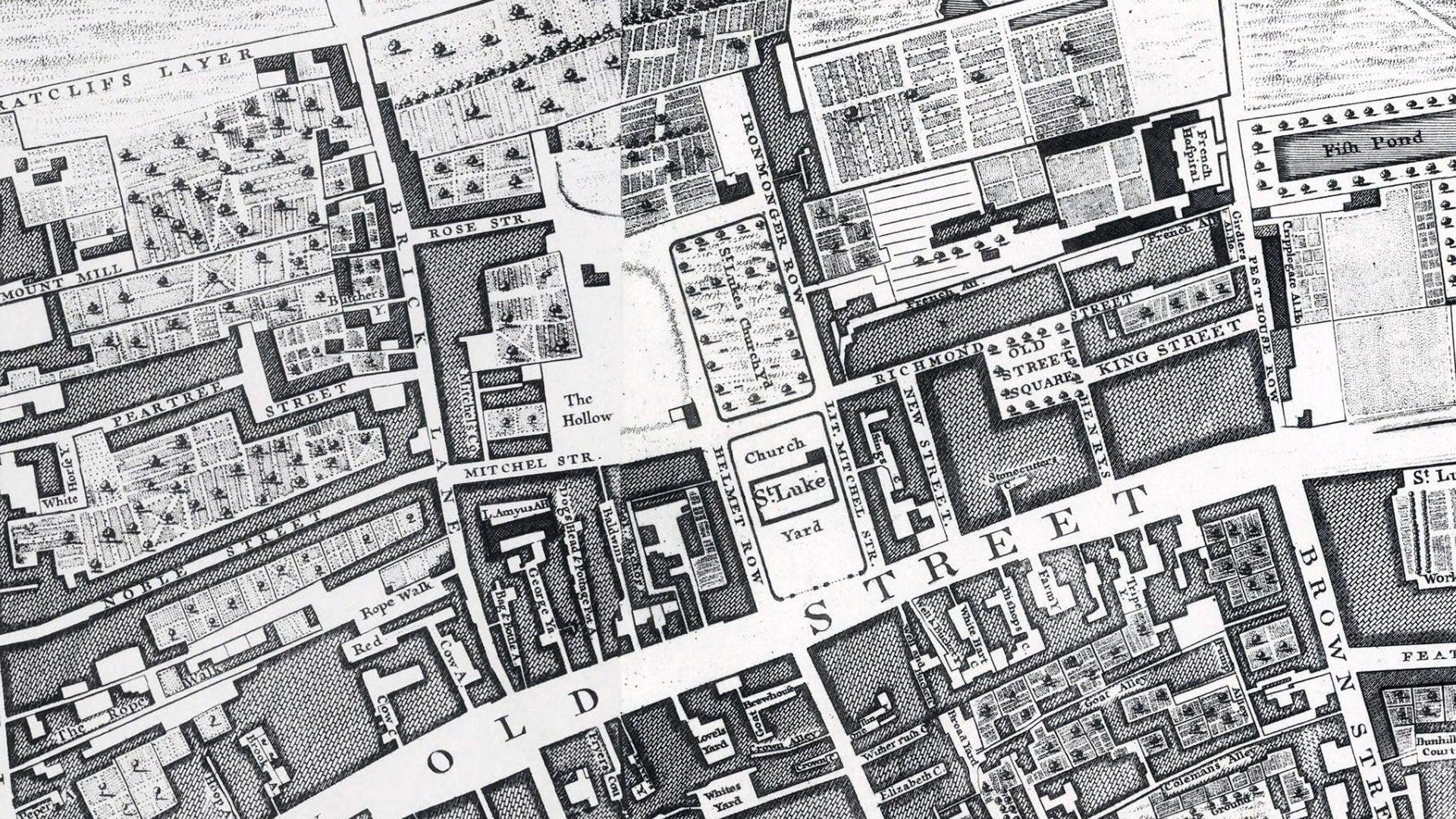
Below is a zoomed in section of the first John Rocque map above, just south of Old Street - just look at all those tiny yards he’s surveyed. If I were to geolocate all those courtyards throughout 1746 London, it’s going to take years of my time.

So despite my website claim - the aim of the project is to find the location every street in London, whether past or present - roads I’ve added to the website which appear on the 1746 map happen by means of other research and not ‘map-staring’.
This has been my position for 15 years. I’d slowly geolocate streets which Rocque coincidentally surveyed without processing the map itself. Many 1746 streets would appear in geolocated locations on www.theundergroundmap.com but not because I found them on the Rocque map.
All very well but it meant things won’t be added as quickly to the project than I’d want.
2022 happened. Along came ChatGPT and then its AI followers. I began pondering…
Could AI look at an old map and create a list of all the streets it saw? The answer until very recently was “no”. I tried ChatGPT, Claude.ai and others. I gave them a section of the John Rocque map and they were hopeless at finding and listing all of the streets, alleyways, churches, wharves…
On the top Rocque map extract, ChatGPT told me that Old Street and Brick Lane featured on the map. “Can you see any further streets?” I typed. “Yes, Brown Stre” it replied. Three streets and one of the names curtailed.
Claude.ai was slightly better and found a dozen streets or so. But no alleyways or courtyards - apparently beyond its capability. I have tried other AI programs as they have appeared on the scene but no earth-shaking progress.
I kicked the idea into the long grass. This would require some AI progress to occur.
Along, a couple of weeks ago came Gemini from Google. It’s free to use at the moment. You can write essays, create music and images with it. The usual AI stuff. But I uploaded the Old Street 1746 map section to it and supplied the usual prompt I’ve tried with its competitors:
I will supply an old map of London.
Find all streets, roads, alleyways on the old map and look for streets on the modern map which have exactly the same name. Find the lat/long for the new street and apply it to the old street.
Find all streets on the old map where they don't match a modern street. You'll have a decent scatter of correct lat/long pairs from step 2. Extrapolate the approximate lat/long of the remaining old streets
Expand the old St/Str and equivalent abbreviations to the full name
Create a CSV spreadsheet and list in alphabetical order by old street name and these columns:
Old street name
Modern street name (if known)
Decimal latitude
Decimal longitude
Any notes you have found in trying to locate the old street
The result was stunning:
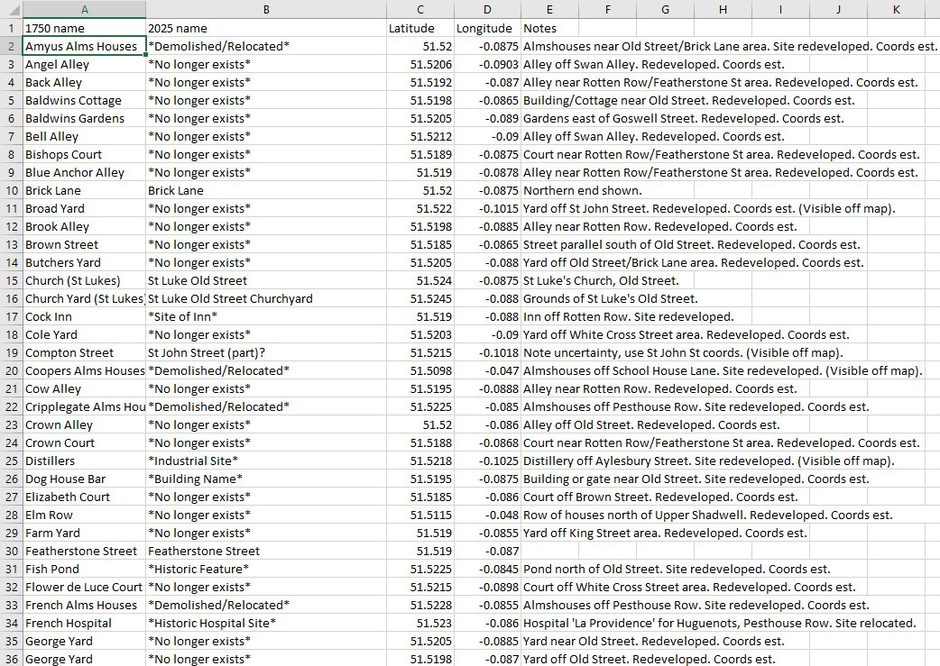
Not only did it give a list of nearly every readable piece of text on the map but an approximation (sometimes a terrible approximation) of its latitude and longitude. Also it has deep-dived into London street history to give context in the the Notes column. I know AI is supposed to save/destroy the world but this I find amazing.
Adding the findings into my website, we get this:
www.theundergroundmap.com/article.html?id=1750
Click the link and you’ll see the John Rocque map, Google Gemini’s markers and some of my earlier ones.
REMARKS:
Most of the 5440 new markers on the website map at the link above are Google Gemini’s processing of the John Rocque maps. Gemini told me that my entire Rocque map was too big to process and so I spent a lot of time splitting the whole map into sections, processing those into spreadsheets - one per map section.
Once done, I used Powershell on the PC to consolidate each spreadsheet into one master spreadsheet. I then had the laborious task of removing as many duplicate entries as I could since the map sections overlapped.
Google’s work hasn’t been always successful:

Few of the markers above are in the correct location and so I’ll need to correct the geolocations of these. While they refer to most objects and streets on the map - one per location - these are nearly all in the wrong place.
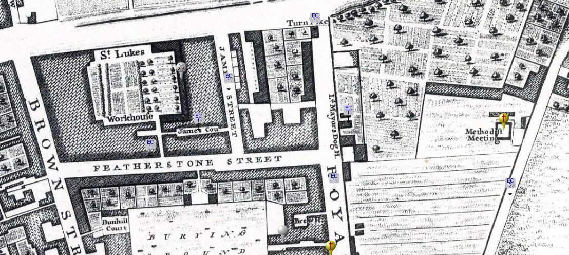
Slightly north is better. Street markers are in the correct place. Google Gemini successfully pinpointed the Lord Mayors Dog House - what a wonderful place that sounds!

Success on the original sample area around Old Street is patchy. Old Street and Helmet Row have markers as does St Luke’s. All of those courtyards were found and listed but their locations have been scattered over Clerkenwell - which I now have to fix!
In summary: Some AI programs can now find everything on a old map you supply but it’s still not so good at geolocating perfectly, but I can live with that (and slowly correct these)
I hope you didn’t mind this slightly off topic tome this time.
NOTES
For reasons of clarity on my website, I call this Rocque map the 1750s map, not the 1746 map.
I have to mention Matt Brown’s excellent work colouring in the Rocque map over on the Londonist site which is a grand thing to behold:

A really interesting piece Scott - many thanks and keep going. We need you to succeed!
Love this! Great work. Maps are great. Your dedication is great.
Thank you! 👍