


A short history of Trafalgar Square
'The very centre of London', it says here

Charing Cross is widely known as the very centre of London. Today the point from which all London road distances are measured is marked by an equestrian statue of Charles II.
Charing was originally a rural village on the northern fringes of Westminster.
A cross had been placed here in the 13th century and frequently the area was becoming known as Charing Cross instead of (simply) Charing.
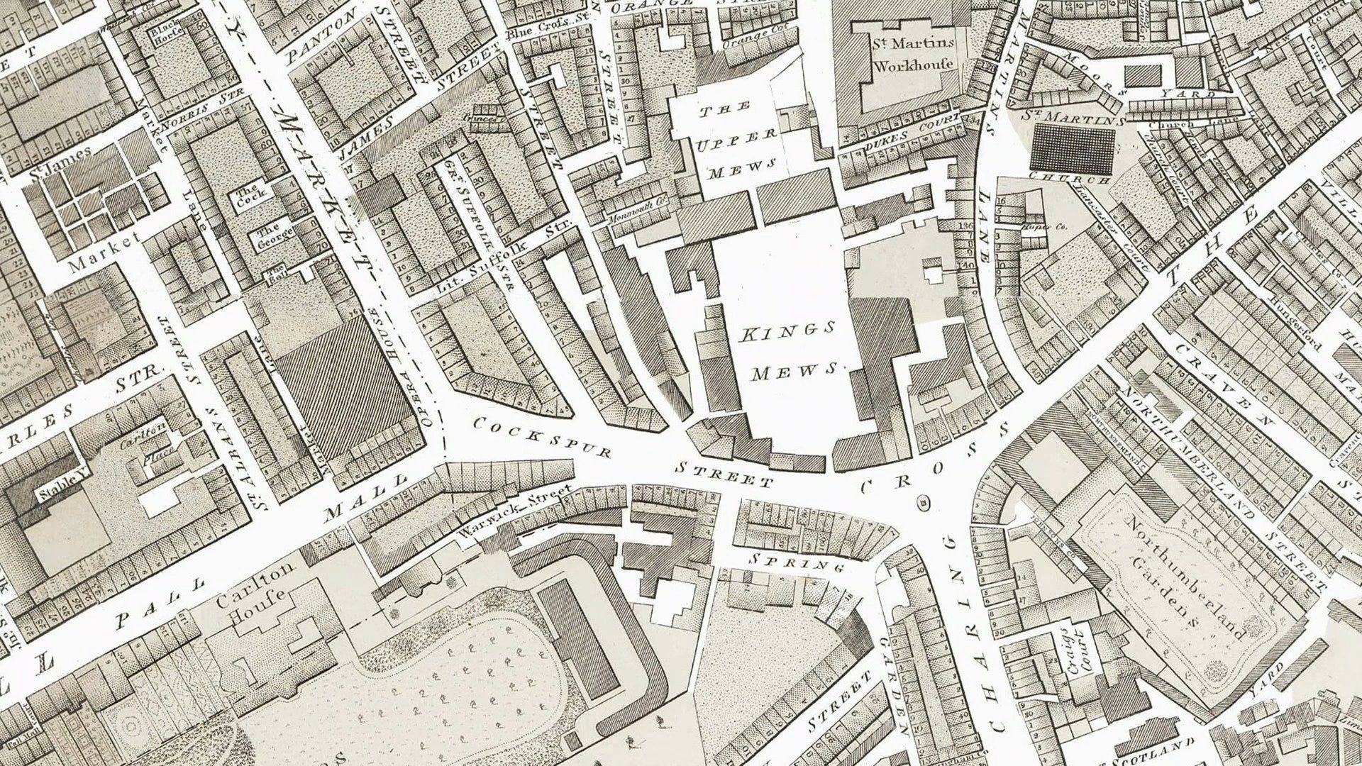
Let’s introduce a map. We’ll start looking at the area south of the Charing junction and travel anti-clockwise around it.
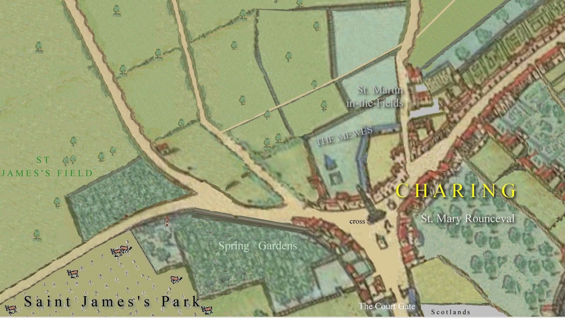
On this reconstructed map (by yours truly*) you can see Whitehall running due south through The Court Gate.
To the east of Whitehall is an area called Scotlands - later called Old Scotland Yard
In the year 1290 Queen Eleanor of Castille - who was the wife of Edward I - died quite unexpectedly near the city of Lincoln. Edward was heartbroken and he ordered that her body should be brought in solemn procession back to London and be buried in Westminster Abbey.
A procession of all the Lords and Ladies of the day had to walk behind the coffin as it made its way to London - a distance of over 200 miles. It was the longest formal procession that England has ever witnessed.
Every evening the coffin was laid in a building en route. It arrived in London at Cheapside. The next day the procession was quite short, being only from Cheapside to the western end of the Strand, where it was laid overnight in the Church of the Priory Hospital of St Mary Rounceval before the final, short distance to Westminster Abbey.
The priory was a 'hospital', founded in 1231 by William Marshall, Earl of Pembroke to serve travellers on their way to the shrine of Edward the Confessor in Westminster Abbey. In those days the word 'hospital' simply meant ‘a place where strangers could stay’. The word used in this sense became our modern word 'hostel' or 'hotel'.
There's no longer any trace of the priory/hospital. Today it would be on the site of the entrance to Northumberland Avenue. It fell victim to the Dissolution of the Monasteries, which continued into the reign of Edward VI when this one disappeared.
Much earlier, previous king Edward I ordered that every place where Eleanor's body had rested be marked with a commemorative memorial cross. So the village of Charing got its own cross, outside the priory.
The Strand (these days simply Strand) stretched east from here and ribbon development could be seen taking place along its length. It would still be a while before large houses built down to the Thames from The Strand disappeared.
Just to the north of the village of Charing was the church of St Martin-in-the-Fields. There's been a church on this site since at least the medieval period. It was located in the farmland and fields beyond the London city wall. It was awarded to Westminster Abbey and became a principal parish church. Its present building was constructed in a neo-classical design by James Gibbs in 1726.
Directly north of the cross at Charing was a royal mews. The royal falcons and hawks were kept at this site from 1377 onwards and the name originates from the fact that they were confined there at molting time. Mews is derived from the French verb muer - to molt.
The mews building was destroyed by fire in 1534 and was rebuilt as a stables. It kept its former name even though it had acquired a new function. It thus gave the word mews, as in stables, to the language.
Running northwest from Charing Cross was the Haymarket.
Haymarket was originally a street market for the sale of fodder and other farm produce. At that time it was a rural spot with the village of Charing being the closest settlement.
In 1692 the street was paved, and a tax was levied on the market traders: 3d for a load of hay and 2d for one of straw. In 1830 the market was moved by Act of Parliament to Cumberland Market near to Regent's Park, leaving the street name as a reminder of a previous life.
To the west of Haymarket was St James's Field.
King Henry VIII enclosed this large field sometime between 1536 and 1547. By 1576 St James's Field was bounded by a ditch to the north at modern Piccadilly.
The south of the field was bounded by an old highway which led from Charing Cross to St James's Hospital which stood on the site now occupied by St James's Palace. It was founded probably in the 11th century as a colony for 14 leprous maidens.
Since the game ‘palle malle’ (a ball game similar to croquet) was played there, the southernmost section of St James's field was later renamed ‘Palle Malle Field’. The road next to it became called Pall Mall in 1661. Palle-Malle had been introduced to England by King James I.
Further anticlockwise on the map, Spring Gardens were indeed gardens. They featured a decorative fountain in the time of Elizabeth I that was set in motion by passers by treading on hidden machinery, either knowingly or unknowingly. It must have been so highly amusing.
We've now completed a circuit of Charing Cross and it's time to travel forward in time.
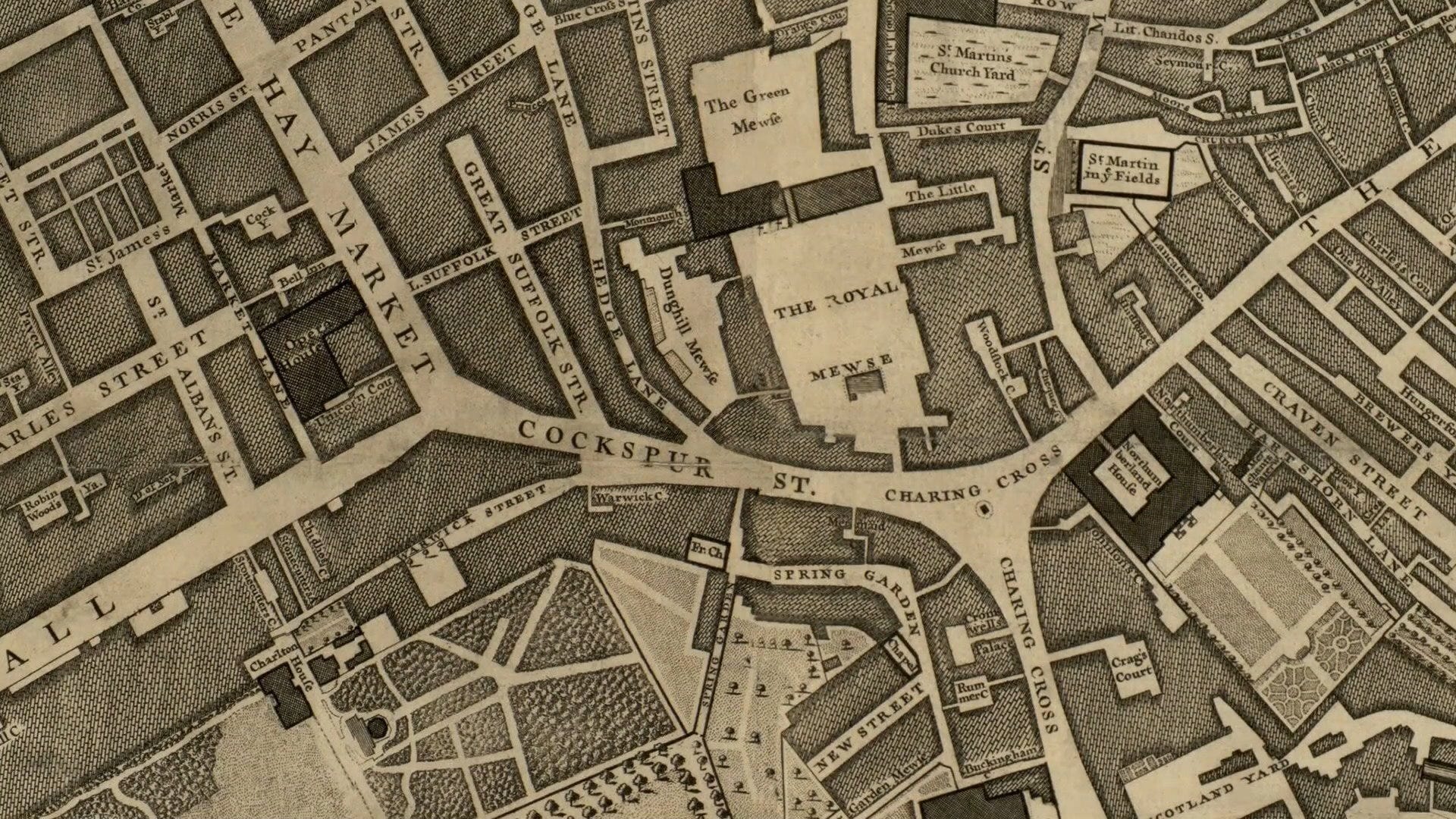
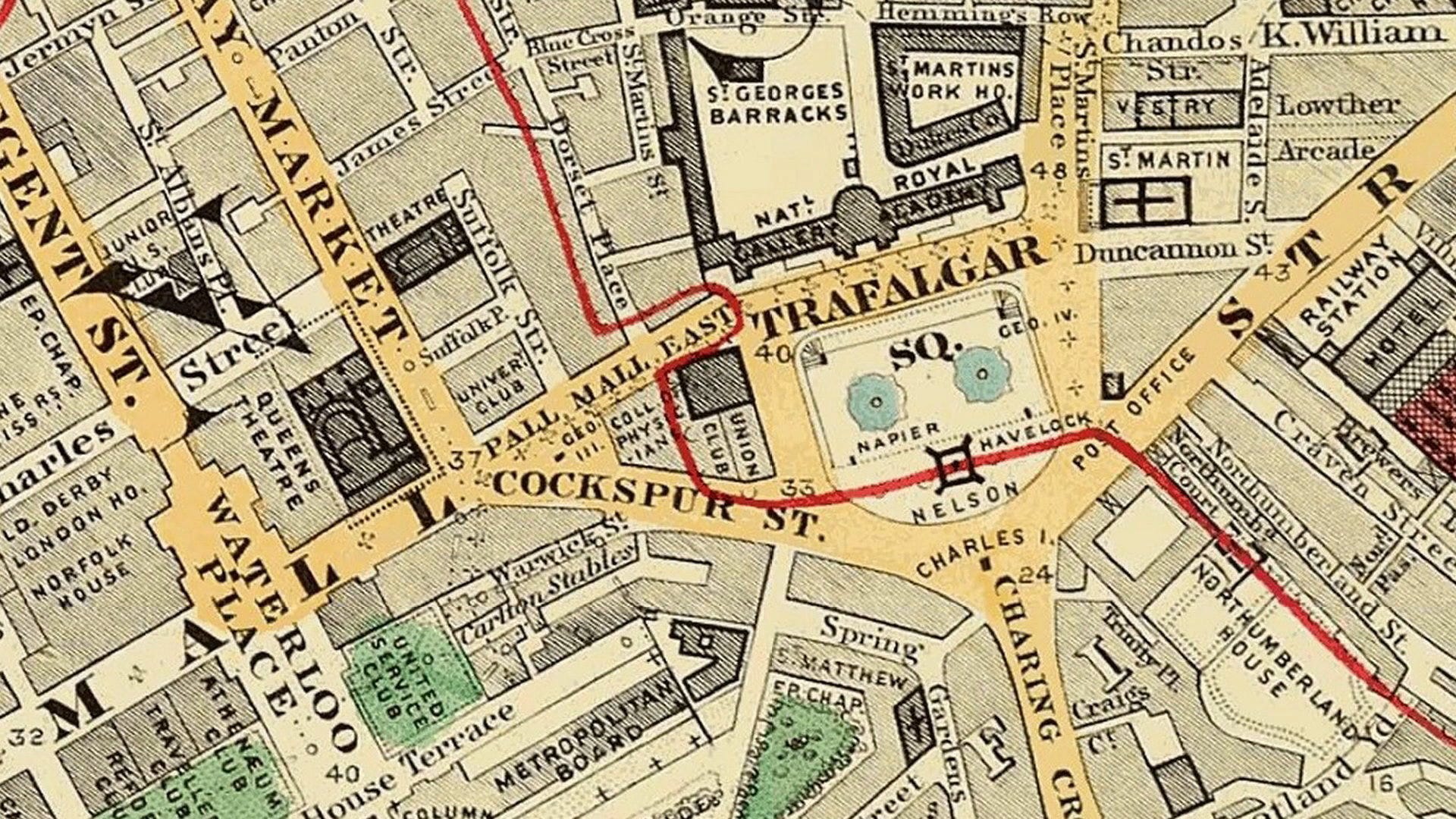
John Rocque created a major map of central London in 1746. This is a cross-section of that map. The main thing to note is how urban the area has become. There’s a point on the map marking where Charing Eleanor Cross had been. The memorial had been destroyed in 1647 on the orders of Oliver Cromwell during the English Civil War since it was too ‘royal’.
Cromwell's star faded. Well actually he more died than faded. The site of the cross needed a ‘something’ and so it was occupied by a statue of King Charles I mounted on a horse.
I remember being told that there was an equestrian statue code that sculptors followed.
If all four hooves were on the ground, the rider had died of natural causes
One hoof raised meant 'died as a result of injuries in battle'
Two hooves raised who's raised means that the rider died directly in battle
One hoof is raised here with Charles I. I guess being executed on a cold February day is sort of ‘in battle’. But what a load of rubbish this myth is.
Anyway, the site of the statue, formerly the site of the Eleanor Cross, is recognised by modern convention as being the very centre of London.
On the previous site of the Priory Hospital of St Mary Rounceval, Northumberland House had appeared. This was the London residence of the Percy family who were Dukes of Northumberland. It stood at the far western end of Strand from around 1605 until it was demolished in 1874. In its later years it overlooked Trafalgar Square.
In the general urbanisation of the area, St Martin's-in-the-Fields is now tucked away up St Martin's Lane completely surrounded by other buildings.
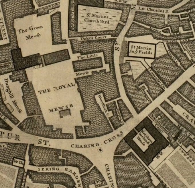
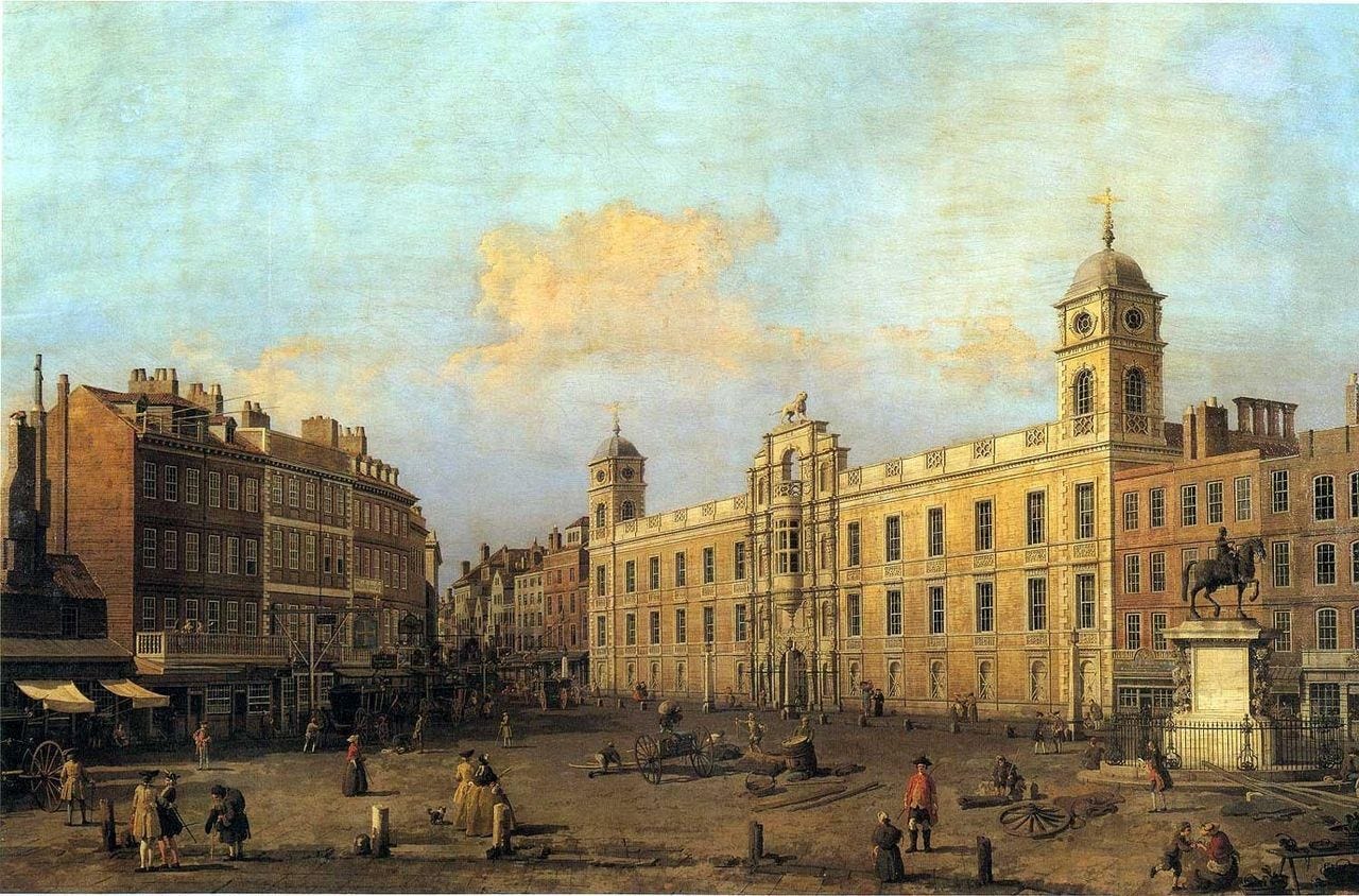
The Royal Mews was rebuilt in 1732 to the designs of William Kent and in the early 19th century it was open to the public. Kent's redesign was an impressive classical building occupying the northern half of the site. There was an open space in front of it that ranked amongst the few large open public spaces at a time when most garden squares in London were open only to the residents of the surrounding houses.
St Martin’s Churchyard, northeast of the Mews, was a graveyard. This later was the site of a Victorian workhouse. Still later, Charing Cross Road was driven through the site.
West of the Royal Mewes is Dunghill Mewes. It sounds delightful.
St James's Field, seen on the larger Rocque map is now built over. It had given way to the fashionable St James’s area.
Spring Gardens is now simply the name of a road instead of an actual garden.
It's 1799 and we have a new map. The Horwood map of that year takes us to the beginning of the 19th century.
It's a rather beautiful map but not a lot has changed since the 1740s. Notably it goes into detail of the many courtyards and other yards of the time. These would mostly be eventually swept away.
St Martin’s Workhouse replaced the churchyard.
The 1865 Stanford map shows huge changes. The entire site of the Royal Mews was cleared in the 1820s to create Trafalgar Square - laid out between 1837 and 1834.
The National Gallery opened in 1838. Nelson's column was built to commemorate Horatio Nelson's victory at the Battle of Trafalgar after which the square was named.
His monument was constructed between 1840 and 1843.
Trafalgar Square was effectively ‘finished’ by 1843 (apart from the late nineteenth-century Landseer lions).
Down Strand, Charing Cross station has been built. In the same year that this map was published, a 21 metre-tall stone sculpture was placed in front of the station as a reimagining of the medieval Eleanor Cross but on a larger scale and much more ornate. Its original site was unavailable still being occupied by King Charles I on his nag.
St Martin's-in-the-Fields just by staying put, is now in a prominent position. The coming of the square rescued it from obscurity along its side road.
Speaking of Napoleonic Wars - which we sort of were with Lord Nelson - Waterloo Place has been laid out. Waterloo Place gained a statue of Florence Nightingale in 1915 - the first statue erected in London depicting a female who wasn't a royal (even Boudicca was royal if you were going “well, was it actually the very first?”)
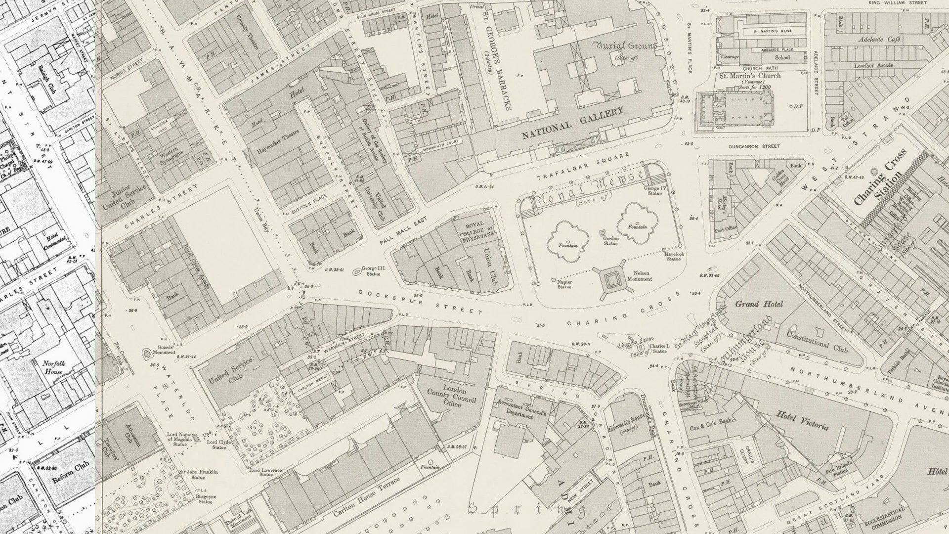
The wonderfully-detailed mid-1890s Ordinance Survey map sees the disappearance of Northumberland House and a new street called Northumberland Avenue in its place.
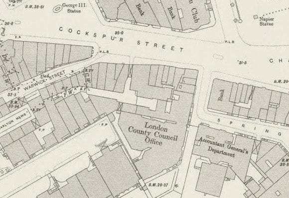
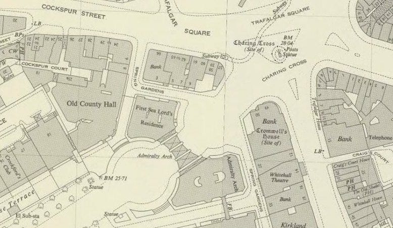
The old County Hall was known as ‘Spring Gardens’ - how London names morph over the years! This was the headquarters of the Metropolitan Board of Works but when the London County Council Office replaced it as a local authority, the larger new council needed a bigger building and it moved to the South Bank.
What's still missing in action is Admiralty Arch. Next map please…
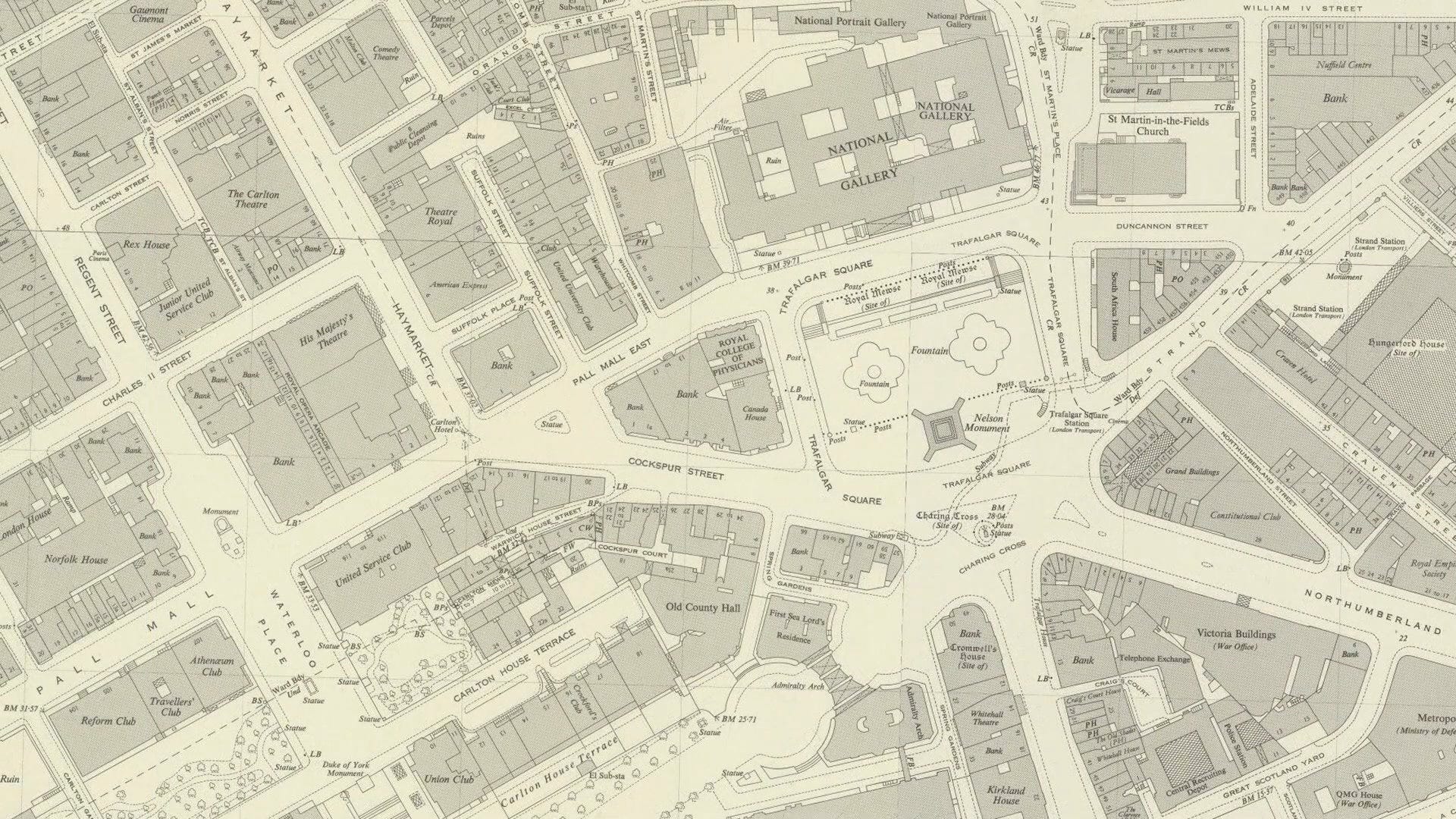
By 1950 The Mall does reach Trafalgar Square. Admiralty Arch adjoins the old Admiralty Building and was commissioned by King Edward VII in memory of his mother Queen Victoria although he didn't live to see its completion in 1912.
We're now up to date (unless this blog survives well into the future. For reference, it’s 2024 at time of writing). The modern map has largely inherited the built environment of the mid 20th century. The Second World War didn't see much of the destruction here that was seen elsewhere in London.
While our general story is complete there are many other tales to tell. But that’s for another time.
NOTES
Isn’t your own 1500s map b*ll*cks? I hope that you meant “wishful thinking”, or that’s plain rude. The Flemish artist Anton van den Wyngaerde created a panoramic drawing which provides the earliest visual record of the Westminster landscape. The Civitas Londinium, also known as the Woodcut or ‘Agas map’, was produced in the 1570s and gives a unique bird’s eye view of the area. I combined the details and researched the area. It took two weeks to do
Pre-history: 1950s building work on the south side of Trafalgar Square revealed deposits from the last interglacial period. Amongst the findings were the remains of rhinoceroses, straight tusked elephants, hippopotami and cave lions. Given the work of Mr Landseer, lions have a long history in Trafalgar Square.
Pigeons: Before 2001 you'd have seen a whole load of pigeons here, but the sale of bird seed in the square was stopped that year, and other measures were introduced to discourage the pigeons, including the use of birds of prey.
Video: Too idle to read so much text? The video below does the same job…
That statue of Charles I has an interesting history in itself. It's London's oldest bronze statue. It was originally made before the Civil War, for Charles' lord treasurer the Earl of Portland at his house in Roehampton.
From Wikipedia:
"After the Parliamentary victory in the English Civil War, the statue was sold to John Rivet, a metalsmith in the Holborn area. Rivet received instructions from Parliament to break down the statue, but instead he hid it on his premises. He produced some broken pieces of brass as evidence that he had followed his instructions, and for some time sold brass-handled cutlery to both Royalists and Parliamentarians, which he claimed was made from the remains of the statue."
So interesting. It's almost impossible to stand at Charing Cross and imagine that it was once all fields round 'ere, my boy.